From Mark at ESA-ESTEC in the Netherlands, 12 April
Thinking of the team out in the high Arctic, I’ve been checking up on the general ice conditions in the Arctic, and around the field site off Alert in the Lincoln Sea.
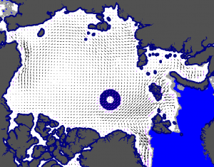
The first example shows sea-ice drift. This low-resolution product comes courtesy of the Eumetsat Ocean and Sea Ice Satellite Application Facility and shows sea-ice drift from 9 to 11 April. The arrows show drift direction with the length of the arrow indicating the relative drift speed.
The situation indicates that high pressure over the Beaufort Sea has spun up the Beaufort Gyre. Low pressure over Iceland is driving sea ice from east to west in the region north of Svalbard. This current situation leads to relatively benign sea-ice drift and stable ice conditions off Alert.
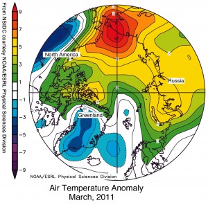
The second image shows ‘temperature anomalies’ or deviations from the monthly March mean surface air temperature in the Arctic, adapted from plots courtesy of NOAA. This indicates cooler than normal temperatures over Greenland, but slightly higher than normal seasonal temperatures in the Lincoln Sea. The general pattern over the Chukchi Sea is more dramatic, with seasonal temperature anomalies of 8°C above the long-term March average.
With air temperatures of around –27°C in Alert, this is all good news for the scientists out on the ice starting the campaign. Nevertheless, working in Arctic conditions poses huge physical and logistical challenges.
This is campaign is truly a huge effort, involving many organisations from different countries. Through this cooperation, we will be able to build up an excellent dataset to validate the measurements from CryoSat and understand exactly how Arctic ice is changing.
So from my comfortable office here in Noordwijk, I send greeting to my colleagues and wish them all the best for the coming weeks.


Discussion: no comments