As part of the recent series of trajectories around Comet 67P/C-G, Rosetta passed within about 14 km of the comet’s surface on Saturday. Despite operational difficulties encountered during the flyby, Rosetta’s NAVCAM was able to acquire images on the way in to and shortly after closest approach.
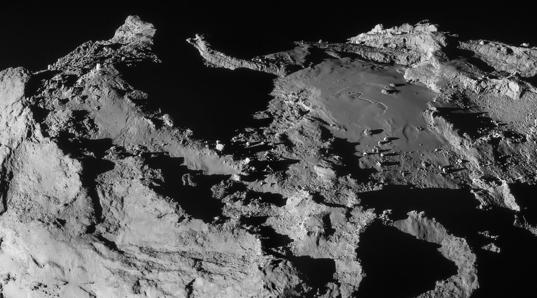
This stunning scene was created from two NAVCAM frames acquired at 19.9 km from the comet centre on 28 March. The scale is about 1.7 m/pixel and the image measures 3.1 x 1.7 km. The image has been adjusted for intensity and contrast, and the vignetting has been fixed. Credits: ESA/Rosetta/NAVCAM – CC BY-SA IGO 3.0
The approach images were acquired between 09:33 and 09:51 UT, and show an oblique view across the Imhotep region. This provides the focus for the two-image mosaic presented above, which has been cropped and rotated to highlight the impressive scenery.
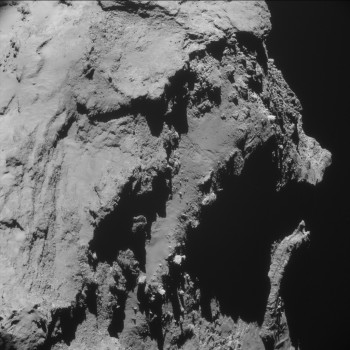
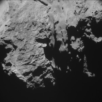
Focusing on the 2×2 montage in its original orientation (below), the scene captures the boundary between Imhotep and Ash to the left. The cliffs of Hathor on the small lobe are visible in the background at the far left. Note that the top-right frame also includes the region that was imaged during the 14 February flyby at 6 km.
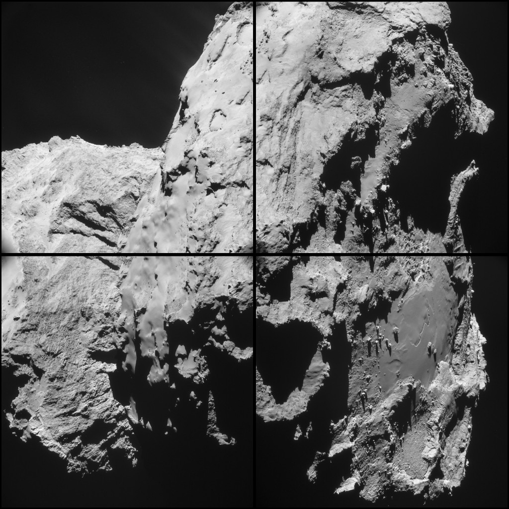
Four image montage of images taken by Rosetta’s NAVCAM from an average distance of 20.2 km from the comet centre. The scale at this distance is 1.7 m/pixel and the size of each 1024 x 1024 pixel frame is 1.8 km. Credits: ESA/Rosetta/NAVCAM – CC BY-SA IGO 3.0
The second set of images, presented below, was acquired between 14:35 and 14:53 UT, not long after the closest approach at 13:04 UT.
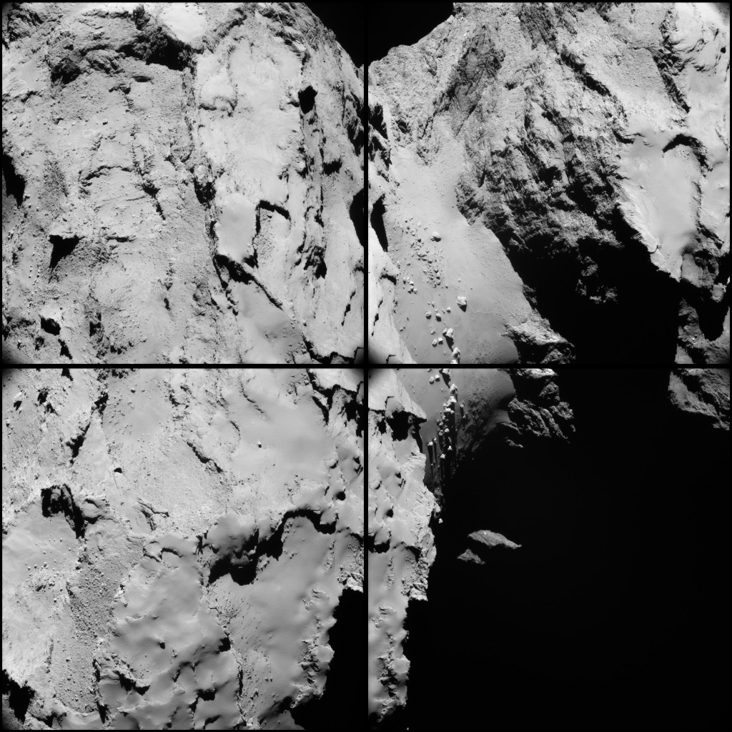
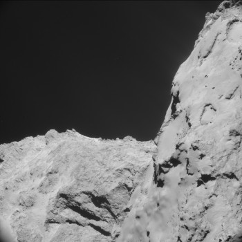
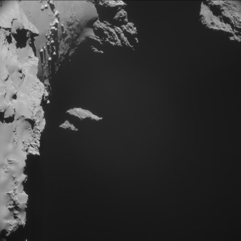
Four image montage of images taken by Rosetta’s NAVCAM from an average distance of 16.6 km from the comet centre. The scale at this distance is 1.4 m/pixel and the size of each 1024 x 1024 pixel frame is 1.4 km. Credit: ESA/Rosetta/NAVCAM – CC BY-SA IGO 3.0
In this orientation the large lobe is to the left and the small lobe to the right. The top right frame offers a particularly stunning view onto Hapi, the comet’s ‘neck’ region that is littered with boulders. This view also provides a good look at the many interesting, curved markings visible on the smooth surface.
In the same frame, further details in the cliffs of Hathor can be seen, leading up to the ‘head’ of the comet’s small lobe. The smooth region towards the right of this frame shows the transition between this smooth, presumably dust-covered portion, and the layered, exposed cliffs below.
Note that the montages have been tweaked in Lightroom for global intensity/contrast, but there have not been any local adjustments made of e.g. ghosts/vignetting or other local intensity mismatches. The four original 1024 x 1024 frames from the two image sets are provided below.
CometWatch will take a short break over the Easter weekend and will be back next Wednesday with a new view of Comet 67P/C-G.

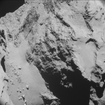
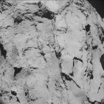
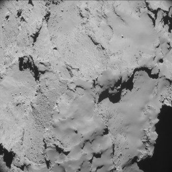


Discussion: 66 comments
First, awesome science and these pics are a privilege to see. Congrats to all involved making it happen!
Also, would it be possible to paste a known object, like a plane or a bridge, into the pics, so as to allow the uniformed observer, like me, to appreciate the scale of things? Having a description of the sizes, or even a map-like scale indicator doesn’t really help.
A small, well placed scaled object, nothing obtrusive or distracting, would elevate the sense of the peaks and valleys. Just an idea.
Thanks again for doing the science and bringing these pics to us!
Aesthetically, I think it would be absolutely awful!
The last thing a picture of such remote, beautiful, austere grandure needs is some bit of earth junk on it.
The scale tells you what you need to know.
Not sure, but I think you may have just hurt
Philae’s feelings 🙁
Junk is junk, doesn’t matter if earthly, and dust nebulas are very good at trapping anything 😉
That’s why comets are so interesting. They are ‘bags’ of surprises.
I have asked for this already so often. Not just here but on other NASA sites as well. But so far no reaction….
The boulders on the neck are about the size of blocks of flats and sky scrapers.
That kind of montages have been made. But I doubt they’ll publish them to a wider public, since there are enough conspracy theorists out there who would take that kind of montages for real.
“Stunning”, eh? Yes, I think you’re right. It’s going to be even more interesting to see these places again after perihelion. Thanks for this and the archive release.
Thanks for providing us with both, the enhanced pictures and the original frames! I enjoyed both of them and it was an additional pleasure not to be kept in the dark about what work had been done in the darkroom.
Georg F.Berger, Hannover, Germany
Under magnification, we can again observe in the extraordinary image at the top of the page (apart from the obvious, spectacular stratification), literally hundreds of examples of the sets of aligned “drill-holes” I have drawn attention to a number of times in previous threads. This ubiquitous phenomenon, observed at many different scales on 67P, still needs to be accounted for. Just one more puzzle for the standard theory…
Thomas: It is the same formation that was seen in the earlier close flyby of February 14. It took me a while to realize this!
Kamal
Do you mean the vertical black lines seen when you blow it up enough to see the pixels? They look more like image compression artifacts to me.
If real, a puzzle; but I’ve no doubt EU has an explanation.
Harvey, you seem to have forgotten that on an earlier thread, you actually admitted this phenomenon as “intriguing”and the appearance of the lines of holes as “pretty convincing”. It was in your post https://blogs.esa.int/rosetta/2015/02/16/cometwatch-14-february-flyby-special/#comment-381361, in answer to my own post https://blogs.esa.int/rosetta/2015/02/16/cometwatch-14-february-flyby-special/#comment-380641, in which I provided pointers to the most obvious examples here: https://www.flickr.com/photos/130179313@N03/16392831490/
The lines of drill-holes are even more obvious and numerous, under”*slight* magnification, in the image at the top of this page. So why this change of heart on your part? Why should they suddenly have become mere imaging artifacts, instead of being real? As indisputable observations, they simply need to be accounted for.
Could you actually answer a direct question just for once?
“Do you mean the vertical black lines seen when you blow it up enough to see the pixels? ”
The things I found ‘pretty convincing’ previously were not lines of pixels following the sensor matrix as what I’m seeing here is.
Is that what you are refering to or not?
If not, please provide a better identification.
A beautiful new view of the Imhotep region. We also get to see the other end of the Hapi valley which we don’t have a lot of good looks at from before. The ones we do have are more at an angle (https://blogs.esa.int/rosetta/2014/12/11/cometwatch-9-december/ is one example). Here again we see several “horseshoes”, but because of the lack of we lack images from above to compare with it’s difficult to say if they are relatively newly formed. I believe they are though.
This is also an area that intrigues me, seen https://i.imgur.com/rqUQY1P.png here. In the right side version I’ve heavily modified the brightness curves to make it stand out more, so be a bit careful over-interpreting it. I’ve pointed the area out before because it looked like it was darker than before https://i.imgur.com/6CmqPmj.png here. It’s very likely that it’s simply a trick of the lights due to the dune-like formations there and the slopes, but
This is one of the OSIRIS pictures from the area from way back in October https://www.esa.int/spaceinimages/Images/2014/10/Philae_s_backup_landing_site_from_30_km_b. Makes for a great comparison..
First image (https://i.imgur.com/rqUQY1P.png)
Credits: ESA/Rosetta/NAVCAM – CC BY-SA IGO 3.0
Second image (https://i.imgur.com/6CmqPmj.png)
Credits: ESA/Rosetta/NAVCAM – CC BY-SA IGO 3.0
ESA/Rosetta/MPS for OSIRIS Team MPS/UPD/LAM/IAA/SSO/INTA/UPM/DASP/IDA
https://creativecommons.org/licenses/by-sa/3.0/igo/
Emily: In your bimontage, the peaks receding to the horizon from the right hand side are in Khepry. Which region are the peaks receding to the horizon from the left side in: Atum? This is not clear from the maps put out so far.
Hi Kamal
If you refer to the bottom left map provided at: https://www.esa.int/spaceinimages/Images/2015/01/Comet_regional_maps but turn it upside down that may help 🙂 With that as a guide, you will find a small portion of Apis on the far top left horizon with the lower left foreground in Ash.
Hope that helps!
emily
Hi Emily, Thanks, but still a question remains: What is on the other side of Imhotep between Apis and Khepry?
It’s not entirely clear though. As you said, Apis is on the bottom left map, but if you use that as a guide then it should also show up on the upper left map which it doesn’t. So the boundary is quite unclear.
https://i.imgur.com/UDrKeNO.png – this is, roughly, where Apis is according to the bottom left map.
Credits: ESA/Rosetta/MPS for OSIRIS Team MPS/UPD/LAM/IAA/SSO/INTA/UPM/DASP/IDA
It’s at the edge of what was the dark side of the comet either way, so it might just get remapped later.
Indeed, it seems to be on the as yet unmapped region.
There is a shining white boulder above left in the bimontage, looks almost like an astronaut in their spacesuit standing there. Appears to be similar in size to Cheops.
Is it a boulder? Can’t find it in earlier Imhotep pictures.
In https://blogs.esa.int/rosetta/files/2014/12/ROS_CAM1_20141214C.jpg there is an area of white boulders (one of which has a black “head”). I think that the perspective from which the present image is created merges more than one white boulder into the “space man”. I can also recognize in the December 14 image the peak seen behind.
Kamal
Fabulous pictures, on earth you could hang around all day to get lighting as good as this, and then it be ruined by a cloud.
also love Kamal’s space man.
Thomas, threads of drill holes of are either multiplying, or photography is better, but still its an interesting puzzle
Excellent images! Now someone needs to do a 3d model.
@ Karon: “paste a known object, like a plane or a bridge, into the pics…”
Cheops at Cheops…
https://univ.smugmug.com/Rosetta-Philae-Mission/Rosetta/i-P3KVxKp/0/L/ESA_Rosetta_NAVCAM_141008_A–cheops-L.jpg
–Bill
Excellent idea. Now that gives a good reference for scale… thanks.
Regarding the navigation problems that you mentioned in the parallel blog, overflying which region of the comet did they happen? The dust jets look strongest over Hapi, so that is what I would expect, but it would be interesting to know if they happened someplace else.
Thomas,
Would you be so kind as to show where some of the “drill-holes” are located?
Thanks Emily, outstanding images. I can’t wait for more as 67P gets closer to sol.
WayneC,
I think (but not sure) Thomas is referring to the grooves that run across the “broken” edges of the “sedimentary” layers. Since we have so little experience with the extreme conditions out there, it will be fascinating to watch this thing fizz.
Will it spin up from emitted gas? Does it erupt from within, or is it repeatedly struck by chunks of spew falling back onto it?
There are many many suggestions of violent transformations on the surface of this thing. Perihelion should indeed be interesting.
My take on these mosaics:
First one: https://www.flickr.com/photos/105035663@N07/16382022543/in/photostream/
Levels adjusted to show jets: https://www.flickr.com/photos/105035663@N07/16794798487/in/photostream/
Second mosaic: https://www.flickr.com/photos/105035663@N07/16401495263/in/photostream/
Zoom on Hapi region: https://www.flickr.com/photos/105035663@N07/16836637039/in/photostream/
Very nicely done. Thank You.
Thanks a lot for the work at that Hapi ‘blue’ region, Thomas 🙂 Fresh material exhibiting simple porous sublimation [circular concavities with a central protrusion].
it needs a banana for scale
Hi, at this time a huge amount of images are present in high resolution, has this material ever been evaluated if there are any changes of the comet surface at all? So far the only known change is the impact traces that Philae made in the past. Will this comet pass the Sun without any other noticeable marks but the outgassing? I expected a lot more activity then so far. Still hoping for a land slide to occur.
Yes it has been evaluated on this aspect.
Some subtle changes at the smooth dusty neck area seem likely. But you need some experience to perceive it, since light conditions together with shadows are changing, too.
I “guess”, that the changes will get more obvious over time.
Hi Emily, Rosetta’s Teams and ESA. The treasure chest brought by this latest flyby is invaluable.
https://www.esa.int/spaceinimages/Images/2015/04/Comet_on_28_March_2015_NavCam_montage_a
Evidences of ‘plasticity’ at pixels 1710,1797,
Imhotep ‘burping’ becoming jetting. Showing tangential-ity. Older layers someway impermeable.
‘Drawings’ very evident without contrasting. ‘Drawings’ are 3D phenomena. Varying angles say it.
Sub-surface flow at pixel 878,1229.
Generalized [on depletion] collapsing and fracturing of superficial layers.
At pixel 1656,1200 in Imhotep another sub-surface flow with deep material’s sinking.
Imhotep showing characteristics of a basin.
If asked about the macro structural nature of cometary material I would point to a particular ‘chunk’: pixel 1413,765.
Thermal stress is a really big deal to low porosity surfaces :/
This is joyful madness: Is Cheops giving a hint of a reflection at left of base?
https://www.esa.int/spaceinimages/Images/2015/04/Comet_on_28_March_2015_NavCam_montage_a
Terminal moraine near Imhotep horizon, around pixel 1825,1135?
https://en.wikipedia.org/wiki/Plucking_%28glaciation%29
https://www.esa.int/spaceinimages/Images/2015/04/Comet_on_28_March_2015_NavCam_montage_a
Logan’s definition: ‘Thermal scales’ are on the plains round collapsings of the surface. Forming phenomena being like in cenotes, but erosive agent being sublimation [not dissolution].
https://en.wikipedia.org/wiki/Cenote
Pixels 886,493 and 1003,141 of
https://www.esa.int/spaceinimages/Images/2015/04/Comet_on_28_March_2015_NavCam_montage_a
Speculatively due to full ice depletion and consequent collapsing of the composite material.
Break line or former glacier at point 1634,446 of
https://www.esa.int/spaceinimages/Images/2015/04/Comet_on_28_March_2015_NavCam_montage_a
Once you see it, also all the ‘river’ of materials.
‘Salting’ dune at pixel 1242,426. Same montage_a from mar28.
‘Salting’ dunes could bend tangential jets.
Thanks for all the NAVCAM goodies, Emily. The double montage at the top of this blog rates as one of the best images of 67P’s surface we have seen. The lighting and viewing angle are excellent.
https://www.esa.int/spaceinimages/Images/2015/04/Comet_on_28_March_2015_NavCam_mosaic
There is just so much going on here, such varied terrain, so many possible mechanisms and processes, to create this alien vista. The terrain on the left reminds us that 67P is actually a huge “mud brick” held together by volatile ices rather than water and is Antarctic Dessert dry. The sintering of the ices mixed with organics, creates a thin “glaze” of hard surface as a brick fired in a kiln might have.
Unlike, the terrestrial planets, as logan points out all the erosion is from within and determined by the topology of the surface and the chemical composition of the sub-surface. The shadows of the cliffs and ridges determine where subsurface erosion takes place. The snaking scarp through Imhotep follows the profile of the high ground of Khepry to the right and the rugged pitted terrain to the left of the smooth Imhotep plain, is defined by the shadow cast by the high ground to the left.. Only when an area is free of shadow and the amount of energy reaching the subsurface is sufficient energy able to engender increased sublimation from below the surface.
In the Northern “hemiduck” during the long period when 67P is outside the snow line, the shadows barely move and preferential erosion has many years to build a rugged and topographically varied surface.
From what we have seen of the Southern “hemiduck”, it is a lot more level terrain, with far fewer pits and ridges. Surface temperatures even in the shadows during its few months of direct solar exposure, are considerably higher and the areas in prolonged shadow are minimal, due to the rapid changes in the angle of the sun during the “Spring/Summer/Autumn” phase of 67P’s orbit.
So in general the Northern “hemiduck” has a a lot more dust that condenses from the thicker coma created in Summer, its terrain is more rugged and varied, due to the shadows and greater temperature variation leading to differential sublimation of the volatiles, creating uneven surface collapse. In the Southern “hemiduck” increased temperatures allow sublimation of all volatiles from the sub-surface and for longer when surface is in shadow, which is drastically less anyway, which leads to greater surface erosion, more dust expulsion, less insulation and a more level terrain.
The thorny problem is what happens in the neck region, where shadows from the two lobes are key. Firstly each side of the valley has a totally different type of terrain. On the head side we have the cliffs of Hathor, which tend to match the surface of the Southern “hemiduck” and the Seth region that is gnarly, pitted and irregular matching the topology of the Northern “hemiduck”. I would suggest this is due to the smaller shadow of the head lobe creeping across the Seth region, whereas the larger shadow of the body lobe quickly covers the majority of the Hathor cliffs so that large scale erosion only occurs at certain times of day and more crucially at certain times in 67P’s orbit.
Thanks again to the NAVCAM and Outreach teams for giving everyone the chance to gaze in wonder at this fascinating little world. Some of us want to help figure out whats going on, but most just want to see the amazing images of this alien and one time mythical object that is the comet 67P.
Would like to see a graphic with latitudes explaining this northern and southern hemiduck business. Wikipedia says the orbit is inclined 7 degrees, that should be the inclination of the “ecliptic” plane of 67p to the plane of the solar system (?). The axial tilt of its equator (to 67p’s “ecliptic”?) is 52 degrees, which suggests that in summer everything above 38 degrees north should be in darkness during the full 12-hour rotation, and everything above 38 degrees south should be lighted up whether it is “day” or “night” on 67p. I don’t know whether the 7 degree inclination works in an additive or a subtractive way, or has no effect.
Incidentally the Earth is at perihelion in January, also during the southern summer.
Perhaps the Osiris team could add some latitude lines to the pictures in https://blogs.esa.int/rosetta/files/2015/02/ESA_Rosetta_OSIRIS_erosion.jpg.
Kamal
Anymore can explain to myself this 67P’s geology without mud. Can we bring back to front stage that ‘spirituous’, Teutonic word we selected sometime ago?
Dear Rosetta’s,
Do not do this again !
Just watch a bit away.
Vriendelijke groeten, Henk Smid
A glass of lakritze is welcomed now. Cheers to ESA! Please allow me to include the Niels Bohr Institute.
An ice skater can skate on ice because the extremely high pressure created by the tiny contact point of the skater’s blade is sufficient to melt a tiny amount of ice and thus lubricate the motion of the skate across the ice. Is there enough mass pressing down on the interior layers of the comet to create a pressure sufficient to melt any of the volatile ices, in particular Carbon Monoxide and Carbon dioxide I wonder? If the apparent surface flow is glacial rather than fluid flow, as Logan suggests, could such pressure induced phase changes be the source of the lubrication required for such glacial flows? Could this explain the layering we see, each level of phase change creating a discontinuity and sideways slippage?
The low density of the cometary material makes me think this unlikely, particularly for Water, but no doubt members of the science team have done the numbers and could rule it in or out as a possible scenario for the more volatile ices. The continuous seepage of Carbon Monoxide and Carbon Dioxide from the un-illuminated areas of the comet suggests there is another mechanism for their production deeper within the comet. We know from the MIRO data that temperature falls rapidly below the surface and the thermal conductivity of the sub surface is very low, making it difficult to understand how sublimation can still take place during the comet night when all the near surface sources of these two gases would have already been exhausted by daytime thermal conditions.
I fear that 67P is just not large enough for this pressure induced sublimation process to be a factor, but it would be interesting to hear other views.
Robin
The idea that skates melt a thin layer of ice is widely held, but at least for temperature below -3.5C long since discredited. See
https://physics.ohio-state.edu/~jay/846/skating.pdf
For example.
The pressures involved are also very large, hundreds of bar.
Given the low density, and low Gravity, pressures will not be all that high, and the comet clearly doesn’t act as a fluid, further reducing the internal pressure.
Finally, you only expect pressure melting for a material that expands on freezing like water, (Le Chatelier’s principle) which is fairly anomalous in that respect; most things contract. One would need to check whether CO, CO2 etc expand or contract to see if it would apply at all.
So like you, I rather doubt this mechanism is a factor.
Blade skating. Point skating. Focalized melting. Generating transient liquids. Sneakily draining, sinking, not too far, before freezing again. Progressively sealing cells, small ducts and niches. Those ones creating more liquids by temperature and pressurization. Like the image! 🙂
“…Could this explain the layering we see, each level of phase change creating a discontinuity and sideways slippage?”
Do Robin refer to the kind of slippage that normally occurs un-adverted [and help to create layers in snow], but at catastrophic threshold causes avalanches?
“…I fear that 67P is just not large enough for this pressure induced sublimation process to be a factor”.
I would say ‘pressure induced liquefaction’. Blog contributors have chatted before about brine, and Neils Bohr Institute is presenting a document on Mars considering this feasibility. Neither we know the physical specifics of organics at 67P. Why discard so quickly?
Not so easy to put numbers into tidal heating.
This is very much a straw man to see if someone can do better or correct it.
The easiest thing is to try and get an idea of how it compares to earth, where it’s a pretty small but real effect.
If one starts from
https://en.m.wikipedia.org/wiki/Tidal_heating
The obvious scaling is the n^5r^4e^2 term.
n is the mean orbital motion, r the body radius, e the eccentricity.
But it’s really power *density* that matters surely, so it becomes
n^5 r e^2
(In absolute terms the r^4 term would be a killer, but that’s not a sensible way to look at it.)
Now that n comes from
https://en.m.wikipedia.org/wiki/Mean_motion
And since Msun>>>m67P or m Earth n scales as a^-1.5 so overall we have
a^-7.5 r e^2 as the scaling, with a the semi major acxis of the orbit, r the body radius, and e the eccentricity.
The a and r terms reduce it, the e term increases it.
*if* I’ve got my sums right, that’s around 500,000 times weaker than earth; I’ve ignored differences in the shear modulus, because I’ve no idea what to use! But I don’t think it will overcome that 500,000.
Not really on my home territory here; can anyone do this better, especially an absolute estimate?
But I rather think it is indeed very small.
On further consideration, I’m not convinced the Wiiki formula is relevant. It’s also, for Wiki, rather poorly described regarding what some of the parameters actually are; ‘Q’ for example seems to be implied to be a dimensionless *constant*, but other articles suggest it’s dimensionless – but not constant. And it’s not clear what the result actually is – even its units. There are other aspects that bother me.
For highly elliptical cometary orbits, with thermal inertia small compared to that of typical moons, we are interested in the way tidal heating power varies with time, not just an orbital average.
Now this is a gravity *gradient* effect, and the gradient increases near perihelion. However, since comets are very small, one still expects a small effect.
Overall this needs much more careful consideration than plugging numbers into a Wiki formula. I’m rather too far off home ground to try and do it ab-initial but I will dig in the literature later.
I would be a bit surprised if ‘the grown ups’ haven’t run the numbers and concluded its negligible, but just maybe it’s been overloaded Kee.
Hi Robin,
I think the circumstantial evidence for internal heat process is strong, and so is that for liquid water. I sometimes think that the comet acts like a big flywheel, and tidal friction causes the required internal heating.
The Circumstancial evidence is also that all the outgassing originates internally, and quite deeply at that (50m or more) and does not remodel the surface directly.
It’s an interesting point that superficially at least the behaviour would seem more easily explained by an internal heat source.
But that source has to be triggered by the approach to the sun.
I tried to get an estimate of tidal effects, and they seem small – as you would intuitively expect for such a small object. But I’m not confident of that sum. However I would have thought this would vary a lot with differing comet orbits for example, so it really should have been spotted long since if a factor, it’s very well known.
I let my imagination run wild for a bit, but can’t think of anything else remotely credible that generates a near perihelion triggered internal heat source.
In the end it’s probably just that obvious solar radiation input playing tricks on us in an interesting way.
Hi Harvey,
Note that on earth, tidal friction is more about the exchange of energy from rotational kinetic energy to thermal energy, with the conservation of AM being a major factor. Ie. The Earths rotation slows down, the moon’s rotation speeds up (slightly) and Earths water tides and their friction is the momentum exchange mechanism.
On 67P the tide is coming from the sun, but the high tide, low tide cycle is dependent on the rotation speed and axial tilt. Distance from the sun at the point of *Equinox* in this case is where tidal forces can perform the most “work”. If this is a major source of heat, the peak outgassing will be at the equinox closest to the sun. For 67P this would mean a double peak and more of a lull at the southern summer solstice in between. My rough reckoning would intimate that at constant angular momentum a more stretched comet would have less rotational kinetic energy, and thus if tidal forces performed work to stretch the comet, a great deal of frictional heat would be created internally to cause the outgassing. The friction would passively stop the individual lobes from rotating independently to balance AM.
Marco: The ESA website says:
The Sun is overhead at the comet’s equator about 120 days before perihelion. If the comet behaves as in 2003 and 2009, the main jets should become visible a month before perihelion, i.e. mid-July 2015.
Now that you present the argument in that way, Marco. We know a lot more about the ‘loose’ inter-layering macro structure. Also about the ‘fluffy-ness’ of micro structure. Should we take more seriously the strength of orbital to tidal energy transfer?
Hi Logan,
Well, yes. The lobe to lobe and solar tidal effects have been pretty much ignored, so far. This is because they are considered too small, and there is, as yet, a lack of evidence of momentum transfers and friction. (Earths oceans are required, for instance, through their friction over tidal cycles, to lengthen our days, converting Earths angular kinetic energy to heat, and passing some angular momentum to the moon.)
Some sort of internal liquid or plastic response to lobe movement would be a prerequisite.
Ah, I think I see how to check this.
It would show as a distinct slowing down of the rotational period from pre to post perihelion surely? Is there evidence comets consistently slow down at that time?
Then, given the fact that we know the moment of inertia & the period, one could calculate the average power dissipation.
Now of course the period is also affected by gas jets; but one ought to be able to put some sort of bound on the process like this?
Hi Harvey,
You are starting to think this the way me and A.Cooper are thinking this. However, *equinox* should be the peak slowdown, not perihelion. At perihelion, based on the previous orbital cycle of 67P, spin rate should accelerate rapidly due to asymmetrical outgassing.
Have a look at various journals/research on spin rate evolution of various comets. I think Temple 1, and Hartley 109P have very interesting spin rate evolutions.