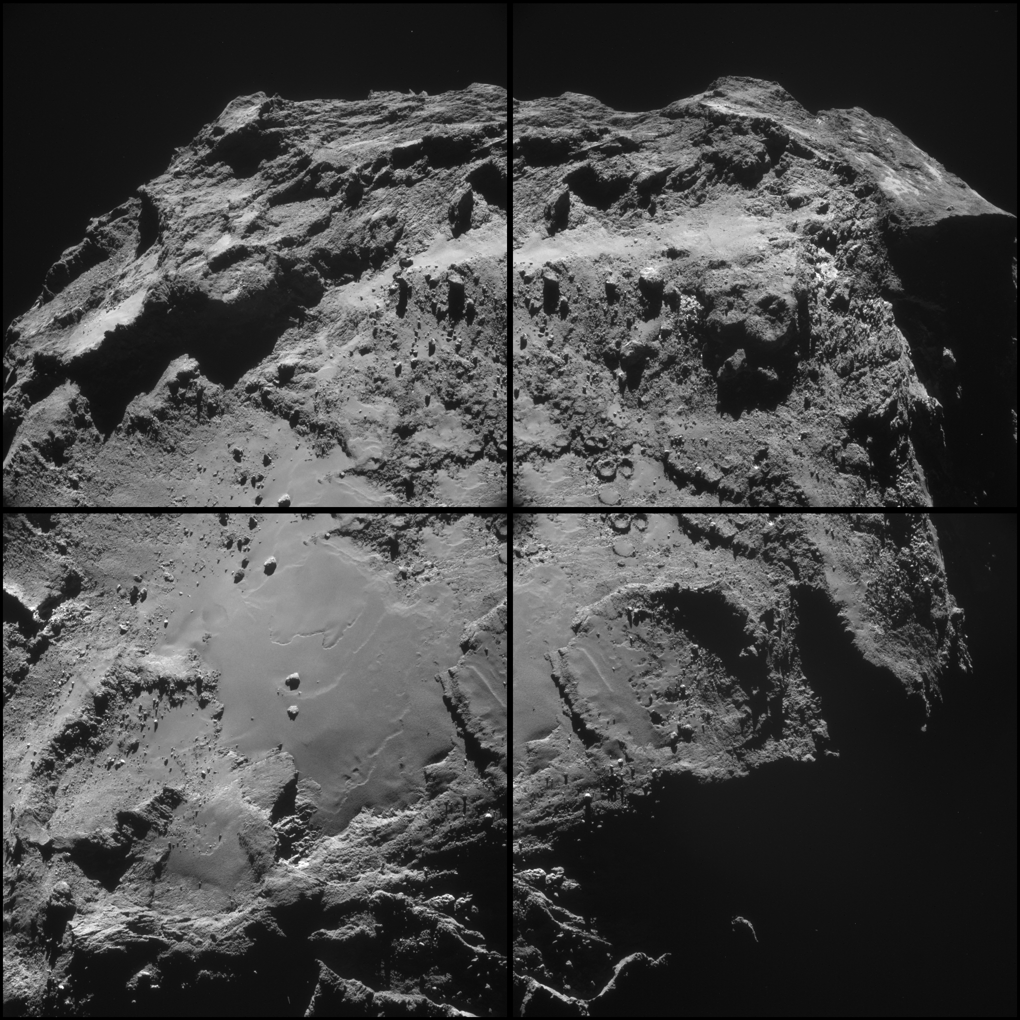
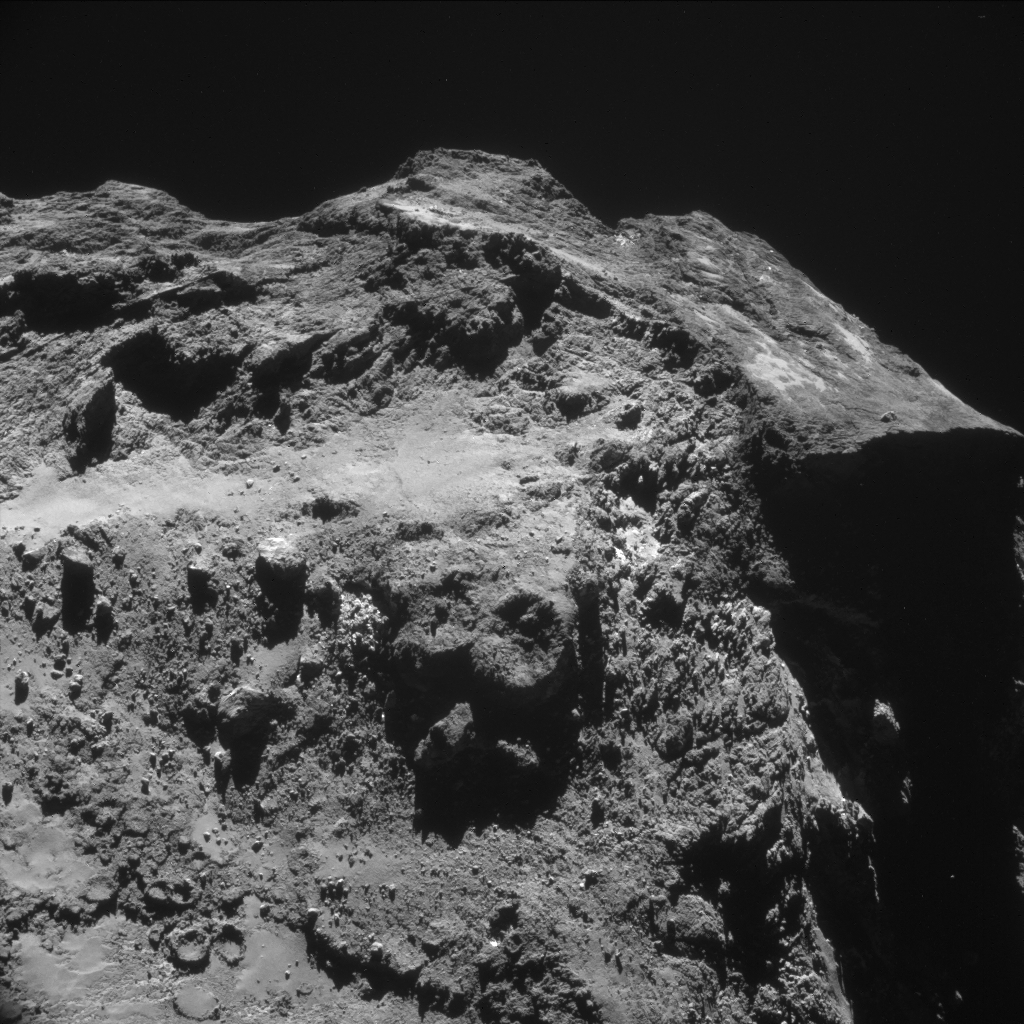
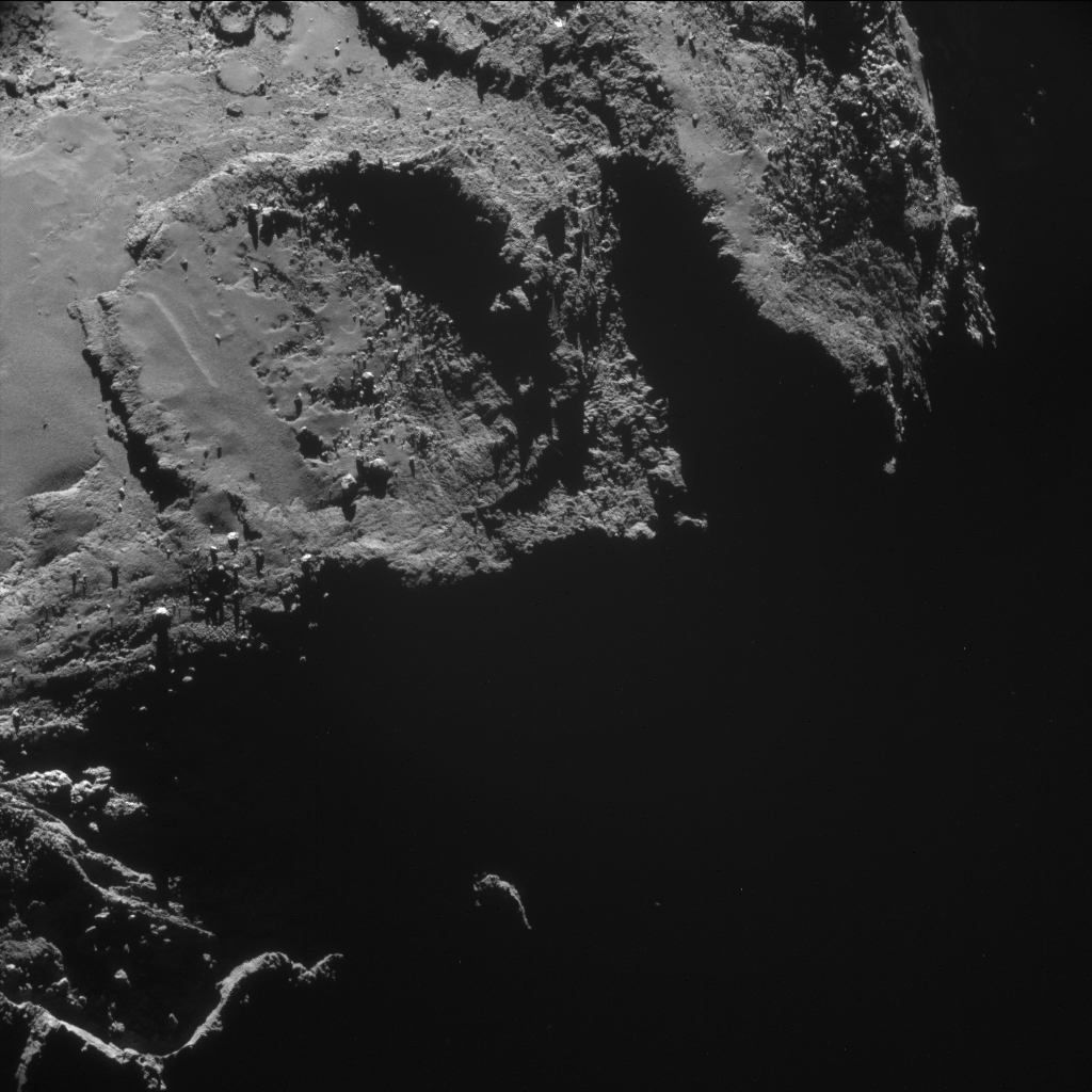
This four-image mosaic comprises images taken from a distance of 19.4 km from the centre of Comet 67P/Churyumov-Gerasimenko on 14 December. The image resolution at that distance is 1.66 m/pixel and the individual 1024 x 1024 frames measure 1.7 km across. The mosaic is slightly cropped and measures 3.0 x 3.1 km.
As usual, rotation and translation of the comet during the image sequencing make it difficult to create an accurate mosaic. As always, refer to the individual images below before drawing conclusions about strange structures seen on the comet or low intensity extended emission.
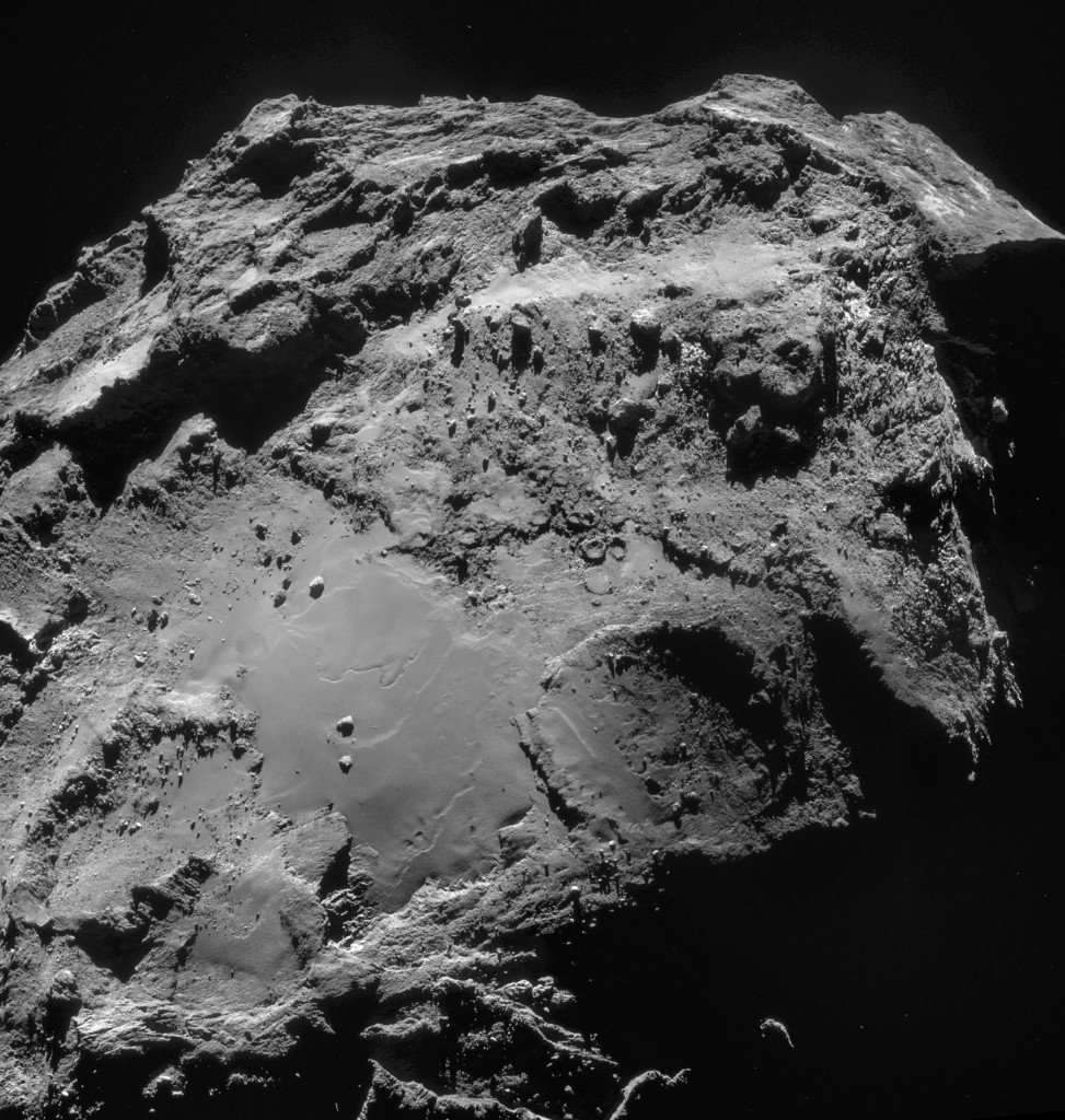
Four-image NAVCAM mosaic comprising images taken on 14 December. Credits: ESA/Rosetta/NAVCAM – CC BY-SA IGO 3.0
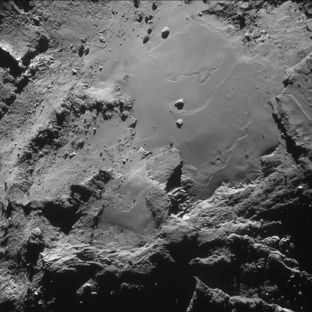
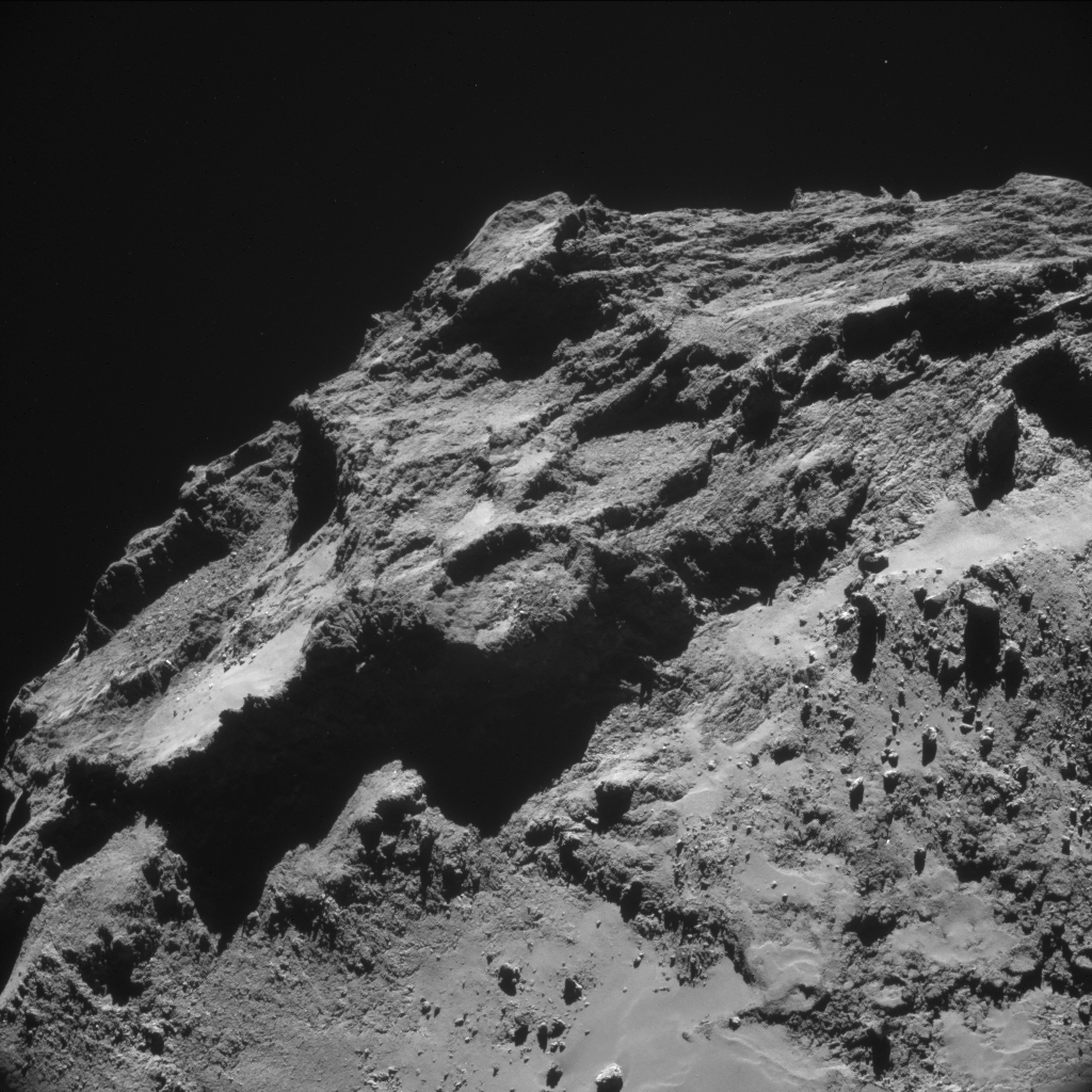
Today’s mosaic shows the underside of the larger lobe of Comet 67P/C-G, providing yet another view of the region that is home to Cheops and its neighbouring boulders.
In line with the Ancient Egyptian naming scheme agreed by Rosetta scientists for features on the comet, this smooth region and the rougher terrain towards the upper right from there has been named Imhotep, after the famous architect of Egyptian pyramids from the 27th century BC. The name of this region was revealed during a talk at AGU today.
The image also highlights the difference between the smooth region where Cheops is located and the areas around it, rich in craters, pits and cliffs.
In addition, it is interesting to note that the Cheops boulder (upper and lower left frames in the montage above; see here, here and here for previous views) has now become an essential element in the proposal for establishing a scientific coordinate reference frame on the comet. In fact, one of the axes of this reference frame runs from the centre of mass of Comet 67P/C-G through the Cheops boulder.
The individual image frames are provided below.


Discussion: 20 comments
fascinating images, I could look at this for ages just trying to take in what and where it is. what an acheivment. So proud of your team on these manificent images.
We have seen them before, but centre picture there is a different view of several paired craters, that look unlikely to be impact related.
There are a couple of larger ones to the right of the the main conglomeration of them.
Strangely some of the rocks/boulders seem paired, I have not noticed this before but from this view it shows up, or my imagination has gone to far.
Hi Dave, that cluster of craters seems unlikely to be as the result of impacts as you say, it looks more like a field of “mud volcanoes” or geysers.
This photo highlights the same traits that all the other suggested ‘missing slab’ areas have: at bottom-left there is what appears to be cleaved, fresh strata. At top-right there is the rough terrain in a fairly steeply sloping ridge and an obvious, vertical break line at the top of this ridge.
These are the same characteristics as are seen in the head ‘crater’, which Marco and I believe may be a missing slab. The head and base of the comet are the two most likely areas to lose slabs if that did indeed happen.
The lower-left strata area is where the ‘rock’ would have cleaved (in the same manner that a quarryman levers up a slab clear of the next stratum). And the upper-right broken area is where the entire slab would have hinged away, leaving a fractured appearance. The final vertical ridge is where it would have broken easily and cleanly due there being almost no resistance to the leverage of such a huge slab.
There are scenarios whereby this slab loss might happen as suggested by me and Marco elsewhere. Some scenarios would be favourable to the hingeing behaviour or even require it to happen that way.
The other suggested missing slab areas are in three long arcs along the whole side of the body, below the head. The most obvious of these is Landing site A (the smooth crater). This has the same flat area to the front and the same sloping, fractured area to the back with a very defined, vertical break line at the top. This vertical break has defined ‘teeth’ marks which could be due to a clean snapping-off at the last moment. Photos illustrating all our supposed missing slab areas are below. They all exhibit the features described above.
Head:
https://www.esa.int/spaceinimages/Images/2014/12/Comet_on_7_December_2014_NavCam
Site A:
https://www.esa.int/spaceinimages/Images/2014/08/Candidate_landing_site_A
Photo of all three slab arcs on side of body:
https://www.esa.int/spaceinimages/Images/2014/08/Comet_on_19_August_2014_-_NavCam
In this last photo, site A is nearest. The shadowed V is the other large slab area (broken area about where the V is and cleaved smooth above that. The third arc is smaller and is in the middle between the other two. The site A slab probably arcs round to the two large craters on the right, hence the ripped-up, scree-strewn nature of this area. It stops roughly along a line that angles towards the neck. That appears to be the remnants of a ridge that aligns with the ridge on the neck above it.
The half-crater next to the head ridge almost aligns with the half-crater below on the body. The protrusion at the end of the ridge appears to fit to the raised portion below (in other photos) but it’s difficult to tell from the other photos at the moment.
Hi mr Cooper, Do you have any theories as to why the sheared slabs are all roughly circular? I am not sure if it is a function of the forces, or due to the way the layers got there in the first place. It is intriguing that the surface is solid enough to break cleanly and retain its shape in spite of large internal mass loss, yet the neck is flexible enough to stretch, and strong enough to resist mutual gravitation of the lobes. It is quite a curious mix of mechanical properties – but that is what the data is telling us.
Great work by ESA and its international teams.
I think it is time to archive the Philae Blog: https://www.dlr.de/blogs/en/desktopdefault.aspx/tabid-8684/
It is not being updated, July 2014 is very old!
I know this is a Rosetta blog but with no active Philae blog, we are forced to get reporting from NASA: https://www.nasa.gov/jpl/rosetta/pia19097/
Cheers
Well, we’re quite catholic here, actually: for us at ESA, “Rosetta” means the whole mission, including the Rosetta orbiter and its instruments, and the Philae lander and its.
So, in principle, you should be able to get wide coverage of the whole mission here, although of course we realise that more specialist knowledge may be available from other sources.
And keep in mind that when it comes to scientific results, we’re only able to publish materials that are sent to us by the various external instrument teams. The only real exception is NAVCAM, which is an ESA-owned camera system.
OK I have a candiate Philae trajectory on this photo!
The AGU finally released the mysterious CIVA Philea in transit picture. https://www.nasa.gov/jpl/rosetta/pia19094/
The blur is from the spin/tumble – so I applied blur motion filters to remove as much as possible. Note it leaves a bright line at the top and a dark line at the bottom. However this really seems to work, real features can be made out and in particular a very unique heart. A very similar heart is in this nav cam image (slightly different sun angle), and the rest fits as well. I think its a viable candidate and is consistent with my large lobe landing hypothesis. The time take on the AGU press conference slide was 17:40 – I’m guessing that is earth received time as it was supposed to be landed by then so that would make it 17:12 spacecraft time (I don’t know what the internal Philae data buffer delay is)
Here is the blur corrected image:
https://s7.postimg.org/3y4vy25p7/pia19094_bounce_motion_blur_filter.jpg
Here is the heart shape in the navcam image
https://s28.postimg.org/6rr7uuft9/Comet_on_14_December_2014_Nav_Cam_heart_annotated.jpg
Here is the deblurred in transit CIVA image superimposed on the navcam pict.
https://s27.postimg.org/ozdy1hqw3/Comet_on_14_December_2014_Nav_Cam_pia19094_heart.jpg
If this is right it would quickly narrow down the final resting place corridor and hopefully prompt a new OSIRUS image campaign – as the current campaign is solely focused on the small lobe hypothesis.
A followup – this Philae Candidate location is right in line with the previous trajectory and is bright, no shadow and has the rocky cavernous terrain consistent with the CIVA images. I’d say why not take an OSIRIS image of it!
https://s3.postimg.org/hkn23suwz/Comet_on_14_December_2014_Nav_Cam_Philea_Candidat.jpg
Dear Ken,
The 14 December NavCam image shows the underside of the comet’s larger lobe, while Philae landed on the smaller lobe. So I don’t quite understand your analysis…
Claudia,
My main point of this posting is to show that the blurry image has use in narrowing down landing site trajectory candidates and I have provided an example that fits well without any biasing assumptions. The image may fit other locations as well.
The current hypothesis is that it landed on the smaller lobe, driven primary by CONSERT data which was initially driven by assumptions of a smaller lobe landing to obtain the initial CONSERT slices. In past blog posts on the CONSERT data I have talked about possible solutions on the large lobe and if the CONSERT data was reanalyzed with other targets would it fit? I have a feeling it would looking at the geometry of the passes and the fact that the slices were take through the comet – so there are many possible slices. The new ranging CONSERT mode looks good, but it may be equal distances to large lobe spots at that point in the rotation cycle when they got the data. I think it is worth reanalyzing and seeing if it could fit large lobe locations.
Anyways in the large lobe hypothesis – the range of possible trajectories usually hits midway on the large lobe – but it is possible that it would go far enough and go sideways around the midpoint of the larger lobe to this location. Alternatively (less likely) high enough to go over the top to the back of the larger lobe. We don’t know much at all so all options should be considered, and there is no more concrete data than this picture available. There are probably less then a dozen places on the comet where this picture could fit the terrain, lighting crater density and shapes – that data should be actively considered if this next OSIRIUS campaign comes up moot. A picture is a 1000 words and a blurry picture is at least 100 , especially since the blurring is quite linear due to the spin/tumble rates. We should use all available data and not constrain analyses based on going in assumptions in such an unknown scenario as this.
Another great image Claudia. An excellent comparison is this image. In her post Emily talks about some brighter material resulting from an apparently fresh landslide or cliff collapse. This can be seen top left side of image A here.
https://blogs.esa.int/rosetta/2014/10/29/cometwatch-26-october/
Fabrizio Capaccioni in his VIRTIS – M talk at the AGU showed the VIS-IR spectra of this pile of rubble with its bright “white” cryorock surfaces, and it showed the characteristic spectra of Water. The nearby grey and dark grey areas showed no measurable Water. This says to me that where we see the brighter “white” surfaces in the NAVCAM images we are looking at exposed Water Ice. The general theme of all the results from the AGU is that the top cm of the surface layer has no ice, but it is increasingly present below this top layer, mixed in with dust and organics in a layer 10 to 20cm thick which sits on a hard layer of sintered powdered ice/snow.
This material has actually been simulated in lab experiments which took comet components and “manufactured” artificial comets and exposed them to outer solar system conditions of temperature, vacuum and UV/Cosmic Ray exposure. At the time these occasional appearances of a hard sintered surface were dismissed as aberrations or not realistic. The lander team had used many of the other results in their surface simulations, but not these implausibly hard surfaces. That experiment is already being revisited no doubt to investigate the nature of the Cryorock material. It has been suggested this is a new type of Ice, TYPE X (10), however as I have suggested before the material is a composite of dust, ice and organics and is not pure Water Ice at all.
Comparative montage of 26 Oct 14 Navcam and 14 Dec 14 Navcam images.
Scale approximately 0.65 m/pixel
Image Source: ESA/Rosetta
CC: BY-SA IGO 3.0
Processing by Bill Harris
https://univ.smugmug.com/Rosetta-Philae-Mission/Rosetta-Comparative-Series/i-VHXCSZz/0/L/compar_NAVCAM_26-oct_14-dec-14_cheops-L.png
–Bill
I did a comparison myself and I can’t say I see that anything has changed between the two as long as you take the change in lightning into account. It is interesting to see how the the change in resolution/lightning can make things look quite different though.
I made a gif out of the difference at one particular place, just to show this effect.
https://i.imgur.com/F9KjzuP.gif
The “boulder” just up and to the left of the centre in the image looks quite different due to the resolution/lightning change. The image also contains what (with a very heavy dose of imagination) looks like an obelisk just down and to the left of the centre, which I think is quite neat.
Marco
It’s interesting that you touch on the forces versus structure. I’ve been largely focussing on structure of the slabs including the related property of being heavily stratified. But your comment (along with one of Robin Sherman’s about explosive gases ejecting boulders onto the neck) has made me think about sublimation working the slabs free. I’m wondering if they could have been fracked by gases getting between the strata and finding their way towards the edges or at least some way along the stratum line to the nearest exit point. That would mean that each slab was resting on the comet surface like the top card in a pack of cards, waiting for the slightest force to slough it away. That would mean that the Roche forces or spin-up forces alone would suffice to eject the slabs with no overcoming of tensile forces needed to break them free.
As for circularity of the slabs, the one in the head just happened to be circular due to the circular head shape.
As for the purported missing slabs on the flank, I think it could be explained by mechanical forces alone. If you lever up thin concrete with a crow bar it fractures in curved, bite-shaped pieces. The leverage forces at any point from the crow bar tip are proportional to the distance and so are equal along successive concentric circles. This would still apply for a force applied along a line (like a wide crow bar) but less markedly. If the head broke from the neck then force was applied along a line. That leverage line was effectively divided into three because of the four ridges enclosing the three arcs were weak points. This left three lines of leverage radiating out to three curves. These curves would have been more modest, coming as they were from a line source and not a point source of leverage. However, the body of the comet is curved so the line force (which is towards the centre) radiates out to a wider circumference, accentuating the three curves.
The one on the base isn’t all that circular anyway but would follow the same principles up to a point on the ‘hinged’ end. As for the ‘cleaved’ end, it’s not really a very strong line force because the forces from Roche or spin-up are graduated across the whole slab.
Nevertheless, I think that’s a working explanation for the circularity of four-and-a-half of the five slabs.
I think the ‘fracking’ idea could help to explain the ease with which the slabs detached as a whole- no tensile strength resistance was offered if they were sitting loose. And the highly stratified look of the comet leads me to think they were almost loose anyway. After the intial lift-off, hovering a foot above the body and drifting away, don’t think it matters whether they broke up or stayed together. By that time they were lost.
There is evidence of break-up in site A: two curved pieces that are identical in nature to the curved structures on the ridge next to them and which appear to fit into a part of the ridge that is missing a section of that same size and shape. Also, various small slabs at the back of the crater. Plus one long boulder that may have drifted from the shear line to the back too. The positions of all these pieces are all in line with the rotation of the comet and are consistent with a scenario whereby they were the last remnants from the underside of the main slab. The slab would have left a few remnants with a lower exit velocity due to tensile breakage forces being on the cusp of the Roche/spin forces. This would leave them almost hovering above their detachment points but drifting slowly retrograde along the rotation line. Being near the niche of the neck and near the rotation axis, they were caught by the rotation of the comet catching up with them. They would have detached with a tangential component from their own rotation but had no angular momentum. By hovering higher, they drifted backwards very slowly and were caught…theoretically. If the comet was a sphere they would still have escaped.
Finally, you mention how the surface is strong enough to break cleanly yet the neck is flexible. I see it as being like a boiled sweet with a gooey centre. The casing fractured at its weakest point (the shear line) under the tensile forces of the Roche pass/spin-up. This was a sudden breakage around the rim and to a point some way in, resulting in the sudden transfer and concentration of the same tensile forces to a smaller cross-sectional area further inside the comet: this area was the about-to-be-stretched neck. This sudden transfer caused heat via friction in the neck which has more water ice. This in turn caused Robin’s suggested cryovolcanism to take hold, lubricating fracture lines. That, in turn, caused the runaway extrusion in the neck…theoretically.
PS I left two comments at your site. Did you get them? They haven’t appeared.
Here are two photos showing the broken-off pieces in site A which I mentioned in my last comment.
https://scute1133site.wordpress.com/
The first photo (scroll to 5th photo and click for hi-res) shows two curved pieces sitting on the flat area of site A. They look as if they were once one piece, but for a narrow fracture between them. They are next to an almost identical curved structure on the ridge to their left. Between that structure and the two red dots is what appears to be a residual shape from a broken-off section that resembles the piece or pieces on the flat area.
If you draw a line from the right hand red dot, through the two pieces mentioned above and extend it to the back rim you see a large, long boulder at the bottom of the slope, surrounded by shadow (it’s tipped sideways and is casting the shadow above it in the photo). This is the boulder which I suggested might have drifted from the shear line. Here’s a stunning photo of all these pieces in close-up and from the side.
https://blogs.esa.int/rosetta/files/2014/12/ESA_Rosetta_NAVCAM_141207_A.jpg
Notice that the attendant debris of the two pieces is cast along a line behind it which is in line with the place from which I suggest it was attached. This line of three features, detachment, pieces, debris is in turn, along the line of the comet’s rotation.
The boulder is roughly in line too (although it didn’t necessarily come from the exact same place so could be displaced to one side of the line and drifted across site A along a parallel path).
The general idea I got from the AGU meeting is that the shell at least of your “boiled sweet” is made of sintered ice. I found this interesting piece about sintered ice which shows close up the grain boundaries. ( No theory or maths, just lots of simple diagrams and great pictures from an electron microscope.)
https://engineering.dartmouth.edu/firn/media/pdfs/firn_jane_blackford.pdf
It is interesting that contamination and sublimation effects, etch these grain boundaries as well as promoting the trapping of liquid within the ice. These experiments were all done at normal atmospheric pressure, so may not be applicable to cometary ices, but lubricated fracture planes would seem to be a natural phenomena in sintered ice that undergoes a warming/freezing cycle. This also would seem to be an explanation for the huge amounts of “rubble” all over the comet. The sintered ice would be strong in compression, but very brittle otherwise. As the comet loses mass through sublimation, the surface shell of sintered ice is forced to contract by gravity, resulting in the large fractures and ridges we see.
The more gooey centre would seem to be made of Firn, basically semi compacted snow/ice particles, with dust and organics mixed in. Without the sintering from exposure to UV and Cosmic Radiation, this is a soft, pliable and porous material, probably even more so than as it is seen on Earth as the microgravity on 67P would not compact the material any where near as much as on Earth. It is looking more and more like comets actually are quite literally “dirty snowballs” within a shell of sintered ice.
Robin
Thanks very much for that link! The triangular phase diagram is a useful visual tool and has clarified a few things for me. I presume we are always concerned with the left hand side, sliding from firn to gas.
It seems the take-home message is that the way in which ice particles adhere or slide past each other on a microscopic scale has implications for large macroscopic shifts including avalanches. I think this has implications for your cryovolcanism because as soon as a little gas gets between the microscopic particles they will start to flow over each other like lava. So, correct me if I’m wrong but if there was an abundance of firn inside the ‘boiled sweet’ casing, it would have changed its consistency instantaneously when the sintered casing was cracked open (assuming the stretched lobes theory). This would be due to the sudden transfer of tensile stress to the firn resulting in stretching and heating which in turn would cause internal sublimation on a massive scale. That would allow the microscopic ice particles to ride over each other like lava and offer virtually no tensile resistance to the separation of the lobes. It would have then cooled and offered compressive resistance to the lobes gravitating back together again. Of course, this runaway process wouldn’t cause lobe separation, it would be an effect of the separation. What’s more, the two scenarios suggested for lobe separation would be slow enough to keep the crack small and pressure high at the outset causing the distortions I observe below.
This scenario wouldn’t just involve heat through friction but also a sudden drop in pressure in the interior behind the casing. This would be like opening a bottle of fizzy drink. There would be an explosive ejection of gas all the way along the shear line with more gas backing up behind as the friction caused more heat and more sublimation in a runaway process.
I think there is ample evidence of this in the frilly nature of parts of the head lobe rim which were seated down on what appear to be troughs on the body that were scoured out by gas and slurry. This slurry is clearly visible at the exit points. This was enough to push up the frill by 20-30 metres in one place (the ‘gull wings’ in the quote below) and along one line of several hundred metres. In one place the slurry solidified under the gull wing it had pushed up and looks like thick, slumping custard.
I have strong evidence for this. The following is from the end of my latest blog post but on reading your link I realise that what I’m describing could have happened explosively as the head broke away, not necessarily over a long period prior to lobe separation.
“The concentric circles [on the body lobe] resemble oozing ‘mud’ that slumped like thick custard after oozing between the layers and being ejected at the end of the rectangle. When it found an exit, it pushed up the edge as it emerged. The other wing next to it has a similar but less visible structure.
“As for the fluted portion on the underside of the head lobe, there are two distinct channels that add weight to this suspicion. These channels follow the same path as the ‘mud’ would have followed under the scallop on the base to form the semicircular feature. The channels are narrow but flare out as they reach the two wing apexes- evidence that the escaping gases were under pressure and pushed the wings up. The channels look as though they may have been fed from a reservoir just below the light blue dot and to the right of the ‘finger’ in the head underside photo.
“All these channel and reservoir features are roughly mirrored in their seating position in the scallop below [on the body]: ablation of material to the left hand and upper perimeter of the horseshoe, leading to dips where the reservoir should be and then striations that lead to what would have been the underside of one of the head lobe gull wings. These gases would have been forcing their way through the next stratum fracture line, above the scallop.
“This suggests that gases and their accompanying detritus were forcing apart the very two layers that have now separated a kilometre apart.
“This would not have caused the dramatic escape of the head lobe but it would have left a large portion of its underside sitting detached and ready to escape. If this process had occurred in other areas such as Site A, it would explain the fracture line being where it is.
“In addition, the frill itself is evidence of the escape of gases along a line of several hundred metres at the back of the rectangle. It is in effect a linear version of the pushed-up gull wings. This indeed suggests that the entire rectangle was fracked resulting in zero tensile resistance to any future uplifting force.”
Quote from:
https://scute1133site.wordpress.com/2014/12/20/67pchuryumov-gerasimenko-a-single-body-that-has-been-stretched-part-5/
That is all quite plausible mechanics! I shall check on my blog…
I have eased the restrictions on comments… I think…