Today, a new shape model of Rosetta’s comet is released by ESA. Some of you might immediately know what this is and how you might use it, and others will wonder ‘what’s that?’ This blog post, which has been prepared with the help of experts from the Rosetta Flight Dynamics team, explains what a shape model is, how it is created, and what you could use it for.
At the most basic level, a shape model is a geometrical representation of an object. Shape models are commonly used in computer programmes where the motion or change of shape of a complex object needs to be represented. Applications can vary from medical imaging of organs, creating characters in cartoons and computer games, or — closer to home (at least for the Rosetta team) — modelling how the surface of a comet changes as it rotates.
Back in the summer of 2014, the Rosetta mission operations and flight dynamics teams were faced with the mammoth task of figuring out how to approach and navigate around Comet 67P/Churyumov-Gerasimenko. After a year of marvellous close-up views of this comet it’s easy to forget that early models of the comet bore very little resemblance to the reality.
The first hints that the comet might not have a simple shape came in July 2014, when images taken by the scientific camera, OSIRIS, revealed a double-lobed object. It was soon clear that navigation would be a challenge, and an important factor in successful navigation would be a robust shape model.
The first, crude shape models were constructed by the flight dynamics team, using a method called silhouette carving. For this, software is used to map the silhouette of the comet, as seen in NavCam images, onto a large ‘virtual’ body and the parts of the body that extend beyond the silhouette are removed. As more and more images of different regions, taken from different perspectives, are added, the shape of the comet starts to emerge.
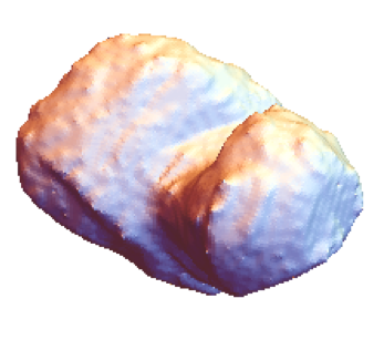
This image shows an example of a crude shape model generated using the silhouette carving method. The colours are the default settings used in the software tool mathematica. This silhouette carving approach was the first step in creating a shape model that could eventually be used for navigating around 67P/C-G. Credit: ESA
The next step was to identify landmarks on the surface of the comet that could be used to create a framework of reference positions. For the first shape models, the team identified, by hand, 30 landmarks — easily recognisable features such as pits, valleys, or bumps — to make ‘maplets’. These maplets are small, 3D high-resolution maps. The first maplets covered 500 m x 500 m with 10 m resolution, while during closest approach to the comet the maplets covered 100 m x 100 m with 1 m resolution.
The maplets are generated by stereophotoclinometry, a technique that uses stereo images of regions of the surface and finds slopes by examining the way the surface looks under different illumination conditions. Once the slopes are known then the surface height can be inferred.
These maplets were then projected onto the crude shape model to provide a more detailed shape model. For recent shape models the team now use about 1000 landmarks, which are automatically identified from NAVCAM images.
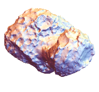
This fine-detail shape model is an example of one generated using the stereophotoclinometry method. This method was also used to generate the ESA shape model that was released today. Credit: ESA
The ESA NAVCAM shape model is a core tool used by the team to precisely navigate around 67P/C-G. Each day, the positions of landmarks are identified in the most recent NAVCAM images and are provided to the orbit determination team who use this information to establish the position of the spacecraft with respect to the comet, and to plot the new trajectory. The orbit details are updated twice a week and are used by mission planners to devise the future orbits, and by the instrument scientists to plan their observations.
In addition to these operational aspects, a shape model is also an important tool for scientists analysing images and data from Rosetta. Such models can be used for calibrating data, studying changes on the surface, and for investigating the geology and morphology of the comet. The OSIRIS team have produced a number of shape models in the course of the past year which have been used by Rosetta scientists to select the landing site for Philae, and to determine physical properties of the comet, such as size, volume, and density, as well as measuring the rotation of the comet, its gravitational potential, and tracking changes on the surface.
And it’s not just people working directly on the mission who produce shape models. Mattias Malmer, an image processing expert and a space enthusiast, has developed a shape model based on publicly released NAVCAM images. This is accompanied by a ‘texture’ file that indicates the boundaries between the different geomorphological regions that scientists have identified on the comet.
Apart from the very specific operational or scientific applications that the Rosetta teams have for shape models, there are plenty of other uses for these models, such as printing your own 3D model of the comet or creating visualisation tools, such as the View Rosetta’s comet tool that is released today.
Update 30 November 2015: a new NAVCAM shape model was released on 30 November 2015.
Download the ESA shape models
The files for the ESA NAVCAM shape model, which was generated from NAVCAM images obtained during the close orbit phase in September and October last year, are available to download from here.
Files for an ESA NAVCAM shape model, including images taken by Rosetta’s NAVCAM up until late July 2015, and revealing parts of the comet’s southern hemisphere that were not included in earlier shape models, are available to download from here.
These models are licensed under a Creative Commons Attribution-ShareAlike 3.0 IGO License.
We hope you enjoy using the new shape model – do let us know if you’ve used it for your own projects, or if you have any questions about it, by writing in the comment box below.



Discussion: 7 comments
I know little about shape models– in general, if I want to do 3D-Printing, , which format would I want? And if I was doing 2D-paper printing for mapping, which would I want?
*QUOTE*
ESA NAVCAM Shape Model
Info: The model matches NAVCAM data gathered during the close orbit phase in Sept/Oct 2014
Download
OBJ File (151 MB)
WRL File (174.3 MB)
STL File (585.6 MB)
ROS File (248.1 MB)
*QUOTE*
–Bill
Bill, for 3d printing STL is most widely used followed by OBJ. I’m not sure about 2D printing. Hope that helps.
I’m interested in printing this model but would like some insight on the region that appears to be very smoothed compared to the rest of the shape model.
Does this region appear that way due to a lack of data (my guess) or is it genuinely shaped that way?
I’m referring to the region that appears in grey with no region name assigned as view on “View Rosetta’s comet” page.
The smooth parts on the southern parts of the comet are areas that where in total shadow at the time when these models where made. So it was not possible to reconstruct it properly.
If you compare my model with the ESA model you can see that those areas look very different. I decided to smooth my unknown areas. on the ESA model they Let the sillhouettes carve out an almost pyramidial shape. so it is just two ways of handling the same unknown.
In the near future there will be images released that show those areas lit with the first rays of the summer sun. I will update my model as soon as that happens.
Thanks, Jonah. That will get me started with working on 3-D.
–Bill
Thanks, Mattias! Looking forward to seeing your updated model and printing it out.
Regards
Hello…
The gravitational model of the comet is public?
Regards
David