This single frame NAVCAM image was taken on 6 March from a distance of 85.5 km from the centre of Comet 67P/C-G. The scale is 7.3 m/pixel and the frame measures 7.5 km across.
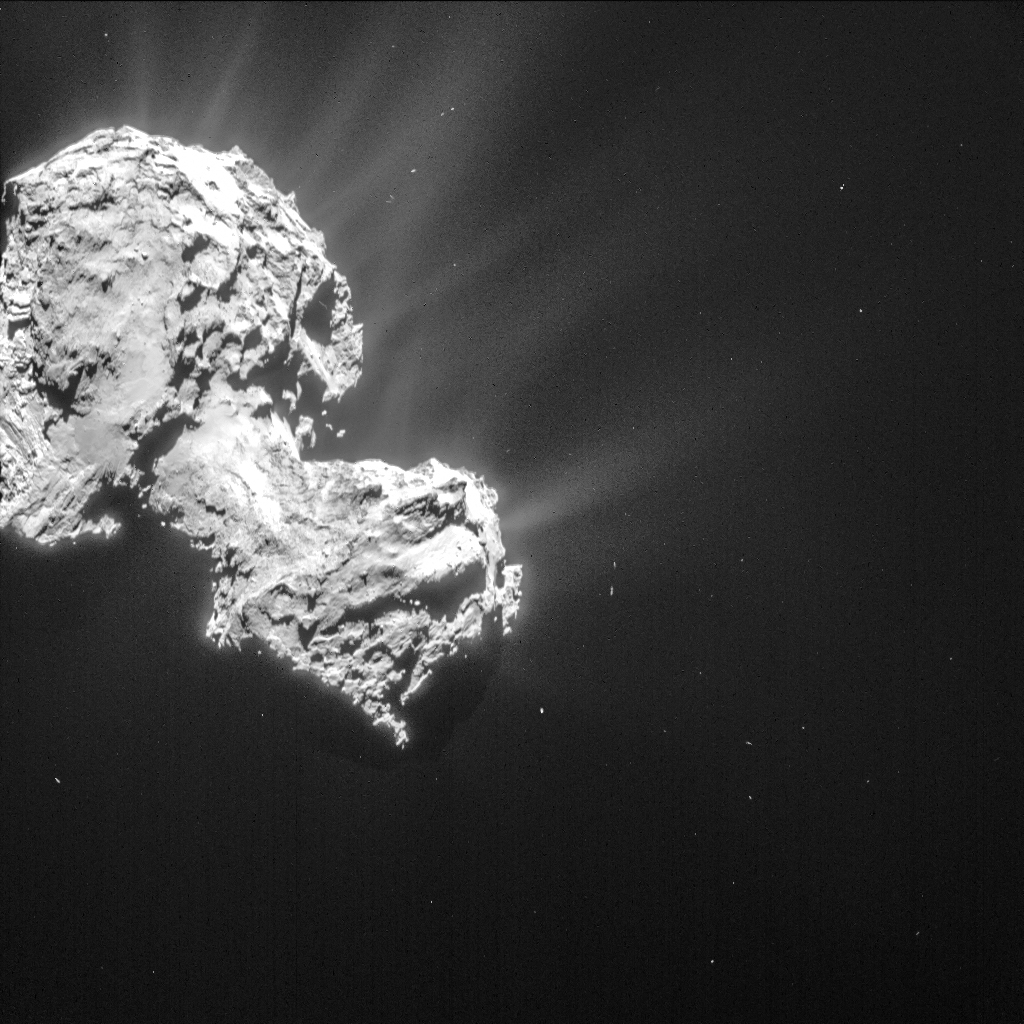
Single frame NAVCAM image of Comet 67P/C-G taken 6 March from a distance of 85.5 km to the comet centre. Credits: ESA/Rosetta/NAVCAM – CC BY-SA IGO 3.0
The image is deliberately offset from the centre because it was taken during a specific pointing for the Alice instrument. As described in a previous post, these Alice context images are currently slightly over-exposed on some parts of the comet, so we have again chosen to focus the processing on the activity.
Although taken on the same day as Monday’s CometWatch entry, six hours separate the images – roughly half a comet day. From this angle, not only do we see completely different surface regions, but also a different and perhaps more detailed perspective on the comet’s activity.
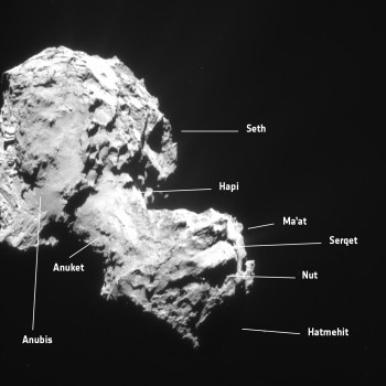 An annotated diagram is provided to guide the eye to different surface regions (the approximate boundaries are marked on the regional maps here and here).
On the small lobe, the small regions of Serqet and Nut can be seen. Serqet encompasses a sharp ridge and a flat smooth plain with a few boulders. Nut meanwhile, largely in Serqet’s shadow in this view, is a small depression with many boulders bordering the Ma’at region. The silhouette of the large Hatmehit depression is just visible at the far right.
The transition from Serqet through Anuket and onto the smooth neck – Hapi – can be traced by the change in topography and surface textures.
On the large lobe, the boundary between the smooth terrain of Anubis and the circular and semi-circular structures that define Seth is also apparent.
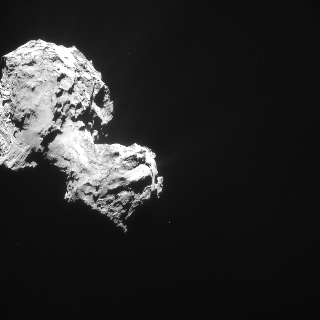
The original 1024 x 1024 pixel image is provided below:



Discussion: 37 comments
Thanks– the ALICE context NavCam images, with light processing to show the dust jets are a wonderful resource.
–Bill
First time didn’t post, so will try again. With more and more dust coming from P67, as this picture clearly indicates, if it is due to sublimation, then the dust must be more or less evenly mixed with the ice according to standard theory. And according to Gerald at least, there is four times more dust than ice by mass and 1.5 times more dust than ice by volume. So how did this happen? I’ve often wondered how nature could more or less evenly mix gas and dust in a vacuum? If P67 is mainly dust with a much lower percentage of frozen volatiles, it seems unlikely it would stay together for ANY passes by the sun as there must be little holding it together. Yet comets have even passed through the sun’s heliosphere and survived the incredible heat. But regardless, I can’t conceive dust and gas just coming together in a vacuum. Seems things tend to disperse in a vacuum, and especially gas. You certainly don’t see all the gas and dust coming off P67 reforming anywhere, for example. And saying that it would or could happen over millions of years doesn’t really answer why it would do this, or how. So, EXACTLY how did a bunch of dust and gas floating around in the vacuum of space coalesce into a more or less solid comet? What makes gas come together in a vacuum in the first place? And was the gas in a gas form when it mixed up with the dust, and if so, how did it combine evenly with the dust, what held the two together, and why did it suddenly become frozen? And if it was already frozen, how could it have become evenly mixed with the dust? Or was it a liquid when it mixed evenly with the dust? This seems the most likely regarding even mixing, but hardly would happen in a cold vacuum. So perhaps those more knowledgeable could walk me through the scenario step by step.
Sonereign Slave,
Very good observations and questions. Well thought out and presented.
If the ice was liquid when it mixed with the dust it could have combined to form molecules. These molecules then may have been attracted to each other enough to form larger bodies.
The question that comes to mind is, are the elements that are being ejected from 67P being split apart by solar wind and/or plasma into the constituent parts that were originally attracted to each other? Someone more knowledgable than I would know the answer to this question.
But your main question about how the ice and dust originally came together is at the top of my list of questions also.
67P’s perihelion is 1.24AU; it doesnt go anywhere near the heliosphere, it remains outside the earths orbit.
A combination of gravity & chemisorption etc has been extensively & quantitatively modelled to give a *basic* understanding of the coallescence, go read the literature.
Ive no doubt there is a vast amount of detail to understand, but no problem with the basic process.
How did it come together in the first place? – gravity.
On a small scale, at 300K or so, no, none of this would happen.
But on a huge, cold scale gravity does matter & other processes operate.
Yes, the volatiles will largely have been monomolecular; no one suggests liquid!
At low temperatures whilst molecules struggle to form condensation nuclii; they will readily deposit on the surface of dust grains, which grow an outer ‘shell’. In fact even at 300K, the walls of an unbaked vacuum chamber are covered in absorbed water, & the residual gas in the chamber is primarily water, not air. You have to bake at 3-400C to get the water off the walls.
So you will tend to get solid (silicate etc) nuclii covered in a shell of volatiles. They then coallesce both because they can ‘stick’ in low velocity collisions & under gravity. This rather naturally leads to an initially fine scale mixed body.
Surface layers of comets then undergo a variety of fractionation processes on near sun passes, leading to an involatile enriched surface.
Incidentally comets can survive near sun passes pretty much in the same way I can run my insulating gloved hand through a flame; its an issue of the thermal conductivity & thermal mass (ie, thermal time constants) & indeed not all comets do survive.
Hi Harvey. “…volatiles will largely have been monomolecular”.
Stardust not mono, in fact stardust should came in all sizes, and this is key to gas trapping. Am I wrong?
‘Volatiles’ in this context primarily means H2O, CO & CO2. These willl be mainly monomolecular under the very low pressure conditions of a primordial gas cloud. Its conceivable I guess that, especially for water, there might be molecular aggregates, I’d need to look into that further. But generally condensation onto a solid (say silicate dust grain) nucleus appears more likley; the pressure in space is so low that ‘ice’ sublimes & returns to its gaseous monomolecular state, whereas it binds more strongly to solid surfaces (in very thin layers.)
Anyone using ultra high vacumm apparatus, as I do, is painfully aware of this. We have to bake to 3-400C to get the trapped water off the surface.
Harvey, I think the key word in your explanations is “modeled.” And yes, modeling can be fun and can make pretty much anything sound logical and reasonable based on an untold number of what if’s and could be’s and other suppositions, but a model is only as good as all those what if’s you’re feeding into it. Anyway, your explanation still begs the question of how gravity brings together individual dust particles. How did gravity attract the very first two dust particles of a comet nucleus together? And if you’re talking about there needing to be vast space for gravity to work to form the comet, seems the nucleus’ gravitational reach at whatever stage of development wouldn’t be anywhere near great enough to attract the needed volume of dust distributed in a vast area, and given the size of P67, it must have been very vast. Unless we’re talking about all that dust forming one big super-comet with enough gravitational force to attract large volumes of dust, and that comets are broken-off chunks of that, though that seems to contradict many other findings. But if you’re saying that this comet formed independently more or less as-is size wise, taking into account loss from sun passes, it seems incredibly unlikely that the extremely weak force of gravity could account for gathering together all that dust spread out over a vast area. So again, EXACTLY how did it form, step by step, according to your models and “other processes?”
See my other post re models; you appear to have a totally false view of what they are and how they are developed and used.
You have a #model’ in your head of two particular dust grains, how does gravity stick them together.
Its a totally inadequate model; you have to consider the whole cloud.
Any local positive density fluctuation tends to grown under the effects of gravity; its unstable. So the local density rises further. As the density rises collision rates rise. And a few stick. No two particular particles significantly are attracted to each other by gravity; gravity increases the particle density & increases the collision rate. You have to think on a large scale, statistical ensemble scale.
That’s what modeling does; tells you if your mechanisms are consistent with observation; tells you what to measure to check your model; helps you understand what further physics needs to be included, what approximations are valid or invalid. Its not some vague play-about, its a detailed, careful, repeatedly tested tool to understand things. Without models you just have isolated data, at different places, about different, apparently unconnected things. With it you have a coherent, *testable* description of the world.
A QUANTITATIVE test, not just the vague ramblings we often get here.
Am well aware of what modeling is, its benefits, and its many drawbacks and limitations. And models are very poor substitutes for experimentation, as you no doubt know. And there’s the rub. Everything you present regarding the formation of this comet is *untestable*, it’s pure speculation, or more like it a structure of speculations based upon many other speculations. I’ve read many of the models about comet formation and haven’t found one yet that really explains, IN DETAIL, the step by step processes and mechanisms of how dust and gas in a vacuum condense into a comet. And you still haven’t answered that question either, so perhaps you can link me to a study that does. But it should be pointed out that your assertions about how this comet formed are WAY beyond any experimentation that can properly approximate those conditions (dust and gas condensing via gravity into many individual cometary bodies within the vast vacuum of space). And all kinds of things can be imagined and modeled and be shown to reflect reality, but without experimentation, it’s still all just untested speculation, and should not be simply bought hook-line-and sinker and repeated over and over as if it were in fact…fact. I mean, doesn’t it seem strange to you that there aren’t any other models about comet formation being presented and seriously considered, which would at least suggest an open minded skepticism and ongoing inquiry? Once one is overly attached to a model, everything tends to be interpreted according to that model, and as long as its remains experimentally untestable, it gets to continue to live and grow beyond all scientific accountability.
Space Labs are an urgent need, Harvey and Sovereign Slave.
Unfortunately we can only conduct experiments now.
No one has provided us with a time machine to conduct experiments 4.5 billion years ago.
So all we can do is measure now, & look for consistency with out models of what that implies then.
And that’s exactly what we are doing with Rosetta, & previous space based & earth based measurements.
As I’ve said previously, Im not a supporter of any ‘model’ professionally. But I am a professional scientist/engineer.
What I see suggests that the conventional models make *broad* sense, with huge amounts of detail to fill in.
(Though personally I’m probably more interested in the ‘now’ than what it implies ‘then’, but that just my interests.)
The ‘competing models’ don’t even exist basically in a quatitative sense, & the bits & pieces of verbal descrption frequently defy well etablished laws & obvious observations. Since they are never quantified or described analytically, they are hard to disprove. Its easy to throw bricks at a detailed quantitative model; rather harder to tear down a verbal smokescreen.
Some of the assertions on the main supporting web site for this stuff, & the presentations at their main conference, are simply laughable. This does not exactly inspire confidence.
*WHEN* they present a coherent model consistent with observation & the laws of physics I’d be delighted to examine its merits. But I dont think they ever will, because it doesn’t look possible to do so.
Well, as you say, no one has a time machine, and yet how much of cosmology is based on and conforms itself to the notion of the big bang theory and other early formation theories, which when you boil it all down, are basically creation myths. When over and over data is used to try to support the consensus explanation of origins, whether of the universe, our solar system, or this comet, it immediately veers into unsubstantiated dogma that is simply repeated as indisputable fact. And in my opinion at least, too many of the conventional models don’t make any sense at all, are contradictory within themselves, contradictory to other established laws of physics, contradictory to plain logic and to every day observation of the world of nature, and by and large remain totally divorced from scientific method. And when I was referring to competing models, I meant competing models being actively generated from within conventional cosmology. You don’t see this really happening though, or not much at least. To be frank, you see a mindset which you in fact reflect. You come across as already having the big answers, yes there are surprises and things that are difficult to explain, but we’re basically right and therefore by definition anything else is pretty much wrong. But as you say, there is a huge amount of detail (scientific data) to fill in, and instead of open minded investigation and a mindset of critical doubt and an honest questioning of everything, all data and observations are used to reinforce pre-determined beliefs and theories that enjoy a much too comfortable consensus.
I’m not sure why you say *no one* suggests liquids. With the discovery, on stardust, of CAI (Calcium/Aluminium Intrusions) the suggestion of radioactive decay of Al 34 is that it would cause internal melting and energy inside comets for up to millions of years.
That could permanently alter the internal morphology of comets.
Internally I guess liquids might be possible., forming after a large body has condensed. The discussion was about a low density primordial cloud and how it collapses; liquids are not possible there.
“So, EXACTLY how did a bunch of dust and gas floating around in the vacuum of space coalesce into a more or less solid comet?”
So we are talking finally, Sovereing Slave.
First thing. I presume ‘Coraline’ is not primigenial material. What we see is the result of great, great amount of transformation and time.
We need to think of a theoretical, small, faint, solids made object, let’s call it ‘cometesimal’…
So, EXACTLY how many ways occur to you that a cometesimal could come to be? Floating around in the vacuum of space?
Second thing. Just as stars have special places to be born. Cometesimals too. You have to think of the nothing. Better said, the almost nothing.
“So, EXACTLY how did a bunch of dust and gas floating around in the vacuum of space coalesce into a more or less solid comet?”
Given time, things stick.
https://arxiv.org/abs/1306.3672
https://arxiv.org/abs/1302.3755
” What makes gas come together in a vacuum in the first place? And was the gas in a gas form when it mixed up with the dust, ”
The volatiles (NH3, CO, CO2, H2O) are firstly in a vapour phase, but at some radius from a protostar, there is a preference for the molecules to condense onto any nearby grain – the binding energy of adhesion being sufficiently high that the ambient temperature cannot desorb that molecule.
This is the origin of the Antoine equation. At some temperature, a given material prefers to be a solid. As simple as that. So – one has icy dust grains at some distance from the early sun – with the difference species condensing at different radii.
The grains cohere – given time. One makes boulders, and then gravitational perturbations cause some of these Keplerian orbits to become nearly hyperbolic.
Voila.
Comets.
This is the canonical view – and I know of no data that gainsays it.
Well, this in an extreme 3D update!
Wordless. Sorry.
I hesitate to talk about where the dust columns are coming from, because they are only visible due the right phase angle. These two images are from totally different angles and both show no columns obviously coming from the neck region, the previously most active region. The reflectance spectra with a bluer slope indicating water ice closer to the surface in the Hapi region suggests this “easy” to sublimate water has been removed and the insulating effect of the dust is now preventing sublimation of the sub-surface ice.
The more prominent features in the activity seem to be associated with outcrops with less dust coverage. The general low level dust halo is now around the whole illuminated surface and is gradually increasing in height and density. A sign the solar energy reaching the the subsurface volatiles is increasing.
The view of the Anubis region is fascinating, the whole side of the comet looks like its melted and refrozen. Reminiscent of a frozen waterfall or lava flow. 67P continues to unveil yet more mysterious surface morphology.
Robin
Regarding your observations of Anubis, I also recall you saying once that the bottom part looked like a glacier. I think I have the explanation for this and the other strange morphology. It’s another missing slab as described towards the end of this post:
https://scute1133site.wordpress.com
This is a very interesting image Emily and thank you for it. It is striking that each jet appears to be exactly normal to the bit of surface it originates from. This is a characteristic of electric discharges from surfaces. The consistent width ( or small range of jet widths) is interesting too, particularly as these widths appear to be in the range of 100 metres or so even at the point of initiation, and that width. appears fairly constant out to a distance of a kilometre or two.
The glow density is also consistent from jet to jet and it is noticeable that the brightness ( at this exposure) falls off quite abruptly at about a kilometre out from the nucleus surface.
Not the characteristics at all that would be expected of gas pressure jets issuing from random surface openings and randomly picking up varying amounts of dust from the surface.
Is there a cliff falling down from Anubis onto Atum? Or does it only seem like that because of the angle of view?
It is a characteristic of *high conductivity* surfaces that the electric field must be near normal to it; *at the surface*. The boundary condition is that the tangential E is zero for infinite conductivity. However *no* such constraint exists for an insulating surface. For intermediate cases, the surface conductivity will constrain the field to some degree; however all models of the surface suggested to date are high resistivity/low conductivity & the field is unconstrained. There is no valid comparison to a glow discharge on a *metal*, high conductivity electrode.
In addition, this is a boundary condition; it applies *at the surface only*. If you have two concentric spheres, the fields remain normal everywhere. If you have a sphere and a plane, the fields are normal everywhere *at the surfaces*, & ‘bend round’ from the side of the sphere which is not opposite the plane, quite rapidly deviating from normal to the surface.
We are told the ‘other electrode’ is the sun, which certainly does not represent a concentric shell around 67P, so the situation is more like the second case than the first (though here it will be distorted by the effects of the weak interplanetary magnetic field.)
Glow discharges have a very strong tendency to become non uniform of their own accord, especially in the presence of electron attaching species such as oxygen. Gas laser designers used to spend an awful lot of effort avoiding such instabilities. In fact it would be just as surprising if a glow discharge was uniform as a cloud of dust.
The question about dust and volatiles coming together in the near-emptiness of space — there are papers out there on the internet that discuss models for how that happens.
Comets like 67P are believed to have formed in the early, early solar system; where there was a higher density of material than the interstellar medium; even so, it’s all about waiting long enough.
Try an internet search, like “comet formation pdf” — the first thing that came up for me was this link:
https://www.lpi.usra.edu/publications/books/geologyTerraPlanets/2_AsteroidsCometsPlanetFormation.pdf
There’s plenty of stuff out there to look through, so you don’t have take the first opinion you see.
A textbook I got out of the local university library is _Comets II_ with seven chapters discussing our best understanding of how comets arise, starting from the interstellar medium and going through the stages of the early solar system.
I am having so much fun doing these searches and turning up way more stuff to read than I have time to get to. I’ve learned so much more about comets in the last few months, just doing queries like the one above.
Hi Judy, thanks for the link and comments, and agreed, comets are fascinating and it’s been great fun learning more about them and debating them. If anything has become clear over Rosetta’s time with P67, it’s that very little is actually clear about this comet, oh, and also that debates require little true facts to rage on. However, my observation is that none of the theories proposed so far, whether sticky dust and gravity or EU or stretch theory, really stand up to detailed questioning, and the more detailed the questions, the more apparent the number of assumptions supporting whatever theory. That doesn’t mean that one of the theories isn’t true, just that they should be met with much more skepticism than most of their advocates possess, myself included no doubt. And yes, I’ve read some of the papers you mention, but I’ve not found one yet that goes into real detail about how whatever is being proposed really happened, they just jump to the assumption that it did and go from there. But the devil is indeed in the details, as any good lawyer will tell you.
Personally I rather think ‘good lawyer’ is an oxymoron 🙂
However a more pertinent point.
The complaints of ‘gaps in’, ‘assumptions’ etc etc are indeed sometimes justified. But they also rather frequently are simply a result of the complainant reading scientific papers without adequate background understanding. What they see as a gap or assumption, is simply well understood common knowledge to the audience for whom the paper was written. It is inevitable that such assumptions of prior knowledge are made in writing a paper, or they would all be ridiculously long and repetitive.
It might be worth some of the commentators here considering that point occasionally.
To your first point I concede. And there’s no doubt validity to your second point (maybe not as much validity as in your first point), but can’t help but wonder if it’s also often the case that you could substitute “knowledge” for “assumption” in your post above, and it would read with as much validity as well.
“knowledge” with “assumption” that is.
As I said, *sometimes* the criticism is valid.
But here I see a great deal of evidence of the ‘little knowledge is a dangerous thing’ problem. It’s frequently very obvious the underlying physics knowledge is, shall we say, weak.
I suspect there is also a problem of access behind some of this; a few of us have the privelege of having full access to most of the literature. Others quite often clearly only have an abstract, & the combination of limited background & abstract only can be very missleading indeed.
(Whether everyone should have open access is a separate debate engendering much heat in academia/publishing currently. In general I support open access, but I’m not entirely convinced there is a fully convincing model of how to do it right now.)
When you state earlier above that basically cosmology has “huge amounts of detail to fill in,” and connect that with your statement that “little knowledge is a dangerous thing,” you hit the nail on the head.
As I suspect you know, the ‘little knowledge’ I was refering to is little knowledge of basic physics.
I’m much less ‘certain’ of the history of how these things formed; something overturning the current views could maybe happen; but it *needs to respect the relevant laws of physics*, & be consistent with the data; all the data, not cherry pick.
In contrast, the ‘discharge’stuff is utterly at variance with physics & observation & has no credibility whatever.
Harvey: Now that we have blogs like this one, they inspire people to participate. For their background they read up whatever literature is available easily off the net. This comes with its own problems, because you can’t compress all the work beginning planetary scientists do, going through textbooks, building models, working out the exercises and developing their intuition, into one or two brief articles on the net.
One also needs some history of the subject. When a paper says “dirty snowball” they are referring to a technical model (originally proposed by Whipple). But when I read “dirty snowball” I form a mental image based on my own intuitions. Then I am amazed when I see pictures of C-G and I ask, where is the snow? Only when you look at what is known about comets, you realize that all we have for the vast majority of comets is photographic and spectrographic data, from which Whipple had inferred a mixture of “dirt” and “snow” (ices). From that broad a perspective his model is far from refuted yet.
There is a second-order problem which affects most of cosmology, and which is hard to realize. There are so many theories regarding formation of this or that object, or indeed the entire universe, but at the level of historical time we have not really seen anything forming. So every such theory has to based on careful modelling and inference, because quite literally there is nothing to see.
It is difficult to bridge the gaps among people having varying backgrounds in science and to communicate, but on the other hand it is refreshing to find oneself engaged in discussion with this variety of people, and I like this blog for providing such opportunities to all of us.
And if you want to try to reconcile basic physics with black holes, be my guest.
Sovereign slave: Perhaps you may want to read Stephen Hawking, who has some of the simplest explanations of black holes I have read. Chandrasekhar’s textbook on black holes is what you should read if you have some knowledge of basic physics.
Judy: I don’t think websearch is a good idea to find out about comets, or their formation. The main problem is that we know very little about comets and can only speculate about their formation. We don’t have any idea how planets form yet.
We talk about the Oort cloud but it is a theoretical construction to explain where some comets come from. There are plenty of ideas floating around because we don’t even have the data to refute them. Websearch gives us a lot of information but it is not verified information in any sense.
In that sense Rosetta and Philae are going to be pioneers. At least we are not going to be like Galileo and Schiaparelli, calling features “seas” and “canals” because those are what earth features they look like. Quite possibly, when the mission is over and all the data is analyzed, several theories can be junked. It is not a matter of seeing one picture and jumping to the defense (or offense) of your favourite theory. Looking at all the pictures (and all the other data) and retaining what is consistent is going to take a lot of work over hundreds, if not thousands, of research papers, reviewed by peers who are competent as well as skeptical that you may have jumped too far ahead in your conclusions.
I am not discouraging your efforts at finding out more. Indeed I am enjoying reading and learning a lot since last August. But even compared to planets, we start from much more poverty of knowledge when it comes to comets. I suspect in five years the textbooks will be completely rewritten.
Kamal