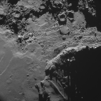
This four-image NAVCAM montage comprises images taken on 18 October from a distance of 9.9 km from the centre of Comet 67P/C-G – about 7.9 km from the surface, not long after the image published Monday was taken. The four 1024 x 1024 pixel images making up the montage are provided at the end of this post. Assuming the 7.9 km distance, the image scale is about 67 cm/pixel, so each 1024 x1024 pixel frame is about 690 m across.
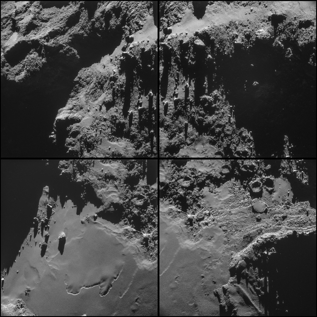
Comet 67P/C-G on 18 October, from a distance of 9.9 km from the centre of the comet.
Credits: ESA/Rosetta/NAVCAM
In this image, we’re looking at the underside of the larger lobe of Comet 67P/C-G, which provides another look at boulder Cheops (lower left frame; see here and here for previous views) and a much more detailed look at the feature-rich surrounding terrain.
Numerous circular depressions can be seen towards the centre of the region, some with rather well-defined rims and smooth floors. While some craters and pits on 67P/C-G may be direct tracers of active locations, it is also expected that sublimation of volatiles from beneath the surface dust could induce collapse of the overlying area into pits. Of course, based on these images alone, alternative interpretations cannot be ruled out. Some circular depressions may be evidence of past impact cratering events or perhaps fine-grained material filled in some previously existing depressions, with the surrounding material later eroded away to give the appearance of a raised rim.
The lower-right frame also hosts a wealth of other interesting features, such as the exposed cliff faces bearing cross-cutting scars that run in numerous directions. On top of this feature, in the lower centre of the frame, an area of overlying dust appears to have been shaped into a surprisingly linear form – perhaps aided by underlying topography. Moving left from the largest exposed cliff face in the bottom right corner of this frame, it is possible to trace the outline of another ‘ledge’ emerging from the dusty covering. If this is indeed an erosive process, and if it can be applied to this entire scene, then perhaps the long curved depression that takes centre-stage in the lower left frame is also an expression of the topography that lies beneath. Alternatively, different rates of erosion/sublimation could be responsible for carving out these shapes in the surface material, independent of what is below.
Meanwhile, back towards the top of the lower right frame, rougher textures similar to those seen in the cliff faces are interspersed with the smoother material, boulders occasionally dotted in a seemingly random fashion. More boulders are visible towards the top of the image, casting long shadows onto the scenery below.


Discussion: 87 comments
Incredible! In fact, Incroyable! What a wonderful little world, and what a great mission! I hpe we will see some annotated images or maps with other feature names soon.
Thinking about that surfaces looking like ‘dusted off’ surfaces.
Who said here first about ‘areo-gels’?
That could be the best description.
That could explain the ‘stealth’ of ice too.
Aero-gel on sublimating leaves a ‘stealth’ matrix over it.
yellowstone
We must get used to the noise from the navcam’s ccd: Vertical two pixel bars, two-by-two checkerboards, etc. Removing that, still find objects flying. Oh! This place must be the holiday resort: Geysers everywhere?
Hi
have you simulated the effect of the dust that will com from the philae landing? I mean, it may happen a lot of dust coming from the touchdown…is that right?
Not likely to be a problem with dust. In vacuum and low gravity the eventual dust will leave at flat trajectories.
If the surface contains tholins (tar) this might have a shape that is not like dust at all.
All pictures so far does not clearly indicate dust, the pictures the public has been able to get in sight so far shows structures on the smoothest surfaces and the resolution was 1/4 m2 at the best. The best pictures ESA has have a resolution of better then 1/40 m2 that is 10 times better. On top of this ESA can indicate several other properties on the surface with the filter wheel set in the Osiris camera.
The ‘active’ zones are ‘un-dusting’ themselves.
The surface is ‘drawing’ itself on the upper dust ‘carpet’ (active zones). Gas probably main agent.
Backing off in this ‘agent’ thing. Remember ‘drawings’ over ‘heavy’ dust depositions in ‘active’ craters.
I think I’ve decided they are deposited by the gas plumes from the surrounding cliffs firing across the already Laktritz covered floor of the “crater” Logan. Just as the mounds and dunes near cliff edges are created. No need to find a different “agent”. The gas plumes don’t have to go straight up do they.
I spotted this some time ago at the base of a cliff in the neck area. The demarcation between exposed subsurface and dust blanket, is really sharp. Now we can see why and how. The rubble strewn area to the right of image 4, the surface blanket looks like snow melting, all patchy, where thicker drifts and mounds take longer to melt. These dust mounds must be where all the dust has been “blown” and collected into quiet zones, so these little pockets take longer to be dispersed.
The chimneys I think are the “smoking guns” for the body penetrating impacts we discussed. The molten ice stuff coming out would build a wall as it immediately freezes on reaching the surface. Frozen and semi frozen ice would slowly fall back down. By the time it reaches the surface the comet has rotated so one side of the caldera has a lot more ice deposited on it. The liquid in the caldera will soon level and freeze once the gas pressure is released and the “ice lava” tube becomes blocked. This core and crater floor will have far fewer volatile ices and gases in it making it a lot less active than the surrounding surface, hence the build up of Laktritz. As the higher side of the icy crater rim takes longer to erode we are left with lots of semicircular cliffs beside flat areas.
The overturned cups are more recent eruptions where less of the crater rim has eroded. The huge flat Star Wars Landing Zone near site C. Is perched on top of huge steep cliffs, the wall of frozen ices that built up as the cryovolcano was erupting. Then we see the partially eroded rim as the cliffs round the flat area. The little cup volcanos show that an overhang actually builds up on the taller side of the rim, so this overhang eventually collapses into the crater, hence the pile of rubble only on one side of the crater. Something that is seen in nearly all the craters.
If the refrozen ices form an amorphous solid like glass, as lava does to make basalt on Earth, we get the smooth solid material full of cracks and fissures we s most commonly on the tops of the lobes. A different composition and slower flow rate would give lumpy, rubble “ice lava, (top left Image 2).. Ices with more gases in them would give a more pumice type material when it freezes, full of holes and tunnels, (Philae landing site image). A different composite of more dense volatile ices give a material like “pillow lava”, which can also be seen in image 2 as the flat topped bulges top middle.
How far this analogy can be used in actuality, I have no idea. No one else does either, since no one has seen cryovolcanism up close before, only on flyby pictures from thousands of Kilometres away. The laws of physics don’t change and the behaviour of molten fluids on freezing is a pretty well understood phenomenon. The low gravity is the big difference, though it seems to make little difference on the Moon and Mars.
Other brands of over enthusiastic speculation are available. 🙂
@Robin. “The molten ice stuff coming out would build a wall as it immediately freezes on reaching the surface.”
By “molten ice” you presumably mean liquid water? What is the necessarily intense internal source of heat which is creating your “cryovolcanos”?
In any case, there is absolutely no ice at the surface of the comet, so those walls are not ice.
“…The molten ice stuff coming out would build a wall as it immediately freezes on reaching the surface.” You are talking about high pressure and temperature.
“… low gravity is the big difference, though it seems to make little difference on the Moon and Mars.”
Would like to differ from you on this, Robin 🙂
I should perhaps have qualified that by saying “little difference qualitatively” and yes there is a big difference between the “low” gravity of the Moon and the “ultra low” gravity of 67P.
OK. Just admitting for some of them. Some areas looks ‘side’ dusted.
Following Thomas:
liquid water would mean pressure levels in the mbar range which is presumably quite large, no? or do you have something else in mind?.
And even if the putative liquid water DID make it to the surface of the comet and immediately froze on arrival, then the resulting water ice would have been observed. It hasn’t. The theory is thus falsified.
Agreed Thomas, if the surface remained unchanged. The dark “coating” of organics and dust covering the surface, which accumulates over time, hides the ice from external observation.
Or it could just be Rock, in which case significantly larger amounts of energy are involved. Less plausible, but still a viable option. Just as electric discharges acting on volatile ices instead of Rock is viable and a possible source of energy for cryovolcanism. This comet could be a chunk of the surface of some icy moon blasted off in the manner EU theory describes.
‘collapsed by gravity’ dunes at Bottom Left of
https://www.esa.int/var/esa/storage/images/esa_multimedia/images/2014/10/comet_on_18_october_b_navcam/14994318-1-eng-GB/Comet_on_18_October_b_NavCam.jpg
Pixel 577,1913
The last pictures in this serie is the on that i like the best due to the nice impact craters. Most of them as expected but one of them filled up to its rim with Lakritze. On earth Lakritze is black, soft and tastes very specific. On the comet its behaving like cryogenic-phase-change-material tasting overfilled-vacuum-cleaner-bag.
These set of images are the best delivered so far.
Liquorice is english for the german Laktritz and it is the strange soft, black, magma-like material that are the flat dust-like blankets. It is not dust and not ice and not liquid, its Liquorice and its very black.
Such wondrous and marvelous features! And that’s only one little dusty duckie in one lonely star system. i like space 🙂
Most dusty areas show some form of pattern (intricate lines, a bit like some tree bark, or scales or thread pattern, for lack of better wording).
Similar things were visible near the “dunes” and on the neck.
Are these image artifact or real “structures”?
Quit ‘big’ by now (in pixels) to be noise or artifacts.
Started looking at these images 4 hours ago. Absolutely packed full of information about what is going on. As Emily points out image 4 is just full of interesting nuggets. There is no doubt about gas plumes and little dust jets now, there are loads of them.
As Logan says the sublimation of the sub surface layer is “blowing” the dust away from the underlying surface. We can see how the blanket of “Laktritz” reflects the underlying surface topology.
That linear ledge is just like a brick wall, amazingly straight and level. There are clear layers seen here sipping down to the plain. Another lower layer is just showing through in places as the “Laktritz”, (I like that word), is swept away. Directly above the end of the straight ledge, about a third of the way up is a little white “Stone” with a forked dusty jet highlighted by the dark background.
The weirdest features are the “cups” on their sides and the circular raised mounds covered in “Laktritz” while all around is bare. The two joined “cups” at the top of image 4, are producing a large amount of gas. The image is very distorted and pixelated right above them. They are like smoking “chimneys”. I think Logan coined that allusion. On the flat bits of a couple of the “cups”, little dusty sprites can be seen.
One thought, the mosaic image might be better the other way up, with Cheops at the top. Most of the image is running down the side of the big lobe towards the head. Cheops is at the bottom of a slope that starts where the squiggly feature is. This squiggly feature appears to be where the underlying layer of the plain has cracked and dropped slightly, leaving a 3 or 4 metre high scarp, the light bit. The edge of this scarp is so totally sharp, I think this must have been a recent event, no evidence of erosion of the Laktritz layer can be seen at all. The lower edge does show signs of dust being swept into mounds along its edge, the “freshly(?)” exposed cliff presumably sublimating rapidly.
P.S. Bob the Builder you left your saucepan behind when you were building that brick wall. Just by that little stool you sat and ate your lunch on.
How can you say that there is definitely sublimation? The top of image four is no more pixelated than anywhere else unless I’m looking at the wrong area. How can those round crater like features with raised rims and smooth, flat floorsbe collapsed pockets of gas? Where is the rubble on the inside?
With the recent confirmation of Cassini measuring a negatively charged Hyperion, I believe the obvious erosion should be considered with electromagnetic processes. Comet Hyutake proved that charge exchange occurs so why cling on to the sublimation theory when it isn’t needed? Just as water is produced on the moon via the solar wind, water can be formed in the coma. All of the cometary phenomena and surface features can be explained through charge exchange and electrochemistry. They can also be tested here on earth in a lab, as plasma physics is scalable. Sublimation of hidden interior ices is not necessary.
Electromagnetic or not but at least electrostatic as solar wind and hard radiation does create and release electric charges. Plasma is in the vicinity and sublimation is there as well as the poor vacuum almost demands this. Adhesion and other forces and processes also add to the soup.
The gravity is not the dominant force on this comet so the other stuff play a great role and on top of it all comes the timescale that we humans not really can grasp.
To simulate this on earth is far beyond our capacity. If we are lucky and a bunch of scientists can strip of their protectionism an try out some joint venture behaviour then we might be able to understand what is going on.
How our solar system was created is easier to watch with telescopes in our neighbourhood where a lot of star systems are created continuously.
I opened an old vacuum tube radio from 1955 and there is a bit of high voltage in those devices, just about 450 VDC at maximum. Some heat is produced an this creates a smooth air flow without fans.
The dust inside this radio was collected over these almost 60 years and sitting all over the place in a cm thick layer where the high voltage was present an at least 3 mm thick on “cold” places.This dust was lumped together and very stable.
On the comet it is possible that elecrtostatic charges reach magnitudes of higher levels and the timescale is enormously larger. This is then clear that in an ultra low gravity matter can move around in quite large amounts.
Now if the surface is to some extent semi conductive (carbon), but not in an uniformly shape, divided by high insulation patches and streaks (sublimated ices), it might be possible to transport matter in a way that patterns occurs. If the material transported changes its properties during this process, from insulating to semiconducting and the other way around, due to radiation, shade and whatever, it would almost look as if it had a purpose.
😉
In a very small scale there is a phenomena that i stumbled over a few times playing with sub kilovolt components on printed circuit boards. It is called tin migration and is a bit unpleasant as it creates short circuits in electronics.
The process is that on the circuit board that is of a high insulation material some components are soldered to its tin covered islands and a voltage of at least 300 VDC is applied, the tin is starting to crawl over the surface in tiny fingers until making contact with its opponent and create a short circuit, this process is rather fast and it is only to prevent by increased distance and coatings plus no lead-free tin.
It would not surprise me if on this comet something similar could be going on, if voltages are high enough and some substances are semi-conductive. The vacuum is a great place to build up huge voltages due to a lot of processes. Charged particles are present and if streamers are getting ionized some currents might flow in those antennas. How about piezoelectricity in the neck region? All experiments with equipments on board this mission is not for display yet and i frankly doubt that we ever will get a hold on the source date. Most likely only some of the results that fit the PR purpose will be on display.
Scanning pictures of small moons of our larger planets indicate a lot of image manipulation to pronounce spectacularity.
Yeh! Cometstalker a work of genius that post. Masterful extrapolation from minimal data. It’s so good I hope its true.
Glad to see the start of long-awaited recognition of any sort of electrical activity on the comet. Rather than “static” electricity, however, those amazing “searchlights” from the neck region, plus all the smaller jets shooting perpendicularly up from all over the other surfaces of the comet point not to static but to extremely ACTIVE electricity. It is this which has produced the extreme heat which in turn has apparently melted then vitrified (on cooling) many of the comet’s rocky outcrops to form those melted-chocolate-looking smooth areas we’re seeing everywhere.
In vacuum you don’t need continuity to have flow. micro particles acts as ‘carriers’ transporting the charges. Very long distances at times. Impeding myself of ion chatting. Quite interesting thread.
Hi,
Why some names in space conquest are egyptian’s names?
Thanks!
Best.
One suggestion. Placing a scale on the image may help viewer to know the size of objects.
It is readable at the very beginning in this blog that the size of each frame is about 690 meter square. It is up to you to estimate the rest. A tip is to use a ruler and calculator and in some image processing SW this is included.
ICE stitch: https://www.pictureshack.us/images/49436_ESA_Rosetta_NAVCAM_141018_stitch.jpg
Absolutely amazing photos! With the gravity so low, if one was standing on the surface, it should be possible to pick up some of the large bolders and throw them;) Do you think the bolders will move around on the surface when it passes near perihelion? I hope none roll over Philea.
What an astounding little world! Aeolian processes without strong winds and deflationary processes with a barely sensible atmosphere. The more we see, the more questions we have!
Here is a first approximation montage of Navcam sequence of the area informally named the “Giza Plain”, formerly known as the “North Polar Plain”, at a scale of 0.67 m/pixel, taken ion 18 October 14. Image source: ESA/Rosetta
https://univ.smugmug.com/Rosetta-Philae-Mission/Rosetta/i-7ntgqgF/0/L/ESA_Rosetta_NAVCAM_141018_A1–montage1–enh1-L.png
–Bill
Hi Bill. It¡s a very interesting spot, specially Top Center.
Oops. Where I said in the above post:
“the area informally named the “Giza Plain”, formerly known as the ‘North Polar Plain'”
I meant to say:
the area informally named the “Giza Plain”, formerly known as the “Equatorial Plain”,
🙂
–Bill
This whole mission and it’s results are just magnificent so far. Looking forward to the actual landing ! To me the accuracy of navigation and steering of Rosetta from such a distance and speeds are just mind blowing. I showed some of the mission video and photographs to my 9 year old son and although he probably compares this to some video-game or star wars movie he was genuinely impressed and curious. Big thanks again to the Rosetta team, ESA and all who made this possible !
Just imagine Hyperion, with all those craters worn down, you would see the bottom of the craters left, looking just like this…
No look at the striations and cross cleavage
could we be looking at compression and heat modification of methane hydrate to coal ?
https://en.wikipedia.org/wiki/Anthracite
On the cups, Bob the builder is even more untidy than I thought, and to leave a stool, where will he now sit for a cuppa.
The cups do indeed look like a smoking gun, but the question is what caused the smoke.
I dont think they are resulting from impact, thet are mostly in pairs, so how would that work?
Also, with 2 impacts happening together right next to each other, why such a thin wall between them? especially if there is heat from impact, these thin stuctures, if they are ice would melt, giving us just an elongated depression. Even then you need a method for all those strikes to be perpendicular to the surface. seems unlikely.
The cups may be the reult of sub surface sublimation, with the gases expanding to form the cup as it comes out of the surface. even then on the base of the holes that are not in the shade, there does not appear to be any holes for the escaping sulimates.
It could also be formed electrically, Birkland currents form in pairs twisted together, so if these were the reason for excavatinting the cups, you would expect that there would be 2 adjacent cups just as the photograph, where 2 holes could be excavated next to each other.
This is the best I can come up with, but what a fabulous picture, just what we have all been asking for.
But now we can see the smoking gun, it has not helped much.
Esa do you have any data from this area, temperature, composition, pictures when very active, anything. Its hard to be objective with so klittle data.
Mechanics approaching it’s limits 😉
Sorry Dave, I gave a more detailed version of my ad hoc theory about impacts in an earlier blog post. I suggest the “cups” are calderas, cryovolcano craters, that result from impacts.
https://blogs.esa.int/rosetta/2014/10/10/cometwatch-checks-up-on-cheops/?replytocom=92774#respond
Many asteroids are binary objects and it is not unusual to see impact events in pairs. In this area there are two pairs. Most other “craters” are singular, but some are in groups of three or more. The route of expanding gases and “ice lava” could have more than one exit on the surface just as in Earthly volcanoes. The lava reaches the surface through many cracks or weak points in the surface.
The flat areas of the calderas are perpendicular to the local gravity field. Witness the huge crater in which Cheops sits. The surface of this frozen “ice lava” lake, looks flat in some images, but others show it follows the contours and gravity vector of the big lobe. Stress on the ice layer below the surface this causes, is possibly the reason for the large crack we see across the floor of the crater.
Others steadfastly believe the comet is made of Rock. Up until now we have TWO micron sized pieces of mineral dust to indicate the presence of Rock. The detection of vastly larger amounts of volatile ices by Rosetta tells me the nucleus is made mainly of volatile ices, with a lot of “dust”. This “dust” is suggested by the science team to be composed of small amounts of non biological organic compounds, minerals and silicates.
There is data, viewing all of it objectively is the difficult bit. I am as guilty as anyone in using the available data to adapt the theory I am predisposed to. My concept of how this particular comet behaves, is already a long way from the simplistic “dirty ice ball covered in gently rounded craters” idea, as I fully hoped it would be. Whether I would be so enthusiastic if the data persuaded me the EU model or any other, is the better fit, remains unanswered.
Happy to see models evolving. They don’t have to approach. Models only need to ‘work’ 😉
(No doubt ants have sort of a climate model. No doubt is quite different to ours. No doubt is a lot simpler. Nowadays, it ‘works’ for the ants).
Lots of interesting discussion on this particular image, of course in light of what we have seen earlier.
We are now talking about two processes: gases and dust being ejected from the comet, seen as the jets, and dust falling back on the comet to form a carpet. If the sources of these two processes are the same, this suggests the hypothesis that they must all be near the smooth areas seen on the comet. So far the jets have been mostly in the neck area, I don’t recall seeing jets around the “Giza plain”.
Can we make an estimate of what the proportions of the two processes would be? Would the dust which falls back be made of heavier materials/larger grains than the dust which escapes? This kind of comparison should be possible using both Rosetta instruments in orbit and Philae instruments on the ground.
Hi Kamal. I have fallen in this need for numbers too. By now don’t even try. (Almost) No public instrumentation data.
@Robin “Others steadfastly believe the comet is made of Rock.”
I’m certainly one of them, because I only believe what I see. And what we can all see in plain sight on this comet is countless rocky cliffs and outcrops of stratified rocks, most of which have hundreds or thousands of boulders preferentially piled up at their feet, just like we see down here on Earth, as in this recent NAVCAM picture of the comet: https://blogs.esa.int/rosetta/2014/10/17/cometwatch-at-10-km/ . Can you people see those boulders at the base of the rock-faces as I can?
It’s all about pattern recognition and it’s called the scientific method. There isn’t even any need for speculation. People who wish to steadfastly claim that the stratified rock we see is in fact ice or dust or a combination of both in varying proportions are perfectly free to do so: that’s their problem. I challenge anyone to deny that it looks like rock.
Whoever claims that even if it looks like rock, it’s actually something completely different because that is what prior theory has taught them to have steadfast belief in, have a REAL problem with the scientific method. They shouldn’t even be looking at these extraordinary images, in fact, because they presumably think the billion dollars we taxpayers spent on this mission were money down the drain, since the images being sent back to us are lying. They are NOT! They are telling the simple truth about the nature of comets that has been PREDICTED in considerable detail by the EU people for over 10 years now.
Indeed it does look like Rock and on many occasions elsewhere I have stated as such. I still argue that just because it looks like Rock, doesn’t mean it is Rock. That essentially is the difference in our viewpoints. The “scientific method” surely dictates that some other measured data or corroborative evidence us used to confirm any visual observation. Proof by experiment is fundamental to the acceptance of all scientific theories. No definitive evidence has been produced from Rosetta and the science team to demonstrate its Rock and none to say the comet is made of volatile ices either. Evidence that the comet does contain some volatiles and dust has been shown, but that is a long way from showing it is made up almost entirely of them.
Those that base their ideas on the “dirty snowball analogy” assert that they think the comet is made of volatile ices and dust, others basing their opinion on other theories, assert it is made of Rock. Neither has the evidence to prove those assertions. We as observers are stuck in the middle and left to hope a definite answer is forthcoming.
Currently, I base my speculations on what evidence and current accepted theories suggest as basic starting points for that speculation. I am also prepared to accept those theories may be quite incomplete and inaccurate, which the Rosetta team do as well, precisely because measured data has shown they are. Others, including yourself, choose to use different theories and assumptions, therefore the resulting speculation is different. Why shouldn’t those theories be incomplete and inaccurate too? Belief that they are not, with visual evidence and the inaccuracy of other theories as their main proof, amounts to a denial of the history and methods of science.
@Robin, I don’t know if you’re again referring to me when in your last line you speak of “a denial of the history and methods of science.”
I certainly don’t deny either. The first and most famous of all examples of visual evidence eventually causing a total paradigm shift (but only many years later…) is, of course Galileo’s observation of the moons of Jupiter. The Establishment of the time refused even to look through his telescope….
Rosetta’s cameras, with their pictures of boulders lying at the base of rocky cliff-faces are now doing the same, and apparently producing the same sort of refusal to accept the visual evidence for what it is (even though this time people can’t refuse to look at the images). Rosetta’s observations will also eventually cause a complete paradigm shift; I just hope it will take a little less time than in the case of Galileo’s observations….
In this case I am not referring to you Thomas, just the nature of theories hoping to replace old ones. The theories you believe are based on some experimental evidence and extrapolations of known physics, just as any new theory should be. I assume the validity of these theories does not rely on the one requirement that all solar system bodies must be made of rock though. I am puzzled by your insistence that 67P must be made of rock. Surely such an all encompassing theory should allow for bodies made of various materials to exist in the solar system, as they quite plainly do. Saturn and Jupiter are not made of rock, Uranus and Neptune are mainly made of ice, their moons are made of mixtures in various proportions of ice and rock. The Earth’s surface is 70% liquid Water and a fair amount of solid ice, that we have all seen with our own eyes. Is the Earth then made of 70% Water and 30% rock?
The surface of 67P from the images, real or tinkered with, looks like it is made of Rock and dust. That is a valid observation and can not be argued. All else about the chemical nature of that surface is at present unknown. Personal opinions say it is rock or ices, not facts. Something other than a theory or a personal belief is required to convince me that this comet is made of Rock. I would hope that your view is the same about this comet being made of Ice. I cannot fault your conviction, just the basis for it.
Its difficult to acertain shapes when the harsh shadows so easily trick your eyes, but top left of the shot, a few of the rocks look like a rubber duck. Is it just coincidence or is there something significant in the life of a comet that we have not explored?
Thanks for the comentary Emily, it looks as if none of us have a complete answer.
One further thought, if the main paired craters were excavated by a hot proces such as electric discharge.
If this discharge was into dust, maybe the this rims were fused into the cup shape, with the ejecta comming from the middle.
Also the elctrical activity , could lift or at least repell all the surounding dust. this would give the result of exposed cups and surface of the comet.
Also left of the the two prominent cups is a rock in the middle of an area devoid of dust. Could it also be that the rock was being eroded electrically and the dust scattered in the same way repelled by the charges? The dust close to this clearing is quite deep, so what every the process was of clearing it, it was persistent.
Any other theories are welcome, as is the norm in science the more you see the more questions you have,
Sorry I must be hyperactive today.
In there area around the cups where the dust is clear, there are a lot of silvery white areas.
Is this from pushing the process to get contrast, or is it a sign of a hottter temperature?
Hi Dave. Think de-sublimation progressively creates ‘nuggets’ of ‘clean’ material.
(Believe NAVCAM should not be ‘seeing’ on IR)
“Laktritz”.
Could you agree what is it?
Until we know all are the same substance. Every phase needs a different name: misty, dusty, putty, putty-dry(ceramic), muddy, solid, layered, semi-crystallized (regular vertex angles, reasonably ‘smooth’ facets).
Who wants to start the bidding on what Laktritz is, how it got there, and why it appears to be being eroded away?
Does it all disappear and come back again in the cold bit of 67P’s orbit? How can it appear as light, very fine grained and totally smooth in some places and dark and clumpy in others? Does it slowly compact into layers that build up over eons into the “crust” of the comet, akin to a sedimentary rock? How and why does it’s thickness vary? Why does it “settle” in some places, on some “boulders”, and not others? How is it related to the black stuff that covers most of the exposed solid material? How does it interact with static electricity, charged particles and the Solar Wind? Will Philae “drown” in it?
Pyroclastic Flows? Sublimation residue? Coma debris? Comet ejecta? Fluffy Dust? Sticky Dust? Powdered Rock? Duck feathers?
Me, I’m clean out of guesses. 🙂
All we do know from the pictures is it is a very effective thermal insulator and it may be an inexhaustible supply of printer toner.
So, Laktritz is the remaining mineral after sublimables are gone. But not all of them, only those varieties keeping high thermal insulation properties.
Please help me to construct a ‘preliminary’ definition.
Hi Logan, I’m up for the challenge.
Its black, porous, thermally insulating and ESA says there is very little evidence of Water ice in it, which I assume rules out other volatile ices as well. It covers large expanses of flatter terrain, but also collects on flatter areas of many large “boulders”. It is mobile and collects in mounds and drifts suggesting some cohesive forces are able to act on it or within it. It is not frictionless but has some properties of a fluid. Its reflection of subsurface topology and that it settles to an even, but not necessarily smooth, covering of the surface, suggests it is made of very small irregularly shaped or rough surfaced particles. It appears to be eroded by sublimating gases and shows little sign of compression under its own weight, so it must be very light. It is still heavy enough to be subject to the micro gravity of 67P.
We have then, a black, fine grained, light, fluffy, dry material made of particles with “rough” surfaces. This much we were told by ESA on arrival day. The “visual” evidence we have seen confirms this is a pretty accurate description of it physical nature. We have one extra piece of data though from ESA. It contains organic carbon compounds along with elemental carbon to explain its blackness, created by external radiation and as an “ingredient” of the original comet material.
A lot of the surface is not covered in Laktritz. It is even darker in most places. It is more a material surface property than a separate material like a coating or paint. We can see evidence of erosion of these surfaces, so the implication is that this surface appearance is self replacing, either by some interaction with the external environment or some internal property inherent to the nature of the material. Yet some surfaces appear very bright, this might imply the first possibility is a time dependent process as well. Put simply, the brighter surfaces will become darker over time or different materials have different albedos. Most likely both are responsible for what we see.
I think that is far as I can go based on the evidence available. The term “dust” covers a multitude of possibilities, most of which match the description of Laktritz, but it is only an analogous Earth material and the different conditions on 67P may make it behave in different ways. The nature of the subsurface layer and its interaction with it, being a substantial difference to “dust” elsewhere in the inner solar system. Without knowing the details of that interaction, it is difficult to extrapolate any further. The only clue we have is some evidence of a distinct boundary between the two layers, indicating they are made of incompatible materials.
Sorry Logan, not too much to help there, other than to summarise where we are currently.
I’m taking Robin’s Def. for Laktritz. Latter precisions could apply.
Comments on Robin’s Def.
So Laktritz should not be:
Particles small enough as to be mixed in ‘hazing’ gas. Boulders big enough as to not be subject to adherence forces.
Your definition ‘tastes’ first to carbon, then very cold medium chain organics, then ceramics 🙂 All of this very ‘foamy’ or ‘spongy’.
I think very fine, cold, powder snow is possibly the texture I’m thinking of. It sort of sticks together, but flows quite easily and the slightest breeze will disturb it. Very cold snow is made of angular, sharp crystals that keep the crystals separated but interlock to provide some cohesion. When compressed the snow crystals melt and compact. The crystals of minerals on 67P will not melt and though reduced, the spaces between them will remain, so that even thick deposits retain a degree of porosity. The two dust grains we have seen were certainly not smooth or “round”.
I’m worried about Philae lander after looking these photos. The lander was designed to land on icy surface, but what we see here is rocky terrain. I’m wondering how well ice screws and harpoons works against hard rock. Therefore does Philae really have any changes to hold on that surface? With mechanical hands it would have had much better changes.
And how well can Philae take samples of crust if it is rock and not ice? Does it have proper drilling system for possibly hard rock and can it analyze rocks? I think it should have similar equipments than those Mars rovers.
The chances to hit rock as limestone, diabase or nickel-iron on the comet would be great and possibly a welcoming surprise. The harpoons might work in limestone, the screws only in soft material, the thruster would help to stay put and if it bounces the most of its impact energy is absorbed and it is after all stabilized with its gyros most likely settling down again after a drift in slow motion. That would be nice too i think. The drill is just a toy experiment reaching 30 cm into the dirt.
Limestone? What mechanism do you propose for the formation of calcium carbonate and its aggregation into rock in an abiotic and frozen environment?
Bits of Mars land on Earth, so why not bits of Earth being blasted off and landing on 67P? An extremely unlikely scenario I admit, but its a mad universe we live in. Just look at the pictures.
“How far this analogy can be used in actuality, I have no idea”.
I am taking your analogy. Different conditions will create different textures, different mixtures, even different chemical bonds.
OK, found the ‘humongous’ dust ‘deposition’:
Bottom Right quadrant.
Bottom Center of it.
🙂
(Coordinates really not necessary).
Interesting place. Resolution close enough to say that some de-sublimation is going on. Beautiful!
Literally this ‘recent dust’ is ‘transforming’ in ‘something’ else. (We are going to be fired for too much ”).
Hi Robin,
Its hard to have any theory that you can stick with, the data is so sparse, nice to see the smoking guns though or what ever they turn out to be.
I am still puzzle by what I see and I am no geologist.
Hi Dave. Out of morphology is just plane guessing. Have to have a stomach for that. At times (as of now) find it unbearable.
Next mission really need laser spectrometry.
For sure there is only so much speculation and guessing one can do on such little physical data. ESA have not told us anything definite about the nature of the surface materials. Just some vague dusty porous material containing unspecified organics which has been blasted by radiation to make it very black.
It looks like Rock, we are asked to trust it is mainly volatile ices, because that is what the mission is designed around we are told. What scientific results we have seen only provide circumstantial evidence to back that theory. “What are we not being told and why?” These are the questions being asked now. Not what is this comet made of?. In my opinion they are leaving a lot of time for misinformation, conspiracy theories and dodgy science to fill the vacuum, confusing the public and further undermining their trust in scientists.
We know the Rosetta team are not “Ivory Tower” scientists, we’ve seen their enthusiasm and joy in revealing the wonder they have worked so hard to unveil. Their political masters working on the old “Knowledge is Power” adage, are frightened of losing control. In the internet age trying to control information and knowledge is quite plainly absurd. A comet and the knowledge it contains, 450 million miles away, is not theirs to control or anybody else’s.
The landscape on this thing is WILD!
Incredible views, as always, Team Rosetta. Thanks!
Rob
I not sure where you are looking bit of you include the 2 big cup just above your filled cup there are at least 4 pairs in plain site, one binary I can accept but 4 binaries hitting the same place must be impossible especially with our demolishing the crater wall between them. Also if you look carefully at the forms in the shade you Can make out more of them.
Love your blogs though, not many with such a healthy imagination. May be I’m too old
Some of us are slowly ‘sliding’ by ‘combo’ models 😉
Thanks Dave. I have surprised myself. I normally don’t get involved in any sort of online discussion. I’ve always taken a bit more than a passing interest in space exploration, but its never run to speculation and having an opinion. This is such a unique and bizarre place, I guess you can’t help wonder what “on 67P” is going on.
I think the whole immediacy of the images is what’s alluring. We have never seen such close up images of a solar system body. After the OSIRIS image on 5th September I was hooked. Even the Moon images are either from dozens of kilometres away, or from the surface. Most of them are of such low resolution too. The Curiosity photos were amazing when we first saw them, but there are only so many pictures of rock and sand that look like multiple deserts here on Earth you can look at, before they become unexciting. I still download them and stitch them together, but they can never match the awesome drama of these Rosetta images. Everyone an amazing vista, the unknown and weird are tantalising.
As for the number of craters in close proximity, perhaps you should read A. Coopers post here.
https://blogs.esa.int/rosetta/2014/10/23/the-perfume-of-67pc-g/
Given its age, the possible collision scenarios it must have faced and the impact patterns on other solar system bodies, such a density of impact sites doesn’t surprise me at all. It passes through the Asteroid belt twice every 6.5 years for a start. Passing through the debris cloud of a smashed comet or asteroid, could result in hundreds of closely spaced impacts. In its early life, the solar system was a lot more crowded place, before the planets, moons, asteroids and comets started sweeping it clean.
Electrical phenomena may be involved, but not exclusively. An appropriately sceptical scientist should not rule out any scenarios that might be possible. Physical proof is the final arbiter and I’m not seeing any measured data yet that says 67P is not made of volatile ices and dust, so I confine my speculations and theories accordingly. Being made of these materials does not rule out electrical phenomena, in fact it makes their impact more plausible, as lower energies would be involved. Lets hope Rosetta finds some evidence and really throws the cat amongst the pigeons.
Strange to see a science fiction film that then states the fact that comets seeded the water on planets.
Yes its in the tail, but we have found no water ice on any of the comets, was the video made long time ago.
Great production though.
Its Propaganda Dave, or as they like to think a “promo”, a publicity exercise. Mark from ESA makes no bones about it in the “making of” video. What is NASA’s reply going to be for the New Horizons mission next year? Get Spielberg and Lucas out of retirement? Peter Jackson to do a Vesta, Ceres and Pluto trilogy?
Robin,
I dont think that electrical effects are the only method involved for shaping the comet, for sure there are going to have been some impacts, also its possible there is some sublimation, but the ice is so well hidden and we know from experiment thats whats broken down during electrical erosion, can re-combine in the coma to produce the H2O molecules.
We can see the surface dissapearing, if the process is electric, and for me, it looks more likely with every photo, then for sure then a large proportion will come from this process.
Also as you say, there is so little data to deciede what actually is going on.
So for the moment its fun to explore at will, we dont have the data to be dogmtic
Nicely put Dave. With the charged particles it carries, moving through a magnetic field, something must happen to affect the comet. Its a question of scale for me, tiny surface interactions to move dust about, or large energy releases to drastically shape and mould large parts of the comets surface. I find the latter improbable, but plenty of other things have been found, thought to be improbable.