During today’s science briefing at ESA’s ESOC, Mohamed El-Maarry (University of Bern) presented a series of highlights about the landscape of Comet 67P/Churyumov-Gerasimenko. Here are some highlights from his presentation.
Over the past two years, Rosetta mapped the entire surface of the comet at high-resolution, resolving very small features and monitoring surface changes with time.
The comet nucleus is indeed very dark (see our 2014 blog post NAVCAM’s shades of grey), reflecting only about 4% of the light that hits it. But why is it so dark?
Measurements from both Rosetta and Philae report that most of the surface is dry (with the exception of icy boulders) and covered in organic material, most of which had never been detected on the surface of a comet (on this topic, see previous blog posts: Extremely dark, dry and rich in organics and Science on the surface of a comet).
The surface presents a rich diversity in texture, with the northern hemisphere mostly covered in dust, produced by the comet’s activity – for example in the Ma’at and Ash regions.
Philae’s multiple landings allowed scientists to observe in details two distinct regions on the comet’s surface: the smooth-covered terrains at the first touchdown point, Agilkia, and the hard surface at its final resting point, Abydos.
Some of the smooth material, for example in Imhotep, also gives rise to the most dynamic features that have been observed on the comet so far. Surface changes have been observed around the time of perihelion (see the 2015 post Comet surface changes before Rosetta’s eyes).
Finally, a look at the southern hemisphere, which could not be observed until mid-2015 and gradually became illuminated shortly before the comet’s perihelion. The surface morphology of the southern hemisphere is very different, showing a clear dichotomy with its northern counterpart mainly because of the absence of wide-scale smooth terrains, dust coatings and large unambiguous depressions.
This is likely caused by the uneven distribution of seasons on the comet. Due to the double-lobed shape of 67P/C-G and the inclination of its rotation axis, the northern hemisphere experiences a very long summer, lasting over 5.5 years, while the southern hemisphere undergoes a long, dark and cold winter.
However, a few months before the comet reaches perihelion – the closest point to the Sun along its orbit – the situation changes, and the southern hemisphere transitions to a brief and relatively hot summer.
As the southern summer is much shorter and more intense than in the northern hemisphere, the erosion is higher there by a factor of 3, giving rise to flattened out features. Scientists believe that, due to the more intense activity, dust is ejected at higher speed and it is either lost to space or falls back on the northern hemisphere (read more about the dust transfer across the comet in the recent blog post The surprising comet).
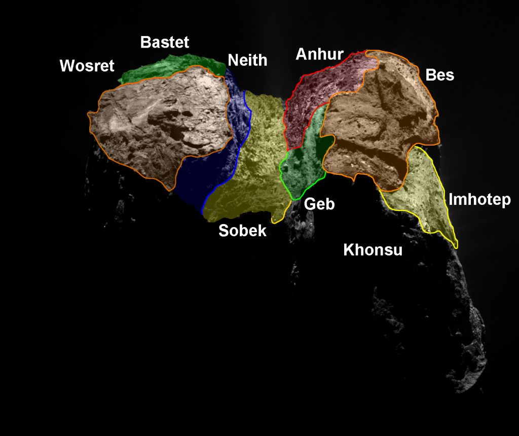
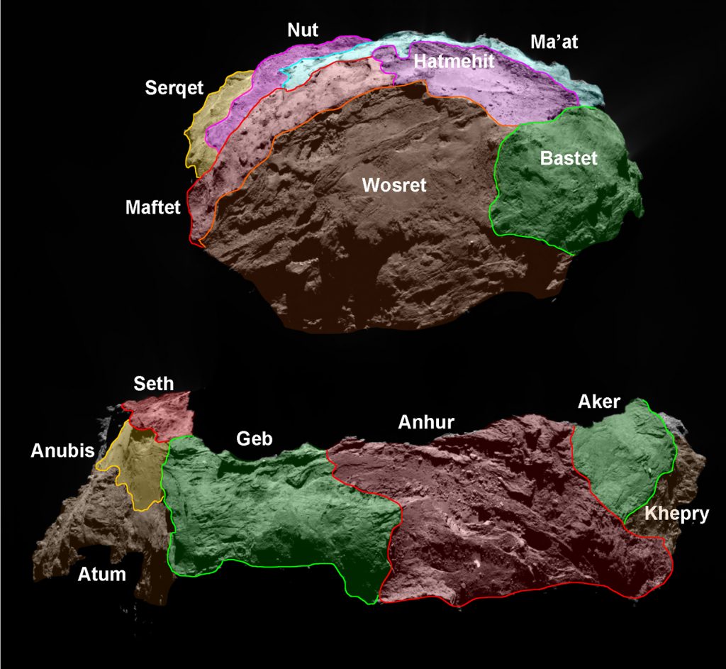
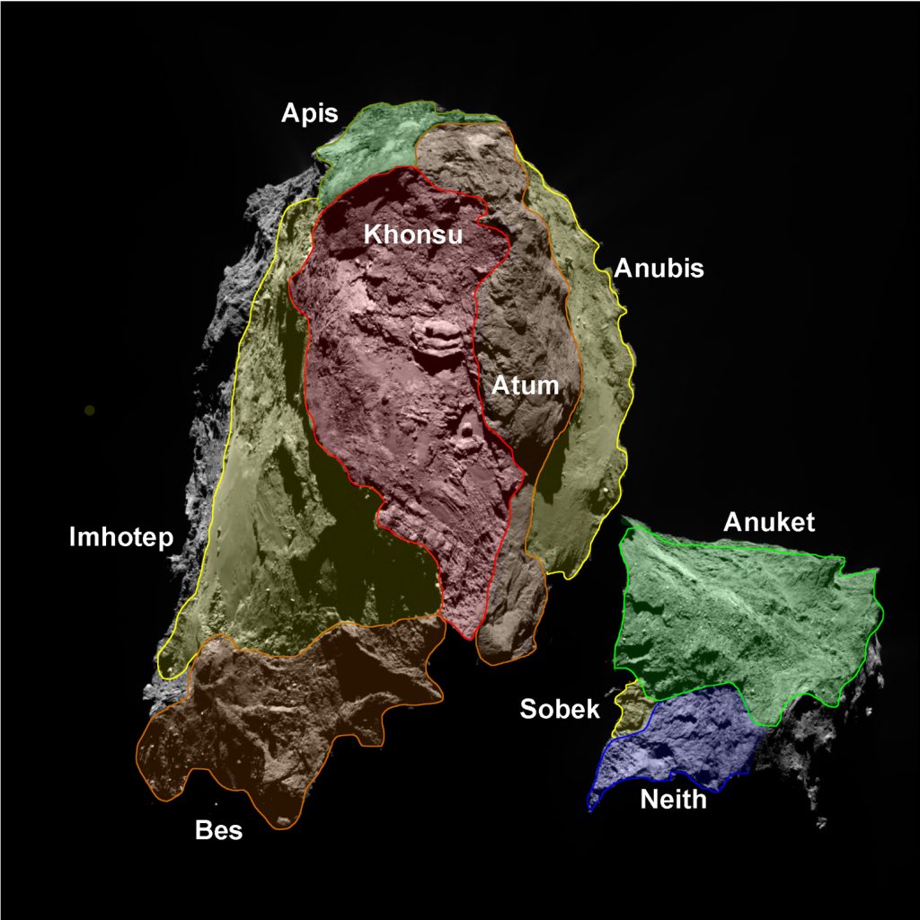
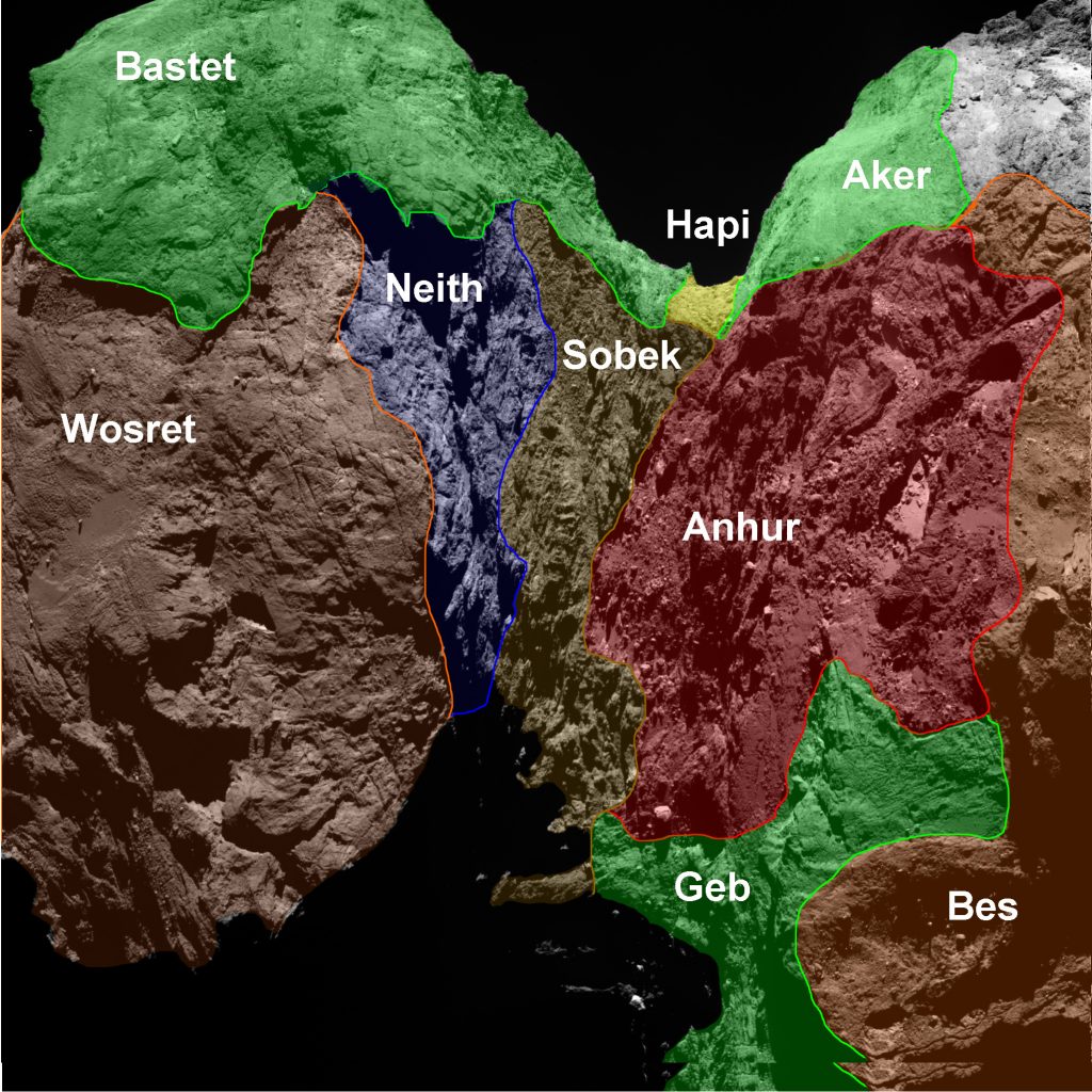
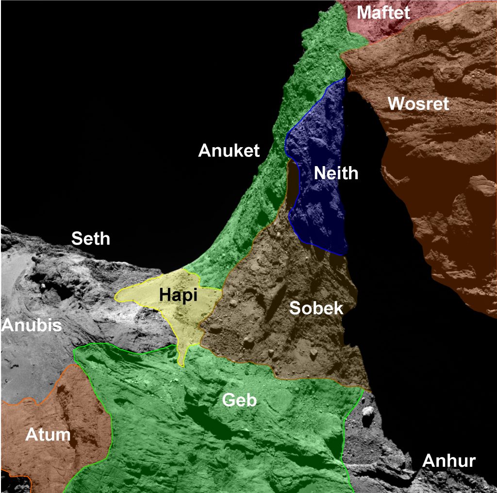
Below are a series of maps highlighting the various regions on the southern hemisphere of Comet 67P/C-G:
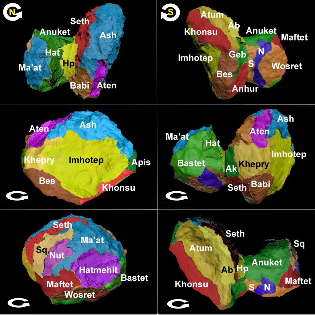
And finally a set of views of regions across the entire comet, both in the northern and southern hemisphere:
—
This blog is based on the presentation by Mohamed El-Maarry during today’s science briefing at the European Space Operations Centre (ESOC) in Darmstadt, Germany.
The images of the southern hemisphere and the comet maps are from the paper ‘Regional surface morphology of comet 67P/Churyumov-Gerasimenkofrom Rosetta/OSIRIS images: The southern hemisphere‘ by El Maarry et al, which was published earlier this year in Astronomy and Astrophysics.

Discussion: 15 comments
Hi Claudia
I’ve identified several rather important contradictions on the maps presented in this post asClaudia
I’ve identified several rather important contradictions on the maps presented in this post as well as several smaller contradictions. The more important contradictions are:
1) While Bes is clearly marked in the first map it disappears in the second one, taken over by Geb and Anhur. It’s not perspective, you can see the same features coloured differently.
2) In the montage, right hand column, middle image, “Seth” and “Babi” are actually “Anhur” and “Bes” respectively.
3) On the third map, Anuket is shown including the second heavily shadowed scarp along its border with Atum and even incorporates the third (non shadowed) scarp. These two scarps are incorporated into Sobek in the fifth map. In that map, the border kisses only the first scarp which is the scarp where Vincent et al’s jets 27 and 31 were located. This constitutes a 4-500 north-south drift in the Anuket border.
4) Staying with the same Anuket border in 3, above, its border with Neith is similarly southerly in the third map (it starts half way along the Maftet border along the head rim. But in the fifth map, the Neith border has crept north by several hundred metres almost to the beginning of Maftet where that dog-leg in the head rim is. In fact, the parallax of the head rim rebate diminishes the effect. It’s as good as in line with the dog leg.
There are several smaller contradictions:
1) In the top-right montage, the border of Seth with Babi has been truncated with respect to the older ESA regional map. On that map; Seth used to have a finger protruding 400 metres along the Hapi rim and into the Babi area. This isn’t a contradiction between these recent maps and so might have been an intentional change in the border line.
2) The Seth border is also shown as being too far down Ash in the bottom-left montage frame (difficult to judge with the acute perspective but nevertheless a few hundred metres off because of that acute angle.
3) In the bottom-left montage frame there’s a green blob on the Serqet rim. This is the smooth area between the pillars of the C. Alexander Gate. It was part of Serqet in the old regional map but this green blob implies that it’s thought to be a part of Anuket peeping round from under the head rim. That’s not possible from this angle- the green blob is definitely the smooth area between the pillars of the C. Alexander Gate. Although this is certainly a contradiction with the old ESA maps, it also appears to contradict the top-left and bottom-right montage frames too, although this area is very nearly over the horizon in both frames.
4) On the third map, a finger of green depicting Apis extending up into Ash but not there in the bottom-right montage map. This finger is not in any previous map either.
There are several other anomalies to do with Geb/Bes, Wosret/Maftet and (possibly) Seqet/Ma’at but they are too involved to explain here.
Hopefully, these contradictions could be corrected, especially the first four. They could lead to future papers inadvertently causing confusion by citing these areas that others interpret as different areas. This would be due to referring to a different map in this presentation (or referring to the old ESA regional map instead).
Apologies for repeated paragraph- a cut n paste, sent it above the top of screen 🙂
Hi A. Cooper,
This is Ramy, the paper’s first author. Thank you very much for your comments. I believe you are right with respect to the Sobek/Anuket border but please allow me a couple of days to take a closer look and respond fully in more detail.
Thank you,
Ramy
Hi Ramy
Thanks for replying. I second what Marco says in his reply to you below re outreach.
Hi Ramy
Marco suggested I do a blog post to clarify what I’m saying and on reflection some of my bullet points above are rather short on info and of course, without any annotated photos. So I’ve done a post with photos which deals with Bes/Geb/Anhur (point 1). I’ll add the others in due course:
https://scute1133site.wordpress.com/2016/10/04/part-65-osiris-map-anomalies-and-corrections/
Cheers, Andrew
The above-linked post has just been updated to include points 2 and 3 plus two others before I do point 4.
Hi Andrew,
Thank you for your patience. I have look carefully at your suggestions and I have decided to prepare an erratum to address some of these issues. I have actually just submitted it to the journal. I have also mentioned your name explicitly in the acknowledgments to show your contribution. Allow me to answer your concerns now point by point
1) While Bes is clearly marked in the first map it disappears in the second one, taken over by Geb and Anhur. It’s not perspective, you can see the same features coloured differently.
This was a small misalignment partiucalry Anhur/Bes and Anhur/Khepry but Geb is fine. In your detailed post, you compare two different scarps in Geb and assume they are the same one.
2) In the montage, right hand column, middle image, “Seth” and “Babi” are actually “Anhur” and “Bes” respectively.
Right, thanks for picking on that. I have corrected the labels.
3) On the third map, Anuket is shown including the second heavily shadowed scarp along its border with Atum and even incorporates the third (non shadowed) scarp. These two scarps are incorporated into Sobek in the fifth map. In that map, the border kisses only the first scarp which is the scarp where Vincent et al’s jets 27 and 31 were located. This constitutes a 4-500 north-south drift in the Anuket border.
Correct! The original border is intended to be the first scarp. As a result I have corrected this inconsistency.
4) Staying with the same Anuket border in 3, above, its border with Neith is similarly southerly in the third map (it starts half way along the Maftet border along the head rim. But in the fifth map, the Neith border has crept north by several hundred metres almost to the beginning of Maftet where that dog-leg in the head rim is. In fact, the parallax of the head rim rebate diminishes the effect. It’s as good as in line with the dog leg.
I believe there are no inconsistencies there but with the change in the map, it is possible that this has been taken care of since I also modified the Maftet boundary related to another one of your comments.
There are several smaller contradictions:
1) In the top-right montage, the border of Seth with Babi has been truncated with respect to the older ESA regional map. On that map; Seth used to have a finger protruding 400 metres along the Hapi rim and into the Babi area. This isn’t a contradiction between these recent maps and so might have been an intentional change in the border line.
2) The Seth border is also shown as being too far down Ash in the bottom-left montage frame (difficult to judge with the acute perspective but nevertheless a few hundred metres off because of that acute angle.
For these two points, there have been minor modifications to these borders because as the work progressed, we were able to define the regions on shape models rather than rely on 2D images like we did in the first paper, which resulted in a few minor modifications. The biggest changes were already listed in the paper as “addendum” to the northern hemisphere regions.
3) In the bottom-left montage frame there’s a green blob on the Serqet rim. This is the smooth area between the pillars of the C. Alexander Gate. It was part of Serqet in the old regional map but this green blob implies that it’s thought to be a part of Anuket peeping round from under the head rim. That’s not possible from this angle- the green blob is definitely the smooth area between the pillars of the C. Alexander Gate. Although this is certainly a contradiction with the old ESA maps, it also appears to contradict the top-left and bottom-right montage frames too, although this area is very nearly over the horizon in both frames.
This is just a small artifact in the 3D visualization tool. There cannot be any contradictions in these panels because they are merely different views from the 3D shape.
4) On the third map, a finger of green depicting Apis extending up into Ash but not there in the bottom-right montage map. This finger is not in any previous map either.
There are several other anomalies to do with Geb/Bes, Wosret/Maftet and (possibly) Seqet/Ma’at but they are too involved to explain here.
Read my comments above. Geb/Bes has no anomalies and I have modified the Maftet/Wosret boundary and it matches your suggestions
Cheers,
Ramy
Hi Ramy
Thank you for getting back to me and Marco. And thanks very much for adding us to the acknowledgements in the paper. I’m sure Marco will be delighted he’s “spot on” regarding the cliff collapse on the first scarp at the Anuket/Sobek border.
I’m pleased you agree with most of my observations and explain others as being intentional changes or small reader artefacts. This leaves my number 1 with which you disagree but I would still stand by. I won’t pursue that any further though.
And there’s also the issue of the Neith border (my point 4), which is tricky. I wholly agree that the supposed Neith anomaly I pointed out was really a Maftet anomaly. When the Maftet border is moved to its correct position, it then lines up with the same end-point for the Neith line as in the other map view. However, Neith also bulges out further in one view than the other, that is, it bulges out further down the neck and into Anuket in one of the maps. That happens even though the endpoint of its border touches the same point on Maftet as in the other map. And in the other map the bulge is less obvious and set back southwards by 100m or so.
The Neith bulge was dealt with in a second update to my blog post which I didn’t notify you of in these comments because I didn’t want to do a running commentary of updates. It’s under the ‘POINT 4’ heading.
I also did a third update, embedded in POINT 3, which was adding some context to Marco’s Sobek/Anuket shunt. The accompanying map annotations in that update show the three anomalies together: the Sobek/Anuket anomaly, the (claimed) Neith/Anuket bulge anomaly and the Maftet anomaly all together in one photo. I think it’s quite accurate and the dotted lines show a finger of Sobek nestling in under the supposed Neith bulge that I’m suggesting has been extended north.
I won’t badger you with further comments on any of the points raised in my analysis/blog post above, but I’m very happy to discuss the Neith bulge if you wish. Also, if I find any new anomalies, or what I believe to be anomalies, I’ll leave a comment here. I don’t think I can see any more than what’s in my post though.
Cheers
Andrew
Hi Emily,
These maps show a conflicting border position between Anuket and Sobek. This one is quite crucial in determining pre-post perihelion changes and relating them to outbursts because many of them straddle these regions.
The following blog post outlines this obvious discrepancy:
https://marcoparigi.blogspot.com.au/2016/10/anuket-sobek-border-confusion.html
The change itself is visible and obvious from long distances, so many images, both NAVCAM and Osiris are available to cross check these regional borders.
Hi Marco,
Thank you very much for your comments. At a first glance, you may be correct but please give me a few days to check this issue more fully and respond with more details.
Thanks again
Hi Ramy,
Thank you for your response and consideration. It isn’t always easy to get attention as I am “non-published” in a peer reviewed sense (yet), but I am certainly very familiar with the morphology of Anuket down to the small scale and with trans-perihelion changes..
Thanks again to Claudia (and Emily) for communicating science to the public in the direction of outreach, but also qualifying queries and non-peer review back to the scientists as “in-reach”
Hi Marco,
Thank you for your patience. I have looked carefully at your suggestion and I have decided to prepare an erratum to address some of these issues. I have actually just submitted it to the journal. I have also mentioned your name explicitly in the acknowledgments to show your contribution.
You are entirely correct about the Sobek/Anuket boundary. The correct one is at the first scarp, not the second and it is indeed an important area because it contains a few source regions of large outbursts. You are also spot-on with your conclusion about changes in the scarp. It is not very clear in the images but i believe there has been indeed a cliff collapse there. So thank you very much for your deilgent efforts!
One final friendly advice, I feel you are too harsh in your blog when you assume that the “mapping team has one job only, but it’s an important one!”. Given the vast amount of work and data being planned, received, and analysed every single day for 2 years, there were certainly many more tasks that each individual in the team had to attend to. We did not have the luxury of “just doing the maps”. We try to double-check everything before its final release but sometimes mistakes happen. This is not an excuse of course. However, I am happy that there are a lot of enthusiastic followers like you of the mission results who are quick to point out any inconsistencies with the released products so that we can make any corrections if necessary.
Hopefully, ESA will issue another blog with the corrections. otherwise, they should come out soon as an erratum to the paper.
Thanks again,
Ramy
In the interests of narrowing down the cause of the scarp/cliff collapse, I have narrowed down its timing.
I am a bit surprised, but the results are as follows:
https://marcoparigi.blogspot.com.au/2016/10/timing-for-anuket-sah-collapse-not.html
Hi Ramy,
Thank you for your replies. I look forward to the addenda and errata. I think from what you say that the famous outburst described in this other post:
https://blogs.esa.int/rosetta/2015/08/11/comets-firework-display-ahead-of-perihelion/
Is not in Anuket as the paper says, but is actually in Sobek?
I guess that when the paper was written, the Southern areas’ borders were not defined well, and hopefully, the newer paper with a summary of all the different outbursts has them more accurately placed from now corrected and verified maps.
My “one job” jibe was tongue in cheek and not intended personally. I will change it to a more polite critique.
It does, however reflect my frustration at the overall mapping, naming and measurement process and progress.
I find it hard to believe that tens of thousands of dust particles collected by Rosetta’s instruments could be individually named as they were collected, but when I am pointing out a cliff collapse/change, I have to describe and mark it’s location every time or invent a numbering convention to identify it from similar nearby cliffs. Every rock and crevice should get a name, with bigger objects getting priority, of course.
I took to starting to name some rocks myself – Tekhenu in Anuket, near where I have found several other changes. Several boulders have moved there but I can’t tell you their names, because they haven’t been named yet.
As far as measurements goes, I am befuddled as to why before and after perihelion measurements are not accurate to less than one metre. I would have thought it simple trigonometry and triangulation techniques for various well characterised features. The only dimensions listed of the comet are plus or minus 100m or so.
Collaboration in 67P science can only seriously accelerate when it becomes easy to identify areas and small features such that they instantly know and can search for what else has been studied of that same feature. At this stage, a search for “Anuket outburst” would find one actually in Sobek.
@Marco (and Ramy/Claudia) regarding naming.
You said:
“Collaboration in 67P science can only seriously accelerate when it becomes easy to identify areas and small features such that they instantly know and can search for what else has been studied of that same feature.”
A very good point. Indeed, even if we named the larger features this would help a lot. At the moment I have to be very careful about directing readers to specific large features before directing them on to nearby medium-sized features and from there to the small details I want to discuss.
This takes an inordinate amount of prose. I need to characterise features that look very similar to nearby, irrelevant features. They can only be differentiated if they’re described in great detail as we progress. The process is involved and arduous for writer and reader alike- to the point where Dr. Massironi said my descriptions were too long and needed to be shorter. But if they were shorter I’d be curtailing them at the level of medium sized features. That would for correspond to say, single, 20-metre boulders, 50-metre cracks, 100-metre-square ‘flows’. But I’m going right down to the polygonal arrangements of half a dozen 5-metre boulders, arrays of 10-metre cracks that appear to change shape under different lighting, and accounting for undulations in the topography to catch 30m x 30m areas that change shape with perspective due to those undulations.
If I could launch in by saying something like, “the talus sits at the bulbous end of Hatshepsut” or even, “the end of the crack in question is in line with the tips of Hatshepsut and Thutmose and disappears into the shadow of the Fourth Cataract”, my job would be a lot easier.