A recent OSIRIS image is featured as our ESA Space Science Image of the Week; the caption is mirrored below:
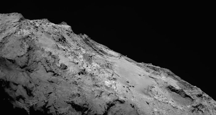
This beautiful landscape feels within arm’s reach in this stunning view across the Imhotep region on Comet 67P/Churyumov–Gerasimenko.
The view was captured by Rosetta’s OSIRIS narrow-angle camera on 17 January 2016, from a distance of 86.8 km. Measuring 3.2 km across, it captures one of the most geologically diverse areas of the comet.
Imhotep is perhaps most easily identified by the broad smooth area that occupies the centre-right portion of this view. This smooth dusty terrain, which covers about 0.8 sq km, is etched with curvilinear features stretching hundreds of metres and which have been found to change in appearance over time.
Many large boulders are also seen scattered within the smooth terrain, including the boulder Cheops in the foreground. Smaller but more numerous boulders are associated with exposed cliff faces and are most likely the product of erosion. In some debris falls, detailed analysis has revealed the presence of water ice.
Particularly eye-catching is the distinctive layered and fractured material to the left of centre in the background. Similar patterns are also seen in the exposed cliff-like faces towards the right of the scene too, where Imhotep transitions into the Khepry region.
Layers like this are seen in various locations on the comet and scientists are trying to understand how they might be related to the comet’s formation and/or evolution.
Just in front of the prominent left-hand stack of layers a number of small round features can be found. They have a well-defined rim with a smooth interior and appear slightly raised from the surrounding material. One explanation for their appearance is that they are ancient sites of active regions covered by dust and are now being revealed by varying erosion of the overlying layers.
Further in the foreground again and a relatively smooth ‘pathway’ appears to lead towards a more consolidated summit. To the left of this path is the Ash region, while the sheer apex at the top left of the view marks the boundary with Apis.
Use the comet viewer tool to aid navigation around the comet’s regions.
This image was first published on the OSIRIS image of the day website on 21 January 2016.
Check out more new OSIRIS images via the image of the day archive.




Discussion: 15 comments
Dear Rosettas,
What I would like to see are ‘before’ (closest) and ‘after’ pictures. If possible, more-or-less from a similar point of view.
Met vriendelijke groeten, Henk Smid
Hi Henk,
In case you missed it, this blog post shows some of the changes spotted in Imhotep already before perihelion: https://blogs.esa.int/rosetta/2015/09/18/comet-surface-changes-before-rosettas-eyes/
Keep an eye on the OSIRIS image of the day website for more recent images of the same area! https://planetgate.mps.mpg.de/Image_of_the_Day/public/IofD_archive.html
Best wishes
Emily
Emily: Might also want to compare the region we have the closest view so far, when Rosetta saw its own shadow:
https://blogs.esa.int/rosetta/2015/03/03/comet-flyby-osiris-catches-glimpse-of-rosettas-shadow/
Although this is from a different angle.
Hi Emily and OSIRIS Team. Enlisting my fantastic list of thermo-sinking processes:
-Eroded sand and gravel sinking.
-Daily inspiration.
-Rupture and massive sinking of subsurface “moving sands” ponds. Unknown fluids acting as lubricants. Plausible agents of surface out-bursts.
-Traces of electro-resistivity. Inducted by the impact bow field interacting with core’s spin. Plausible agent of the apparent scarcity of amorphous ices.
-Other unknown processes apply.
This is fiction.
Here is my fantastic list of ‘smooth’ surfaces:
– The mirror sanded, waxed marble, floored aspect surfaces, left behind by the ‘flowing prairies’, also seen as the trails of lakritz residual kinetics.
-The ‘low lands’, now believed unable to slowly accumulate at surface. And quite probably the ‘smoking leaks’ of former out-bursts.
-The deposited blanket of coma return. Quite probably ‘Super Puff’, aka dandelion dust is last aphelion dust.
-Other smooth surfaces unseen should apply.
This is fiction..
At this micro gravity flowing should be very easy. Contact points in between particles could be microscopic. Additional lubricant could be liberated from the structured material, at the contact points, during avalanche events..
Hi Logan, Hi Emily,
Have been ill for a few months so starting to catch up again. The dusty areas do seem to be a type of fluidised bed. The lubricant is likely small amounts of sublimating gases seeping from below through the dust. The microgravity is key here as capillary action draws the gases to the surface of the dust particles acting like a cushion around each particle. Water molecules being highly polar are prime candidates for this.
This fluid nature of the dust helps to explain the dunes and ripples we have seen. It collects in ponds and “seas” with remarkably level surfaces, more like a liquid. Avalanches probably expose fresh layers of volatiles to add more lubrication as you suggest. The volumes of the sublimated gas need only be tiny as they will tend to cling to the dust particles.
Each particle is a mini comet as we saw from the dust analysis from the tail. As each particle is slowly eroded by friction within the slowly moving dust/fluid, small amounts of volatiles escape from each particle too. Just my best guess, but it seems you are thinking along similar lines.
The change in the surface features of Imhotep is quite marked especially the now quite large depression near Cheops. This was only faintly visible before Perihelion and the “shelf” that Cheops appeared to be balanced on the edge of, is gone, filled in by migrating dust I guess. These depressions on the plain suggest subsurface sublimation has created elongated sinkholes similar to those seen towards the top of the image that look like ponds in little calderas. Perhaps sites of “jets” in the past as Emily suggests.
This image shows the layering of the comets bulk material both horizontally, indicating some sedimentation process, and vertically which is likely some tidal/thermal stress process. The fallout from the decaying coma as the comet moves around its orbit could account for the sedimentation. The thickness of these layers may be a way of tracing 67P’s past orbital history.
There also lots of little black potholes in the cryorock surfaces, where trapped pockets of volatiles have erupted from the surface in little cryovolcanos. Where these eruptions are on a slope the characteristic horseshoe shape forms as the erupting gases erode the lower side of the caldera rim. The larger the eruption, the larger the crater left behind. Those on level surfaces fill with dust over time to create the little raised ponds. When we first saw these I was struck how similar they were to mud volcanos on Earth.
These are the words describing the flashes in my head. Also praying for Robin’s health 🙂
Robin: Good to see you back.
Best wishes, Kamal
ERRATA, Should say: ‘At the impacting points, …’
Hi Gerald:
‘The theory of newborn stars arising in clusters as they “adopt” interstellar gases actually dates back to a 1952 paper. More than a half-century later, this once speculative idea suddenly has key evidence to support it.’
This study on a trio of multi-aged Star clusters could carry implications to determination of age in Cometary objects.
Via: https://phys.org/news/2016-01-stellar-parenting-stars-stray-cosmic.html
Formation of new stellar populations from gas accreted by massive young star clusters,
https://nature.com/articles/doi:10.1038/nature16493
Great to see some (unexpected) progress there! Thanks for the links, Logan.
Was explained around here, some months ago, the concept of the Solar Wind not being shocked by the interstellar medium [A Pioneer discovery].
On trying to grab the idea, I put over the bar the visual allegory of a jellyfish, for the kinetic interface.
Would like to insist in it. As the Pioneer Teams’ proposed ‘foamy’ surface could well act as a nano-dust ‘trap’. And every single ‘bubble cell’ of that foam Acting as a micro formative environment, for cometary material.
This is fiction.
Some kind of dust trapping should also be happening at 67P’s impact front, when no longer shocked, after perihelion.
But that is a long shot. I’m totally ignoring scaling limits.
[That highly speculative trap could be contributing to the ComaReturn blanket mechanism].