


Approximately 30 km on the ice from the nearest town, Ikaluktutiak in the Canadian Arctic, it is mostly white.
A thin layer of snow sitting on top of 2 m of ice might sound boring to some people but not to the members of the AKROSS field campaign. The goal is to better understand the interaction of snow and ice with the electromagnetic waves of CryoSat, and therefore improve estimates of sea ice thickness.
Acquiring snow and ice measurements in the field can be complex in harsh environments like polar regions, but is extremely important and relevant for climate studies. Sea ice reduction is a major positive feedback on Arctic surface temperature rise.
The tricky business of snow on ice
The CryoSat mission has been monitoring polar regions for a decade now. It contains a SIRAL (SAR/Interferometric Radar Altimeter) instrument that can measure the elevation of ice. In order to be able to extract properties like ice thickness, snow and ice properties measured in the field, with matching CryoSat acquisition from above, are needed.
One of the variables affecting the retrieval of sea ice properties is the small layer of snow that covers the ice. The snowpack is really the first thing that the radar signal interacts with, therefore detailed information on snow and ice microstructure is needed.
Quantifying snow properties, especially the microstructure and surface roughness in the field, for a microwave radiative transfer model (SMRT in our case), was one of the main objectives of the AKROSS campaign.
Our group, composed of Richard Essery (University of Edinburgh), Melody Sandells, Nick Rutter (Northumbria University) and Julien Meloche (Sherbrooke/Northumbria University), focused on the snow measurements. Randy Scharien (University of Victoria) and John Yackel (University of Calgary) focused on sea ice measurements.
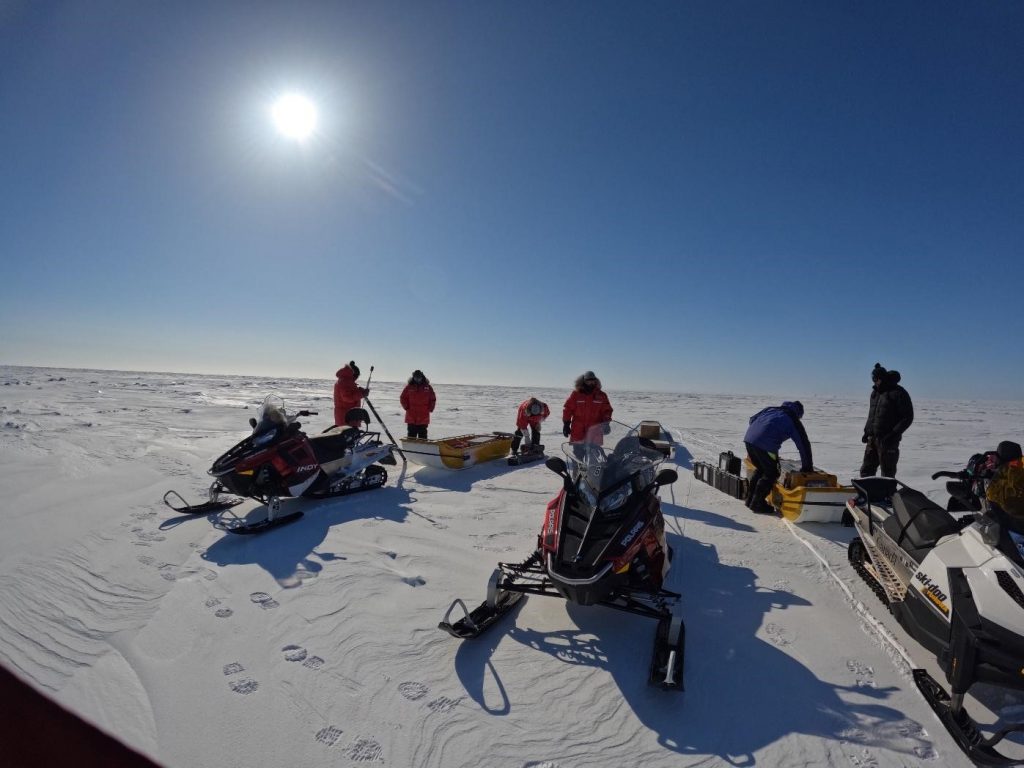
The team prepares for a 30 km trek across the ice on snowmobiles. (Credits: J. Meloche)
Armed with our trusty snowmobiles, we set off every day to the ice with our goal of completing data collection across a transect that matches CryoSat acquisition. The data mainly consist of snow parameters needed for microwave radiative transfer modelling, or in other words, modelling what a microwave sensor like a radar altimeter would measure in terms of radiation (waveform).
We measured the snow depth (a lot!) for statistical estimates around a fixed area. This dedicated area is then used for fancy snow microstructure measurements. First with a laser (reflectance of snow grains) and then with a snow penetrometer, which measured the force needed to break snow crystals.
The last method is ‘la crème de la crème’ of microstructure measurements. This method, often referred to as micro-tomography (or micro-CT), is a 3D scan of snow or ice samples at the micro-scale. The instrument uses X-rays to acquire 3D images with micrometre resolution.
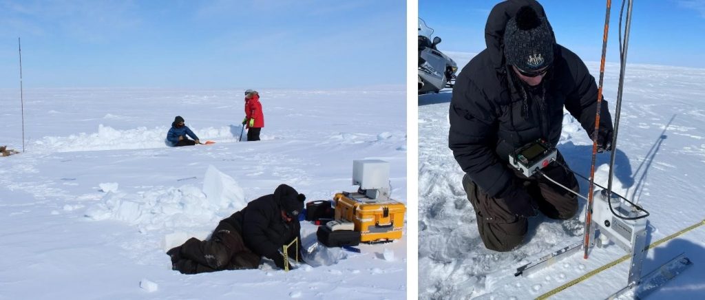
Digging deep into the snow to let the fancy measurements begin. (Credits: J. Meloche)
A 3D representation of snow crystals and aggregates can be used to mathematically quantify their representation in space (or more specifically, an autocorrelation function of the ice/air matrix). First, samples need to be extracted without breaking the snowpack internal structure. Then they are transported back to the research station for casting. In a cold room, a solution of contrast-enhanced diethyl phthalate (DEP) is carefully added one droplet at a time. This solution freezes, keeping the structure intact for transportation.
What kind of transport? Well… the snow samples were shipped from Ikaluktutiak, Nunavut to Davos in Switzerland, where the scanner is operated by researchers from the WSL Institute for Snow and Avalanche Research SLF. That’s a long way for snow samples that need to be kept frozen.
The blue boxes containing the samples were transported as luggage to Edmonton and then shipped in special containers filled with dry ice to Davos. Those boxes indeed contained only snow, but also our hopes of obtaining extremely rare 3D representations of snow on sea ice. Once analysed, all data will be made available with hopefully a supporting paper highlighting simulation of the SMRT model for Ku-band Altimetric data (CryoSat).
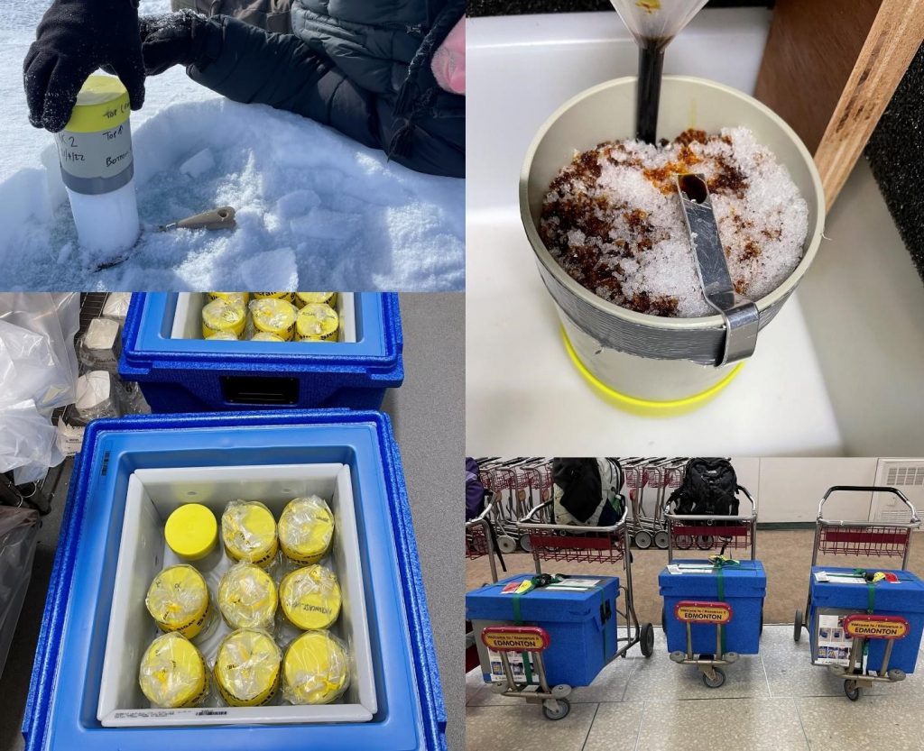
Preparing snow samples for transport to the lab in Switzerland. Got to keep them cold! (Credits: J. Meloche)
In total, the field campaign lasted a week. We spent four days of work on the ice and the remaining time in a cold room for casting (because working at room temperature is overrated…).
After 200 km of snowmobiling at -30°C, polar bear mirages, and a lot of ‘proper’ English tea, our team of snow nerds returned safely with hard drives filled with data and good memories.
Post from: Julien Meloche, Université de Sherbrooke & Northumbria University
Discussion: no comments