


From Henriette and Sine (DTU) and Tommaso (ESA), Svalbard, 30 April

Spectacular scenery heading north
After a day of being grounded owing to bad weather, the morning briefing of the 27th restored our confidence that our mission to collect sea-ice thickness measurements, north of the Svalbard islands, would be successful. This was our second option, the first one, which meant flying over the Austfonna glacier, had to be postponed by one day owing to prohibitive wind conditions.
Nevertheless, this additional day was going to be used by the ground team of scientists from University of Oslo and Norwegian Polar Institute to mount a number of corner reflectors that are used as control points for the airborne measurements.

Sea ice
We arrived at the airport around mid-afternoon and, after having checked that all the instruments were working as expected, we took off.
The measurements today consisted of sea-ice elevation mapping using the ASIRAS radar and laser scanner altimetry. In addition, we gathered our position and attitude information with GPS and inertial navigation systems. Also, a downward looking camera is used for visual inspection of the ice conditions.
After leaving the airfield, we headed north, flying above the Wijde Fiord which was partly covered by fast sea-ice. On the right, a number of outlet glaciers attracted our attention. The shadows inside the crevasses and the reflection of the Sun over the white and blue ice were spectacular.
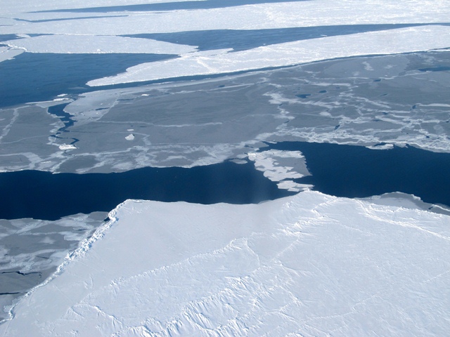
As soon as we left the northern coast, the sea-ice disappeared. This was expected since the latest news on wind direction, suggested that the ice had moved towards the northwest. In fact, the ice was there, waiting for us eight nautical miles north.
We noted areas where the sea ice was rather compact and other zones, where large sections of floating ice were interleaved by narrow winding water leads that resembled land rivers.
We navigated over one planned CryoSat track for almost 200 miles in the ascending direction up to 82.5° N. After one-hour, we flew over the same track but in the opposite direction. We ‘rendezvoused’ with the satellite half-way through and we were happy to be informed that both space and ground systems had acquired that segment successfully.
Sea ice
Before landing at the airport, Henriette and Sine suggested performing two passes over the runway at an altitude of about 1000 feet to cross-calibrated the laser and ASIRAS. The pilots and airport traffic control consented.
We safely landed just in time before it started to snow.
It was another successful campaign day and this could only be achieved thanks to the skills of colleagues and pilots who plan and execute these activities in totally safe conditions.
But this time, we did not see any polar bears!
Discussion: no comments