From Dirk (ESA), Greece, 3 September
On Friday, we spent a lot of time working out the best flight path for Saturday’s flight. The weather forecast indicated that it would be cloudy towards the northern leg of the path we had hoped to take – so we decided to stick to the south of Turkey where it promised to be clearer.
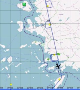
The idea was to fly in ‘boxes’ or ‘squares’ around different points the GOSAT satellite would be sensing. The aim was to give us a better understanding of the variability in the aerosols layers. The satellite gives us pixels of 10×10 km so we wanted so see how the aerosols actually differ in this range.
While we were planning all this, the plane took off from Chania airport to sample aerosols along the flight path of the NASA/CNES Cloud-Aerosol Lidar and Infrared Pathfinder Satellite Observations, or CALISPO, satellite.
So, on Saturday, according to our revised plan, we set off up along the Turkish coast and flew in boxes around certain GOSAT target points, avoiding the cloudy areas further north.
The map above shows our route and target points.
In the southern-most box we saw a big forest fire and hopefully caught some aerosols generated from the fire.
The plot above shows the different aerosol layers and a single cloud in yellow at the time the satellite was above.
All in all, it was another successful flight even though cloud prevented us sampling all the target points we had originally hoped to catch.
We also had a little celebration on Saturday as it was the BAe 146-301 aircraft’s 30th birthday!


Discussion: no comments