This week’s CometWatch entry soaks up the sights of a number of regions on both the small (right) and large (left) lobes of Comet 67P/Churyumov-Gerasimenko.
The image was taken by Rosetta’s NAVCAM on 17 June from a distance of 30.8 km, and the image measures about 2.7 km across.
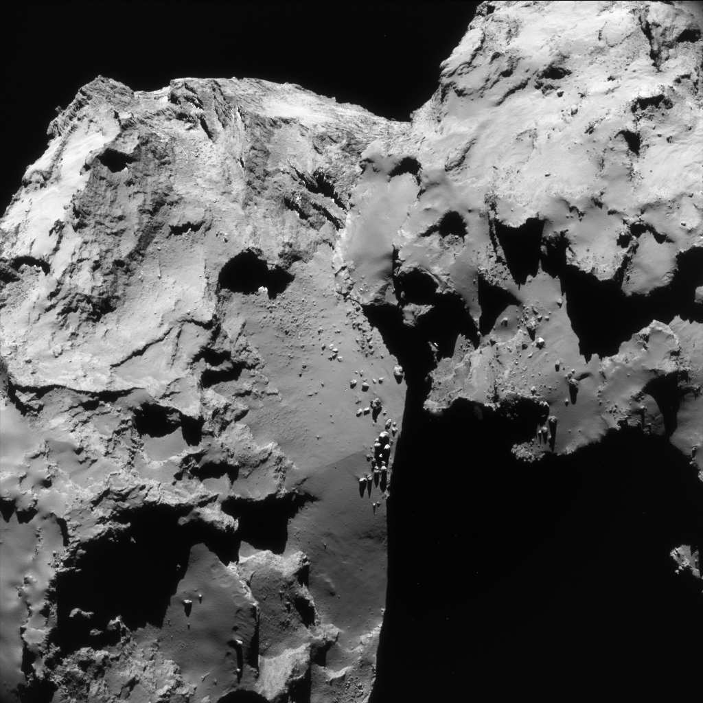
Enhanced single frame NAVCAM view on Comet 67P/C-G taken on 17 June 2016 from a distance of 30.8 km. The image scale is 2.6 m/pixel and the image measures 2.7 km across. Credits: ESA/Rosetta/NavCam – CC BY-SA IGO 3.0
It gives a birds-eye-view onto the layered terraces in Seth (bottom left) and Babi (top left), with hints of the smooth dust-covered Ash region towards the bottom left corner.
The boulder-strewn neck region, Hapi, lies in the centre of the image. Following the course of the neck ‘up’ towards the top of the frame, the boundary between Hapi and Aker is encountered.
The view of the small lobe, to the right of the scene, is dominated by the dusty surfaces of Ma’at, and casts an impressive shadow over the landscape below.
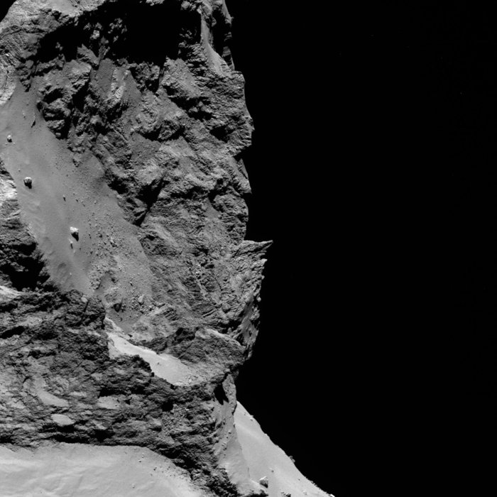
OSIRIS narrow-angle camera image taken on 8 June 2016, when Rosetta was 29.7 km from the centre of Comet 67P/Churyumov–Gerasimenko. The scale is 0.53 m/pixel and the image measures about 1.1 km across. Credits: ESA/Rosetta/MPS for OSIRIS Team MPS/UPD/LAM/IAA/SSO/INTA/UPM/DASP/IDA
An OSIRIS ‘image of the day’ released this week (above) provides a complementary view of the biggest terrace in Seth, which – following the Egyptian naming convention on the comet – scientists have nicknamed Aswan.
Aswan boasts a variety of geomorphological features, such as steep, layered and fractured walls that contrast against the relatively smooth and flat, dust-covered terrace that was once considered a possible landing site for Philae.
Along the cliff edge multiple arch-shaped features can be seen; they likely represent an eroding margin linked to sublimation and fracturing.
A handful of large boulders are also present amongst many smaller ones; to give a sense of scale, the majority of boulders seen in this image are around 2 m wide or larger, with the large boulder situated close to the cliff measuring just over 19 m across.
A detailed morphological analysis of the Aswan region is presented in a new paper by M. Pajola et al: “The Aswan site on comet 67P: morphology, boulder evolution and spectrophotometry”, which is accepted for publication in Astronomy & Astrophysics.
The original NAVCAM image from today’s release is provided below:


Discussion: 5 comments
Hi Emily,
Finally more names for more places on 67P! It is time at least all the larger sinkholes and boulders get named too – Especially now that we know that in general, they are still there, unchanged and easily identifiable even after the rigours of perihelion!
The line of boulders in Hapi matches to the perimeter of Seth and Babi. It strongly implies that the entire perimeter was once seated along the boulder line and rifted away. The boulders are the crumbled-away detritus. Slide tracks are evident too. I’ve done a post on it:
https://scute1133site.wordpress.com/2016/06/25/67pchuryumov-gerasimenko-a-single-body-thats-been-stretched-part-47/
This isn’t a sudden find in this Cometwatch photo. It’s observable in many earlier photos. The principle of the slide is complemented in Parts 37 to 40 on the stretch blog. It’s a natural progression from the findings in those posts.
Hi Emily
The second photo, the OSIRIS photo of Seth, is rather deceptive. It contains a large chunk of head lobe in the foreground. It looks just like part of the body but it’s actually 1 kilometre nearer to us than the the smooth area of Seth beyond. It looks so much like part of Seth that it appears to be a continuation of the Aswan ‘crater’ rim beyond where it tapers away. OSIRIS don’t always include a context image and there isn’t one in this case. I’ve therefore annotated the picture. Here’s a link to just the picture itself. It’s the original, which isn’t rotated 90° like this Cometwatch version:
https://scute1133site.files.wordpress.com/2015/12/img_8855.jpg
It’s not a blog post, just a picture, but if you’d like to see the annotated version alongside the unannotated version in order to toggle between them, they are in the ‘photos for off-site comments’ in the stretch blog menu.
The annotated version shows a large section of Serqet in the foreground as well as Ma’at peeping into view beyond Serqet. Ma’at is the flat, white expanse that’s in fact stepped down by 100 metres or so behind that blocky ridge. That’s the ridge that disappears out of view to the right in the original and to the bottom in this Cometwatch version. Ma’at is stepped down by about as much as the smooth, white part of Serqet on this side of the ridge.
Hmm…small correction. It was I who swivelled it 90° from the original, which Emily has reproduced as it was. So, apologies Emily. I had swivelled it for a tweet, days before, knowing that it’s easier to recognise as Seth that way. I’d forgotten I’d done that. It does look more spectacular in the original (as represented above in this post) though.
Congradulations,wonderful!Dr.Amalia Kokkinou.