Do you enjoy poring over images of Comet 67P/Churyumov-Gerasimenko? Have you spotted any changes in its surface features since Rosetta first arrived at the comet in August 2014? We are keen to hear from you!
Between NAVCAM and OSIRIS, and not forgetting the regular “OSIRIS image of the day” images and our NAVCAM CometWatch entries, there are over 20 000 images publicly available to browse covering the 667 days Rosetta has to date spent at the comet.
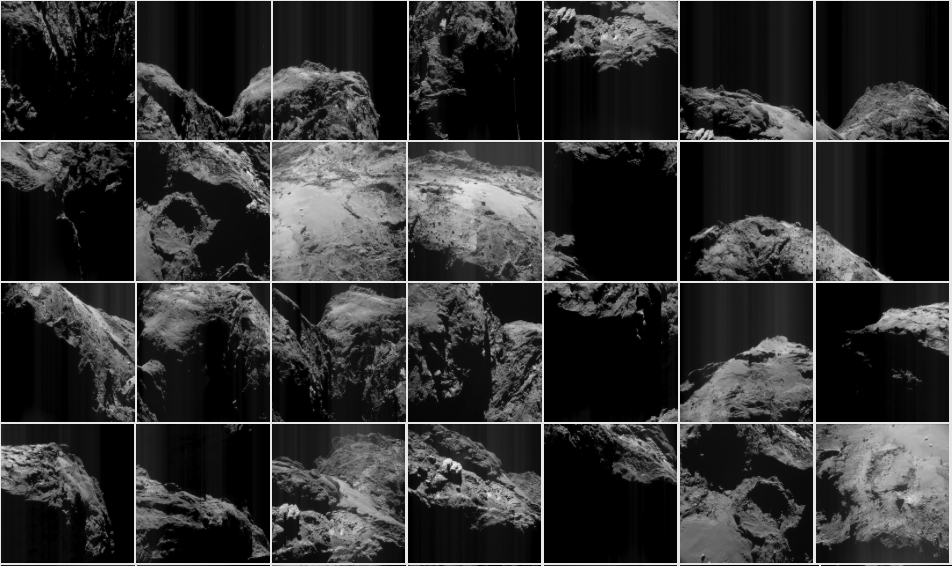
Indeed, 780 new images have been added to our NAVCAM Archive Image Browser this week, covering the period 6 April – 3 May 2016. Thanks to the hard work of the Rosetta downlink and archive group, this means that from now on, every month you will be able to access the full set of NAVCAM images taken during the previous month, and be able to keep even more up to date with the comet’s appearance than ever before.
Furthermore, with plentiful images available both before and after perihelion (Rosetta’s closest approach to the Sun along its orbit, when the comet’s activity was at its peak), including those captured from as close as 5-10 km from the comet’s surface at various times during the course of the mission, it is becoming easier to spot changes in surface patterns – as some of you have already pointed out in the comments section of this blog.
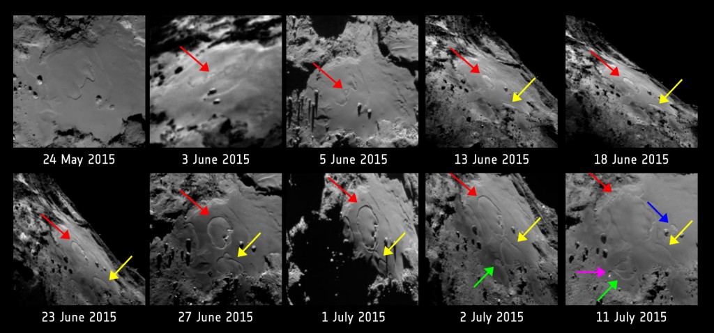
Changes reported by Rosetta scientists in the Imhotep region between May and July last year. Credits: ESA/Rosetta/MPS for OSIRIS Team MPS/UPD/LAM/IAA/SSO/INTA/UPM/DASP/IDA
We’d therefore like to make this a dedicated blog thread to invite you to submit your observations on possible changes that you may have noticed.
Feel free to post the before and after images as links to the archived images and a short description of what changes you can see, or links to your own or other blogs or image galleries where you may have already presented and discussed these images. In any case, please be sure to include the dates of the before and after images so we can follow up.
Do remember to be cautious when comparing images of the same region that have been taken under varying illumination conditions, or from different distances and therefore have a different scale – this can sometimes lead to mistaken identification.
In the coming months, as we approach the end of the mission, we hope to use your contributions to feature in future blog posts.
Happy hunting!



Discussion: 21 comments
Hi Emily,
I once again offer the odd differences in distance between boulders around the Anuket main crack.
https://marcoparigi.blogspot.com.au/2016/06/anuket-near-crack-changes.html
A distinctive equilateral triangle of boulders has become a larger equilateral triangle with the same boulders at its apexes, while the distance between the crack and the triangle appears to have shortened.
Hi Emily,
My one pet hate about this process is that none of the features have names. My current offering is just a name for a pet rock on 67P
https://marcoparigi.blogspot.com.au/2016/06/introducing.html
This is a duplicate comment, but I thought it best to place this link here so that one may go through them methodically.
I have studied many images, both pre and post perihelion in and around Abydos. There is one definite change I have found:
https://marcoparigi.blogspot.com.au/2016/08/67p-comet-changes-near-abydos.html
in which two large boulders visible in all suitable pre-perihelion images, have disappeared in all suitable post-perihelion images. The reason, A Cooper and I have found, is that a part of the cliff face has collapsed into Hatmehit and in the process the two nearby boulders have followed.
Of course it would be nice to find the corresponding rubble pile in Hatmehit, but these images have tantalising hints of glints from Philae as well. Not quite enough to prove location, but I am quite satisfied that the surrounding terrain matches the images from Philae’s cameras.
My next offering is moving south from the equator on Anuket but keeping to the thin part of the neck.
https://marcoparigi.blogspot.com.au/2016/06/more-anuket-changes-moving-south-from.html
In pre-perihelion pics there is a line of three rocks easily visible from many angles up to thirty Km away viewed from NavCam images. In post perihelion pictures the rocks have moved substantially – enough for the third rock to avoid easy identification, and many post perihelion images have been studied to verify this.
It is much easier to find changes with the right paradigm of what is happening. My search specifically targets the neck area for signs of lateral surface movements rather than hypothesised erosive features that are not eroding despite high activity. The paradigm I am following is briefly described in the following link:
https://marcoparigi.blogspot.com.au/2015/11/the-case-for-continuing-stretch-of-67p.html
A brief interlude in my posts about change for Rosetta’s Lament
https://marcoparigi.blogspot.com.au/2016/06/rosetta-lament.html
Time is ticking – September looms close 🙁
Hi Emily,
With a little bit of help from A. Cooper, have identified the movement in Anuket.
https://marcoparigi.blogspot.com.au/2016/06/lateral-movement-of-surface-in-anuket.html
Again, I have a suggestion of name for the sub-region explained in the post. Surface lateral movement as indicated in the link is evident from checking many pre and post perihelion images from different angles…
Hi Emily, a discovery of a “rockfall” from studying pre and post perihelion images. https://marcoparigi.blogspot.com.au/2016/06/rockfall-in-anuket-sah-region.html
Hi Emily,
Another short post on the rockfall area
https://marcoparigi.blogspot.com.au/2016/06/more-on-rockfall-area.html
With a little help from A. Cooper
Hi Emily,
Another exciting change found! Anuket just keeps on giving. This time right into the main Anuket crack, an overhang drops in.
https://marcoparigi.blogspot.com/2016/07/tekhenu-region-overhang-collapse-into.html
Kudos to ESAC and NAVCAM Teams!
Emily, extremely worried on shame wrong pairings!
When thinking of erosion at 67P, a lot more useful radial, than tangential models.
From this concept of dominant radial erosion. That old visual allegory of ‘Tepui’ not that much missing the point.
On following that radial erosion thinking: Imhotep is not a basin in the sense of a lot of tangential transport. Better in the sense of a lot of structural collapse at that zone.
Only Relevant tangential material transport occurs as exosphere phenomena. Either ballistic, or coma return.
Hi Emily
Here’s my best offering:
https://scute1133site.wordpress.com/noticeable-erosion-and-subsidence-at-anubis/
It barely mentions stretch, just straightforward changes due to erosion.
To me, the duck looks a bit taller with a skinnier neck. Without any accurate measurements, I could only measure ratios from screenshots of whole of comet images from 2014 and 2016. https://marcoparigi.blogspot.com.au/2016/06/comet-67p-changes-ratio-of-length-to.html
When accurate measurements are published, this observation can be confirmed or contradicted.
I’ve done a dedicated post as a contribution. I have two more coming that naturally follow on from this one. This is a stand-alone finding but the other two posts will use this as input evidence. And none of them mention the ‘s’ word!
https://scute1133site.wordpress.com/focus-for-groussin-et-al-area-b-found/
This post is related to erosion on Imhotep. The five areas of erosion and subsidence that occurred on the smooth terrain during perihelion 2015 have already been discussed in Groussin et al.. However, this post refines those changes both geometrically and temporally for one of the areas. By examining the photos in that paper, it finds that the starting point, or focus as I call it, for area B can be traced to a 50m x 25m stretch along the rocky perimeter of the smooth terrain on Imhotep. It also finds that it was apparent 8 days before it was documented in the paper (5th June as opposed to 13th June). It’s in their 5th June photo, used to show the growing area A, but not documented. Their 13th June photo was cited as the first photo in which area B was observed. The other four areas had foci defined to the same accuracy but area B was clearly harder to define due to unfavourable viewing angles and, presumably, time gaps between photos. It was already quite big when discovered. The much smaller focus I found was nestling right against a cliff in a fuzzy photo and so looked like part of that cliff. It was composed of two circles in the dust of Imhotep that look like circles on the cliff.
This might not sound very interesting, a slightly smaller, younger area of erosion. But the pinpointing to this exact stretch of the perimeter cliff is most useful as evidence for the two following posts and probably for other discoveries too.
Very good proposal ! But there is a problem….
Being FIRST 2 YEARS of OSIRIS pictures totally embargoed for unknown reasons, also the most motivated people, for this reason, have lost every interest in them. So the fact that , again for unknow reasons, actual OSIRIS pictures are released quite every day (why now YES and before NOT ?) appears quite a joke.
Hi Emily
Here is the second page that’s related to the first one, above. There will be one more to come.
https://scute1133site.wordpress.com/ice-signature-at-the-groussin-et-al-area-b-focus/
It refers to the ice signature on the cliff next to the area B ‘focus’ as I call it. This gets used in the third page, which deals with what appears to be new erosion in the accumulation basin behind area B. This seems to have kicked off from the same focus but in the opposite direction, hence the importance of narrowing down the size of the focus (the last page) and seeing its ice signature (in the second page linked above).
This page has several pictures from Auger et al. 2015 and Groussin et al. 2015. I checked with the ESA picture department and they said it was OK to use photos from OSIRIS papers with the usual OSIRIS copyright accreditation. If I’ve misinterpreted or done anything against the rules, please let me know and I shall adjust or delete accordingly.
Hi Emily
Here’s the third page of the series as described in my comments above:
https://scute1133site.wordpress.com/erosion-at-accumulation-basin-b-imhotep/
It describes erosion in accumulation basin B on Imhotep during the perihelion 2015 period. It has strong photographic evidence. The other two pages are linked above as well as within this third page.
This is a second attempt at posting so apologies if it’s a repeat. The last attempt was eaten as I clicked “I’m not a robot”. I may have inadvertently clicked the post button prematurely.
Hi Emily
The following blog post of mine has new information on the changes at Anuket. Although it concerns proof of Marco Parigi’s moving boulder (which he linked above, also linked at bottom here) it contains wholly new and separate information regarding absolute proof that a second boulder in his triad moved.
https://scute1133site.wordpress.com/2016/08/18/part-55-marco-parigis-moving-boulder-close-analysis-proves-hes-right/
Although I’m at pains to emphasise that this is new information and therefore pertinent to the “Call for Contributions”, I’m not claiming it’s my discovery. Marco found the first moving boulder anyway and he effectively found this second one too because he said “the triangle seems more spaced out”. Unfortunately such statements get brushed aside by other commenters as handwaving, evidence-free drivel instead of giving the powers of human perception their due respect and investigating the observation further.
I have now investigated it further and found the handwaving, evidence free *observation* to have handwaved me directly to the boulder in question (not all that difficult seeing as there were only two boulders left to choose from) and then to the evidence that means it’s now no longer evidence-free.
The last time Marco said “it looks to me as though…” it was his discovery of the onions layers, no less, that were at that time being presented at AGU14 as being flat layers.
Next time he says “it seems as though…” or “it looks as if…” shall I just tell him he’s handwaving, not showing me the evidence and just walk away? Even though what he’s showing me really does look as if it’s doing what he says? Or should I investigate further as I’ve done here, find the evidence and turn speculation into fact?
Telling him to do it all on his own before I deign to help is like the 60 or so co authors on an OSIRIS paper emailing the lead author to tell them to “prove it” before they help them prove it. It’s putting the cart before the horse. Rosetta commenters seem quite deft at this. It hasn’t been unknown among the science team either although the raison d’être for this Rosetta blog post proves that they are indeed open minded for suggestions so I very much welcome that.
Marco’s original boulder movement post:
https://marcoparigi.blogspot.co.uk/2016/06/anuket-near-crack-changes.html?m=0