Since the start of the 2016 we have been treated to a variety of views of Comet 67P/Churyumov-Gerasimenko from Rosetta’s OSIRIS wide- and narrow-angle cameras through their “Image of the Day” website.
While some images have focused on the comet’s activity, others have captured beautiful details on the comet’s nucleus.
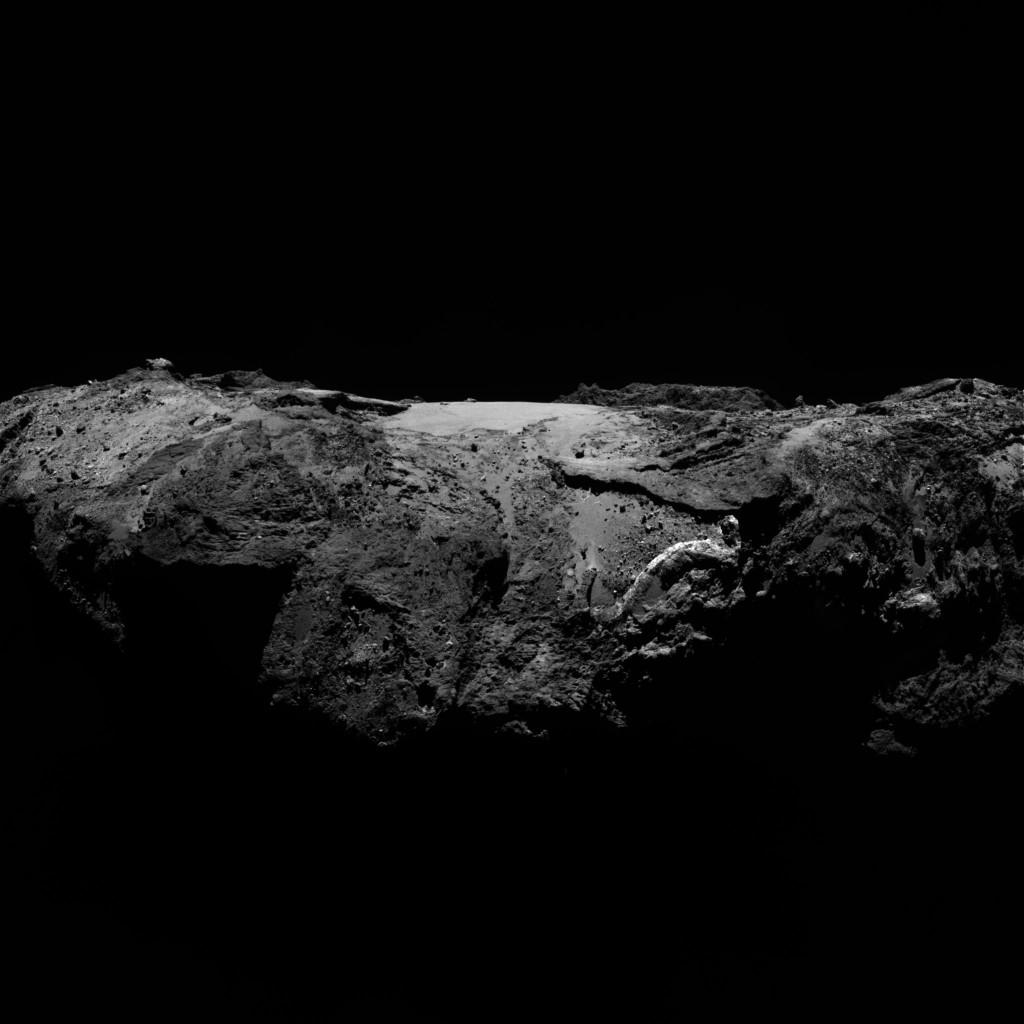
OSIRIS narrow-angle camera image taken on 2 January 2016, when Rosetta was 86.8 km from Comet 67P/Churyumov–Gerasimenko. The scale is 1.57 m/pixel and the image measures 3.2 km across. Credit: ESA/Rosetta/MPS for OSIRIS Team MPS/UPD/LAM/IAA/SSO/INTA/UPM/DASP/IDA
A particularly striking view can be seen in the image released on Wednesday (above) this week, showing an oblique view across the Imhotep region. The Anhur region in the southern hemisphere is in the foreground while Khepry lies to the far left and Khonsu to the right.
It is a picture of contrasts, with smooth terrain littered with boulders and surrounded by more rugged terrain. Examples of fractures and complex layering can also be readily found, especially when zooming in to the full resolution version.
Many previous images of Imhotep have given a bird’s eye view of this region, looking straight down, but this new perspective certainly helps to give a feel for the relative elevation of the terrain that bounds the smooth central plains of Imhotep. For example, the raised ‘cliff’ in the distance marks the boundary with Ash.
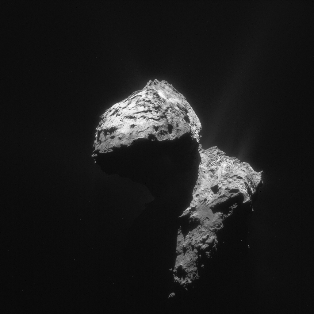
Single frame NAVCAM image taken on 7 January from a distance of 74.1 km. The image scale is 6.3 m/pixel and the image measures 6.5 km across. Credit: ESA/Rosetta/NavCam – CC BY-SA IGO 3.0
Rosetta’s NAVCAM also continues to provide stunning new views encapsulating the comet in its entirety: the image above was taken on 7 January from a distance of 74.1 km and captures a beautiful play of shadows falling onto the large lobe.
The comet’s southern hemisphere is also visible in this view, to the far right of both the small and large lobe. On the large lobe it is primarily Atum that can be seen in the foreground, with Anhur beyond.
On the small lobe a number of regions can be identified, notably Serqet, Nut and Maftet, with the relatively flat face of Wosret seen edge on. (Hint: use our comet viewer tool to help navigate the comet’s regions!)
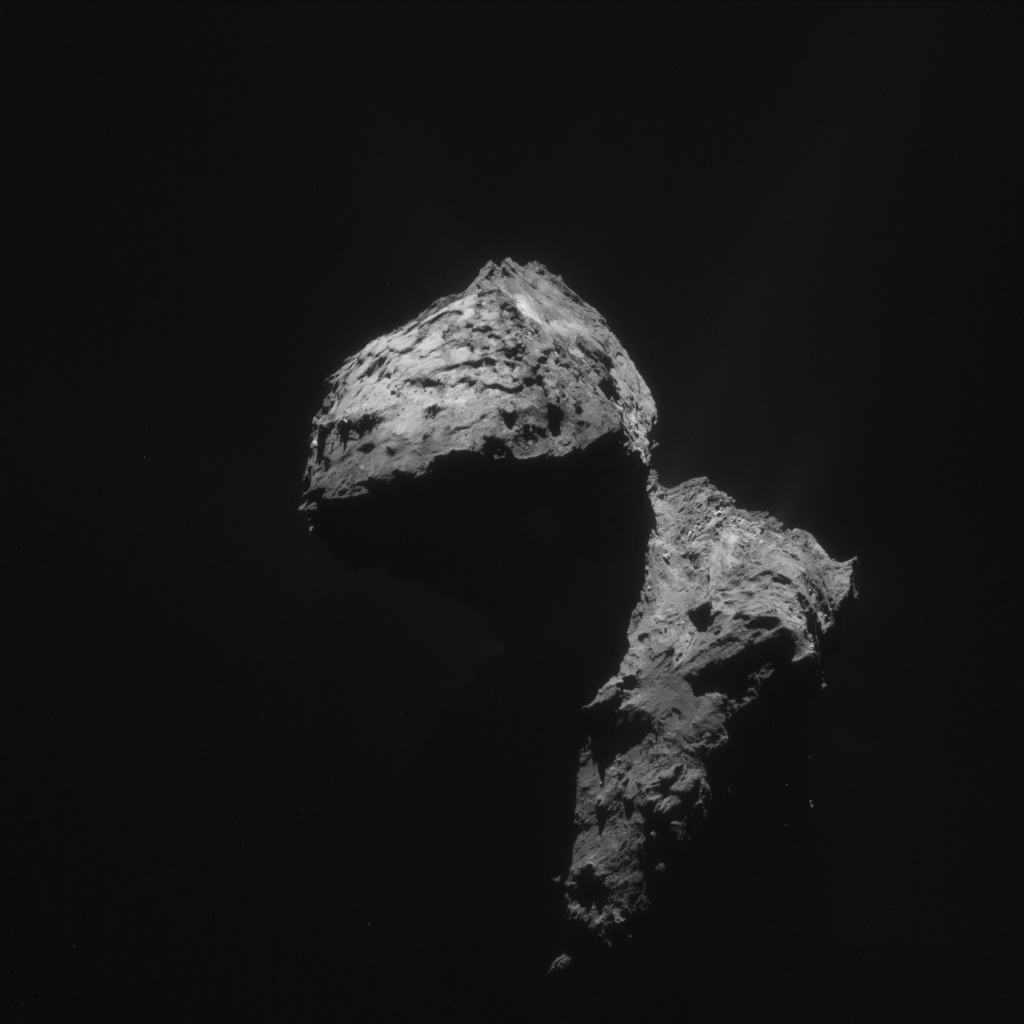
The original NAVCAM image is provided below:


Discussion: 16 comments
The first picture again asks more questions than we have answers.
Yes there looks like areas where surface ice can be sublimated, and yes there are weathered cliffs, but the rest of this view is so random.
There have to be other forces at work, witness the wavy strata, that does not actuall look so oniony, and the texture of the dark matt areas compared to dusty flat plains.
Also where the raised cliffs or strata lie, what leaves the pillar standing in the middle of the eroded wavy/courved feature?
It looks like there are more than 2 types of material, and the erosion faces look like there is an assortment of possibilities, including the much mentioned stretch theory and just about anything else.
I’m sure I’ve got a paper on this somewhere, but can’t put my finger on it at the moment. However, I see it as being similar to aeolian erosion on Earth. Totally different processes, of course, but areas of greater consolidation and/ or less ice close to the surface, will eventually stand proud of the surface, as other areas are lost to sublimation. I don’t think anyone has ever suggested that this is an homogeneous body, so no reason to lose material equally all over the body.
What would surprise me is if MIRO came back with thermal inertia values for any region that were in the range of
~650 J m−2 K−1 s−0.5. That’s what they found at the asteroid Steins; that would be rock; I would be gobsmacked.
So far they haven’t.
Hi
fascinating reading
I am not a science guy, so please forgive my ignorance.
Is collision a possibility for this area? definitely looks like a couple of scratch marks running in a South Westerly direction.
No need to apologize, Neil 🙂 These are the ESA Out-Reach blogs. Many of Us neither are [Scientists]. Definitively could be seen and interpreted like that.
Some of Us prefer the narrative of them being effectual voids of previous Comet’s activity.
Probably not Neil. There was a paper some time ago: https://onlinelibrary.wiley.com/doi/10.1002/2015GL064500/full
It’s behind a paywall, but the abstract pretty much summarises the mechanisms thought to be responsible for the fractures: “……which include thermal insulation weathering, orbital-induced stresses, and possibly seasonal thermal contraction. However, we conclude that thermal insolation weathering is responsible for creating most of the observed fractures…..”
Dave
This picture shows the rest of Anhur ‘just round the corner’ on the south pole:
https://www.esa.int/var/esa/storage/images/esa_multimedia/images/2015/12/comet_on_10_december_2015_from_osiris_narrow-angle_camera/15729183-1-eng-GB/Comet_on_10_December_2015_from_OSIRIS_narrow-angle_camera.jpg
At the bottom, it shows V-shapes that appear to have delaminated and slid down. The direction is somewhat towards the shadow which is the apex or turn between the south pole side and Imhotep side. The character of this area and its apparently sliding shapes is very similar to the character and shapes in this post’s OSIRIS photo. Especially the much brighter, curved section in this post that looks as if it’s slid across that smooth area from the darker section above it.
This means that this sliding (or behaviour that mimics the appearance of sliding) is happening in the same direction towards the apex of the turn. In cross section the two areascould be seen as being either side of a door stop (albeit a very stubby one) and sliding towards its pointed tip. The pointed tip is at or very near the tip of the long axis of the diamond-shaped body lobe and the rotation plane runs through the long axis. That means that for any given rotation period, these two areas will be subjected to the greatest centrifugal forces. It follows that if the rotation period were cranked up and up, they would be the first areas to exhibit sliding behaviour while the rest of the surface at smaller radii from the rotation axis would not slide. So what we see in this post’s photo and the linked photo is an apparent sliding behaviour that is wholly consistent with spin-up.
The same behaviour is seen on Seth at the other end of the body long axis. The apparent craters in that area are, in my opinion, delaminated sections spreading backwards towards Apis at the long axis apex. In that particular case, I’ve already matched the delaminated sections to each other. That was touched on in a recent comment to you and Logan regarding the apparent delamination of the layers on Atum towards Apis.
Thanks, Emily
I’m wondering where the exact south pole point is, because it would be useful to know. So here’s my guess with some reasoning thrown in because the NAVCAM photo in this post is perfect for illustrating those points.
In the NAVCAM photo, you can see how the body lobe is shaped into a very symmetrical diamond. Even with the left side largely in shadow, it’s traceable for half its length and can be safely extrapolated from there to meet at the tip. The tip is just below that lowest illuminated protrusion and it comprises a small, stubby rectangle, which is the Apis region. Apis is the tip of the long axis of the body lobe diamond shape and also of the whole comet when including the head.
The rotation axis certainly appears to run at 90° to the diamond’s long axis and across the short axis. It would therefore divide the diamond neatly in two, looking from above but it’s slanted down from upper left to lower right in this view. It’s even slightly slanted when the duck is ‘upright’. I think that slant is what makes the duck have a very slight tendency to rotate ‘right shoulder over left flipper’ rather than a neat ‘head over heels’.
So when the shape model is updated for the south pole, it will be interesting to see where the rotation axis emerges, thereby defining the exact south pole location. I think it will be somewhere near to a point that’s just above that very obvious right hand protrusion. That’s the short axis vertex on the south pole side. And it’s an interesting little area, lined with little troughs (50 metres wide and 100 metres long- estimated). These troughs look scoured out, rather like the ones in the head lobe cove directly above the north pole.
This OSIRIS NAC view gives me some rather vivid idea of how the view is like if I were standing at the centre of the plain of Imhotep. How beautiful is that!! Thanks for sharing this one!!
“…give a feel for the relative elevation of the terrain that bounds the smooth central plains of Imhotep…” Agree, Emily 🙂
Of note the few pixels at extreme bottom right. Quite probably an extension of those hard layer duo at right of body.
https://www.esa.int/spaceinimages/Images/2016/01/Comet_on_7_January_2016_NavCam
ROS_CAM1_20150727T064939
https://imagearchives.esac.esa.int/picture.php?/38473/category/167
This is a plane going all the way trough Ducky’s beak.
Hi OSIRIS Team 🙂 Beautiful image of the day.
This zone at the top of the shot has been very intriguing since the very first 3D OSIRIS published photo. A family of SPHEROID layering irradiates from missing mass above it.
This could be compacted, harder material.
NAC_2016-01-10T15.58.51.484Z_ID10_1397549008_F22
Forgot the link:
https://planetgate.mps.mpg.de:8114/Image_of_the_Day/public/OSIRIS_IofD_2016-01-18.html
Here’s the referred family of spheroidal layers:
https://www.esa.int/spaceinimages/Images/2014/08/Comet_on_7_August_b
Regarding the NAVCAM photo. On the head rim to the right, kissing the shadow of the neck, there are three shapes in a row. These match to three similar shapes below them on the body. These three body shapes are the three scallops that border the longish shadow with a straight top.
This is the fourth time this pair of three have shown up as matching and the fourth time I’ve commented on the match. Each time, the view is from a completely different direction. The first time, other commenters said it was probably an optical illusion and they needed views from other angles to confirm the match. This is the third such extra view.
For anyone who wants to make the match for themselves, there’s a bit of guidance below on the three head lobe shapes which are a little less obvious than the ones on the body. It takes a small amount of time and patience if you don’t visualise in 3D quite as well as Ramcomet and some others who see this quite readily. Then, scrolling up and down multiple times between the two sets allows you to see subtle mini matches within the main three shapes (eg the clover leaf that matches across).
A quick glance and a fourth brushing aside as vaguely matching or coincidental simply won’t hold up this time.
The head lobe set of three is angled towards us more due to being yanked up more vertically during head lobe herniation (according to the stretch hypothesis, not a mainstream view). That’s why the three shapes on the body are thinner. It’s because they’re slightly foreshortened across their width that’s running away from us towards the neck. The lengths, left to right, are the same though. With that in mind, the only section that doesn’t match to the body is the zig zag on the top of right hand shape- although the place where the zig zag should be is in shadow.
As regards locating the three head shapes on the rim kissing the end of the shadow: The left hand shape is slightly scalloped and a cross between a circle and a square. It’s like a circle that’s been pressed on four sides (but slightly pented on the top edge). There’s a dark shadow next to it to its right, obviously a recess, and that betrays the second shape below it and next to the left hand shape. That’s also kissing the rim, slightly smaller, and scalloped (though partially whited out). It doesn’t include the shadowed recess, it’s below it. It has a small, darker patch near its centre. The third shape is to the right of the second and runs to the end of the head lobe. It’s less obvious, longer and tapered with a zig zag along its top edge. It has an obvious clover leaf shape in its top left corner. The clover leaf is a mini match within the shape because it matches to the clover leaf in the same position in the same shape on the body.
Talking of shapes sounds quite naive as if there’s no accompanying explanation for them. In fact, the three head lobe shapes each correspond to an onion layer that’s flaked away (according to the stretch hypothesis, not a mainstream view). They’re on the head rim border of Maftet. They actually define that border because the flaking away is what made Maftet rough and Maftet was delineated as a separate region due to its roughness. The three flaked onion layers that the shapes correspond to are stepped down from each other. They run along the head lobe and join the strata lines on the more ‘vertically’ stratified Wosret region.
The three body shapes correspond to the continuation of these three onion layers on the body. You can see two somewhat more intact onion layers curving round the brighter area beyond them (to the right in the photo). The three body shapes would have been at the top of similar curves, nested to those two curves but they had their undersides ripped out. That’s why there’s a deep shadow directly below them. However, you can see the continuation of their onion layers below the shadow in the form of the zig zag line along the bottom of the illuminated section. Looking carefully, you can see the tell-tale fracture lines running up from each zig zag and those lines are directed through the shadow to join up with our three body shapes.
And, of course, both the head set of three and body set of three are touching the sharp turn to the south pole side on both lobes. And at that turn they join exactly to the matching lines I made on the south pole OSIRIS photo in December. Those two lines run all the way across the south pole to Bastet. And they in turn meet up with the matched lines that run right round Ma’at on the north pole side, across Anuket and join back up with these three shapes.
This set do a lot to explain the alignment body/head:
ROS_CAM1_20150609T053430
https://imagearchives.esac.esa.int/picture.php?/32362/category/139
ROS_CAM1_20150607T035002
https://imagearchives.esac.esa.int/picture.php?/32334/category/139
ROS_CAM1_20150417T223001
https://imagearchives.esac.esa.int/picture.php?/28893/category/119