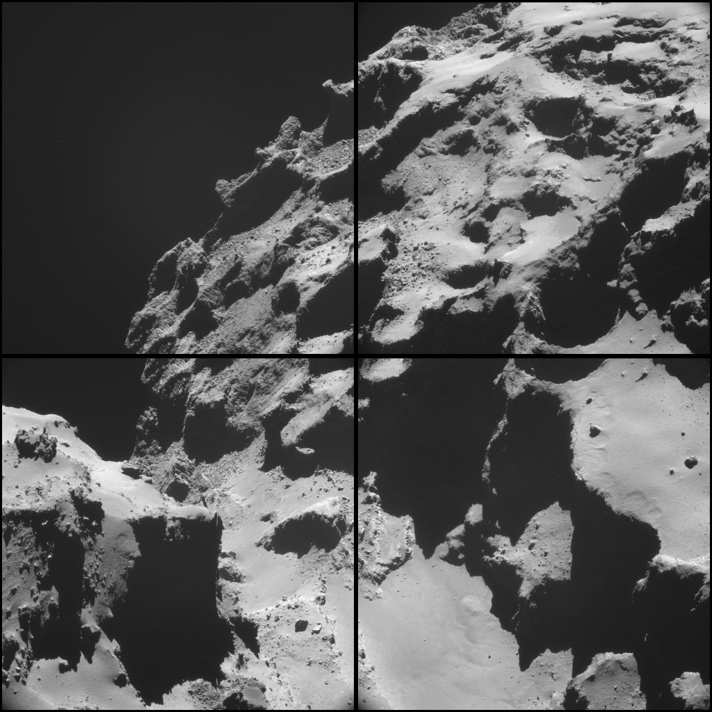
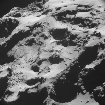
This four-image NAVCAM montage comprises images taken on 20 October from a distance of 9.4 km from the centre of comet 67P/C-G – about 7.4 km from the surface. In this orientation the smaller lobe of the comet is on the left, with the larger lobe on the right.
Assuming the 7.4 km distance, the image scale is about 63cm/pixel, so each 1024 x 1024 pixel frame is about 645 m across (although if we assume the furthest point away is an additional ~1 km further from the centre, the image scale is about 72 cm/pixel).
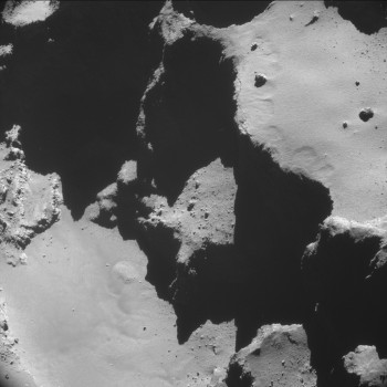
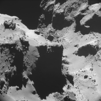
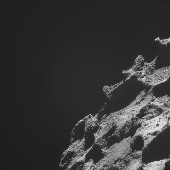
The four 1024 x 1024 pixel images making up the montage are provided below:



Discussion: 75 comments
Unless I’ve got it wrong, Emily. From your earlier posts, I’m assuming there are gasses etc being vented right in front of our eyes in this montage, but we can’t see them or where they’re coming from because of the contrast!
David
Amazing achievement by humans blessed with extraordinary intelligence.
Wow, thanks Emily! This is a really interesting perspective. You can see how erosion-like processes have “weathered” the features and how even micro-gravity causes the sediment to drift and pool in the low spots.
It is surreal how a world so alien can look so familiar.
Structures are even more regular as we close up…
Crystals rules the limits of emptiness.
Hi Jacob. Which are the forms of life more like crystals?
Emily,
How far across the gap between the head and the body, in this picture it resembles a ravine, how far across are the sides of the ravine between the head and the body?
RobertOkieInOKC
Hi Robert. The tops of the cliffs are about 1Km apart and the bottom of the ravine about 600-700m. The cliffs on the left go almost “straight up”. In reality there are two different “straight ups” in this image. For the right side of the ravine gravity’s direction is about 4 O’Clock, for the left side about 9 O’Clock. What is worse, its direction and strength changes along the length of the ravine on both sides. In addition there is a very small amount of gravity acting toward the surface of the valley.
The vast majority of the mass of the comet is in the two lobes, about 25% in the head (left), 70% in the body (right) and the rest in the neck area. As a result the body lobe is “pulling” at the edges of the head lobe. If you can make sense of what is “falling”, in which direction and from where, you are doing better than me.
Would be nice, if someone would bring that into some kind of sandbox, to play arround with, maybe some 3D Astronaut controlled via WASD, with Space as the “jump” key 🙂 your thoughts about the Gravity reminds me of the game “And Yet It Moves”
jumping from the Ducks Head, over to the corpus
Rosetta can take example of ground of this comet or two stones from its surface after and will fly to international space station.The cosmonauts can take this stones in orbit and return it in the Earth.
Interesting, almost spherical plume comes out of the comet in the upper left image.
https://imgur.com/Mk2jvTH
Cold ‘stream terraces’ all over the top right quadrant.
Logan’s def: stream terraces are featureless smooth patches next to ‘caves’ or shadowy walls. As if extra cold, slow and repting down gas were continuously leaking from the cold walls. Small amounts of ultra-fine dust in the gas. Even if clearly separated, they share the same leveling, which seems to be gravity commanded.
Too much aligned, same size ‘craters’ at frontier between top an bottom lefts. Aiming at the same point in the sky. Very different states of erosion.
Is this a battery of rocket launchers? 😉
Could bet the material inside those ‘rocket launchers’ is ‘younger’.
Hi Logan. This image is full of oddities and puzzles. The bottom three indentations which are half circles appear to be where “landslides” off the edge of the cliff have occurred. There are three separate piles of “rubble” beneath them on the floor of the valley. Next to them is the huge slice of cliff that has remained in tact and the point where it came from is a great gash in the cliff edge.
Hi Robin, on your comment:
“…The bottom three indentations which are half circles appear to be where “landslides” off the edge of the cliff have occurred.”
If you say it (you have an accurate ‘eye’) then I admit it as a possibility. But not discarding the argument of them being ‘impacted’ structures, originally adjacent to the upper ones, and of the same quality.
Hi Logan. I think on closer inspection they are impact sites with about a third missing. Very odd patterns on the floors and unusually not covered in “dust”. Too steep I guess.
That scenario I had not though off, Robin. Lateral impacts.
A mineralized ‘great wall’ going all the way from top right mosaic to center of bottom right quadrant.
This mineralized ‘great wall’ has to be part of the super-structure of 67P
As 67P heat up will be able to see more young material.
As 67P heat up will be able to ‘smell’ younger material.
I will let my toddle nephew to draw polygons over this mosaic 😉
P.D. And a big big ellipse over the top right quadrant.
Material deposited at the far right of this gorge which is the neck exhibit multiple geometries. Think it’s ‘core’ material. Here you have a probable neck’s jets source.
Core’s Material ‘grinding’ here. Just as Alter said it.
Just with NAVCAM! 🙂
It is a huge piece of highly structured material which seems to have formed as part of a plate or distinct layer. The view of one side of it is so distorted by “gas haze” and so pixelated it would not surprise me if it is a streamer source either.
The layered nature of the surface is very evident on the body side. Successive flows of molten and semi molten “ice lava” could account for this and create the plate like appearance of the pieces which have broken off. As speculated before some types of “ice lava” would have a very “blocky” cubic structure analogous to the Giant’s Causeway’s hexagons.
Think this material over the top facet of the neck’s ‘brick’ is eroded an fallen from the upper ‘rocket launchers.
Logan, I am thinking the “brick” is quite a bit closer than the “rocket launchers”. The back edge of it is so fuzzy because of the gas plumes. The rubble that appears to be falling on top of it is actually some way behind it and is the bottom bit of the “rocket launcher” that is missing above it. If they are impact sites then we can see the inside of the caldera without the Laktritz, which does not actually look very level. That part of the tunnelling impactor theory doesn’t look so good.
The three dark caves above are a better example. The cave in the middle is the first impact and a nice wall has built up round it. “Above” the cave, a large diamond shaped mound of material has grown beside which an almost completely eroded former impact site sits.. This mound is the fallout from the cryovolcano plume produced by the comets spin. The two caves either side are later impacts so they have destroyed part of the first caldera wall and built their own. They too have extra material in a mound “above” them.
I don’t have a fancy bit of software that tells me pixel coordinates, so this position is approximate. At about 700,160 in Image A is a structure of rock that matches the sides of the “brick” can be seen, just to the right of a bit of cliff that juts out to make a large shadow. Nearer to us is another bit of cliff that juts out. The gap between them appears to be where the “brick” has come from.
In my earlier post below (00:35) I mistook your “brick” for meaning the cliff wall of the head lobe, sorry for the confusion. I think the very light areas of rock exposed on the floor of the valley are recently exposed bits of the inside of the comet and are the source for a lot of gas and dust. We can see this in the image from 27th.
Once again Emily, Thank You! These stunning images of this tortured and fractured little world are captivating. This set are the best so far. We get to see bits of the comet we have not seen very much of before from this different view. The far end of the valley has always been out of site or hidden in shadow.
Good news. I have found Bob the Builder looking for his saucepan. On the left edge of image D about half way up. Just to his right is a nicely visible little plume of dust.
https://blogs.esa.int/rosetta/files/2014/10/ESA_Rosetta_NAVCAM_141020_D.jpg
The huge chunks of cliff that have fallen into the valley are the most incredible part of image A. On Earth they would have shattered and crumbled from the impact. Here the low gravity means they stay relatively in one piece, like massive shards of broken pottery. What a weird and fantastic sight that must be when one of those chunks separates and falls, a bit like large icebergs being carved off a glacier, only a lot slower.
https://blogs.esa.int/rosetta/files/2014/10/ESA_Rosetta_NAVCAM_141020_A.jpg
Also in this image there is another visitor. Right of centre about a third of the way up, peaking over the top of the light coloured ridge is YODA! You need to zoom in a bit to see his face.
That strange Laktritz stuff shows all it’s many facets in this set of images, from billiard table smooth bottom left image D, to dark and rough bottom right of image C. Elsewhere we can see the patterned rolling little mounds and bumps (image A, bottom left). The main feature of image D is landing site A on the right. Here we see the edge of the cliff with scallop shaped indentations in the surface layer as the surface layer is just starting to be eroded along with a large crack where another bit of the cliff is about to fall off. At the far end of the flat plain is a circular abyss, little Philae could quite easily have disappeared into that.
All that remains is the mess of rubble, craters and fractures that is image B. Quite amazing how these 4 images can encompass all these textures and landscape features in a couple of square Kilometres. You would be hard pushed to find anything even approaching this on Earth. A truly magnificent alien world. A big thank you to all the Rosetta team.
Amazing, any ideas how tall that cliff is in the picture ESA_Rosetta_NAVCAM_141020_A-350×350.jpg (The second one down) Just trying to get a sense of the scale.
@Brentj. A better idea of the height of that cliff can be seen in these images, where the cliff is on the right. From the scale of the images I would reckon about 1 Km.
https://blogs.esa.int/rosetta/2014/09/26/cometwatch-21-24-september/
https://www.esa.int/spaceinimages/Images/2014/10/Comet_on_2_October_NavCam
Another nice image for scale appears in a BBC News website article about the Philae column used in conjunction with the Rosetta stone. (Copied the idea from Bill definitely.)
https://www.bbc.co.uk/news/science-environment-29734975
Just watched the Rosetta film “Ambition”. Wow!
I noticed Mark McCaughrean was the Executive Producer. Nice one Mark. I noticed that the CGI for 67P were quite close to what we see in Rosetta’s images, did you and the filmmakers wait until Rosetta had some close up images before finishing this segment of the film?
This time, there are areas that don’t show obvious overlapping elements (and some pixels of the surface seems really missing for image stitching). So, we have decided not force the closure.
https://flic.kr/p/pN8Qvi
Thanks Elisabetta and Marco: Bags of pressurized gas slowly going up and spiraling at pixel 1607,1330.
Forming part of the ‘Great Wall’ super-structure.
Reinforcing ‘plasticity’ concepts 🙂
How many NAVCAM images a collected in a day or week? How many landmarks were defined on the comet 67P for navigation purposes?
Another detailed image for us! Somebody please stitch it together please.
Some very interesting details are emerging showing the form and shape of the Comets surface.
This image shows the eroded neck part and from my ideas it shows how ejected materiel is scattered over the surrounding areas.
At the moment we have several unknown functions happening on the Comet, the ejecta source and function, the low gravity effect of attracting the materiel back onto the irregular surfaces all at very low temperatures and over a very, very long time.
I also think that the surface materiel is probably like a pebbly beach, until we see detailed close-up from Philae it is hard to conjecture the fact that it is Dust? or larger materiel?
With the evident jets, it is more than likely that the Comet in its passage close to the Sun absorbs heat and it acts as a storage heater. This is then the output for the jets as it travels into darkness again. I would also imagine the core temperature will be shown to be quite high.
In a vacuum things are very different to what we accept and know at normal atmospheres.
Thanks again to the staff and Emily.
Hi Clive. ESA’s information on the temperature in the core of the comet is that it is between 30 and 160 Kelvin. The surface temperature varies between 200 and 220 Kelvin depending on the time of day and where on the comet you are looking, this indicates the nature of the surface in different areas has quite a large effect on the surface temperature.
Emily
Is there any chance of some comentary espisially on the white bits.
Are they hotter areas or are they a result pushing the contrast. Somebody must know.
They are increasing looking like traces of electrical activity if so these areas would show as hot areas relatively.
The crater at bottom right is positively swamped swamped with wispy White is this the start of a new crater?
If this shallow crater is hot and it is due to electric activity then we are about to see a crater deepen and form. The cliff above it also looks as though it is starting up.
Is there any irfa red from this area, madnetic field lines, current flow. Any information at all that could help understand what’s happening?
I think the whiter areas are just that tiny bit more reflective than the darker areas Dave. They might even be colder as they appear to be areas devoid of the thermally insulating Lakritz or surface powder. Matthias draped a long range infra red map over his 3D shape model so it is possible to see which areas are “hotter” than others. Unfortunately the resolution is very low, the data was gathered over 100Km out from the comet.
https://mattias.malmer.nu/wp-content/uploads/2014/10/VIRTIS_on_model.mov
The hottest area at that time was an area of the neck just below the area we see in this image, but is the one seen in the image with the dunes in and the long exposure OSIRIS image showing large amounts of surface and streamer activity.
https://blogs.esa.int/rosetta/files/2014/10/ESA_ROSETTA_OSIRIS_WAC_141020a.jpg
https://blogs.esa.int/rosetta/files/2014/10/ESA_Rosetta_NAVCAM_141018_D.jpg
Amazing images… is the surface covered by regular sand?!
Hi Valco. We the crowd still doesn’t know. We bet that even the scientists are not quite sure. They are finding a lot of ‘simple’ things, which is not the same as ‘regular’.
Please take a look at this -first plane- enormous ‘brick’ filing most of the bottom left quadrant.
The smooth upper and left surfaces. The regular ‘zigzag’ at the vertical border.
This ‘block’ seems to be the remnants of a filling between two ‘geological’ zones.
https://blogs.esa.int/rosetta/files/2014/10/ESA_Rosetta_NAVCAM_141020_A.jpg
The upper facet follows local gravity. The left one ‘mirror’ a no longer existent left lobe structure.
That huge cliff (Brick) is the underside of the head lobe we have seen in other images. The image below is taken roughly from the other end of the valley, with the body on the left and the head on the right. Landing site A, with its scallop indentations, is a good point of reference for orientation. The white “rivers” we commented on in this image are seen as the light formation in the centre of the bottom half of the mosaic above, in which Bob the Builder (twice) and Yoda are to be found.
https://www.esa.int/spaceinimages/Images/2014/10/Comet_on_2_October_NavCam
Unfortunately what can’t be seen in the 2nd October image are the sloping(?) darker, plates bottom left of the mosaic. Along the top of the cliff the colour of the Lakritz changes dramatically, then there is a ragged edge where the cliff edge has broken off. The large lump which broke off can be seen sitting at the bottom of the cliff, its darker coating in sharp contrast to the light valley floor. This looks like a pretty recent event, the surface coating of the lump has not had time to be eroded or made lighter by a new layer of lighter material, unlike other cliff falls elsewhere in the valley. Between the “sloping” plates, which are I think like Logan, actually just following the curve of the head lobe, is a tubular protrusion, Ptolemy’s Nose I shall call it, which looks to be a huge lava tube left un-eroded sitting on the plain.
As mentioned above, the gravity vectors in this area are extremely difficult to fathom, so interpreting slopes and their direction, is a hazardous exercise at best. This image probably encompasses a third or more of the circumference of the neck, so areas of the valley at the top and bottom of the mosaic have a huge change in perspective and elevation compared to the middle. I bet ESA are regretting not making the NAVCAM and OSIRIS cameras stereoscopic.
Hi Robin. Good to go back to this photo. Now can say with a lot more confidence. The ‘linearity’ of both walls is beyond any ‘pile of ruble’. This particular photo you point at forces me to think both lobes belongs to a single former object.
“…about 25% in the head (left), 70% in the body (right)”
So beautifully ‘drawn’ as a curve of gravity on the neck horizon of this photo you are signaling 🙂
I was so busy trying to explain what was going on with gravity that i missed the obvious indication of what was happening, the valley floor’s shape. Also looking at the photo again, the areas of plasticity and flow are very similar at the top of the image on both lobes either side of the valley. It does look more like a huge trench has been dug into a single object.
The impact event that created Bill’s “Amphitheatre”, looks to have created a huge tunnel into the comet. The remains of some of the resulting volcano and tunnel walls can still be seen as the “great wall” structure and the cliffs making up the walls of the Amphitheatre. i commented elsewhere that these walls and cliffs looked like the inside of the comet.
Not only would the impact explosion have ejected huge amounts of material but the cryovolcano created would have vented huge quantities of material from the centre of the comet. This would have exposed the more volatile ices in the centre of the comet also. This would be the start of the rapid erosion of the neck area. Just a theory, but there has to be some reason why the neck area initially started eroding quicker than the rest of the comet.
It does appear the streamers in the neck area scour the comet material away to create the majestic straight sided cliff of the head lobe. If the streamers are some form of cryovolcanism on a smaller scale, then the streamers would be relatively hot compared to the surface of the cliff and hence cause more rapid sublimation. If the dust is made mainly of silicates and other minerals, it would have an abrasive impact, the cliff wall in effect being sand blasted away, as well.
A. Cooper suggests the single body has been “stretched” by a close encounter with Jupiter and notes how some features are connected on the head and body. A contact binary is looking less and less likely.
“… It does look more like a huge trench has been dug into a single object. ”
That’s the image on my mind. A common mind. Thanks Robin.
🙂
Wishlist for next Rosetta:
It has to bring back the StarDust concept. Copper rail-gun. Some form of electron cloud energizing of the ejecta. (aiming laser, maser, radio, etc). Such that we can have emission spectrometry of shoot ejecta.
Or a small ‘shutting’ Phylae. Against the sun light. Such that we can have absorption spectrometry of shoot ejecta.
Is in the flight plan a lapse for ‘coronary’ spectrometry?
A comparative series of images showing “The Ampitheater”, a topographic feature in Image “A” of this montage series–
https://univ.smugmug.com/Rosetta-Philae-Mission/Rosetta-Comparative-Series/i-WtMMGWd/0/L/compar–%20ampitheater-L.png
An illustration showing the gravity equipotential surface over “The Ampitheater”–
https://univ.smugmug.com/Rosetta-Philae-Mission/Rosetta-Geomorphology/i-4FbrR9h/0/L/NAVCAM_20140926_A–slope-gravity_annot-L.png
Further discussion “In Reply”…
–Bill
The montage series of Navcams of 20 October are showing interesting detail. Particularly so is the “D” exposure of the montage, which shows mass wasting on the edge of the feature informally named “The Ampitheater” near the north pole. Visible are several scars where the loose dust has slipped off the side of the bluff.
This is what I think is happening: as the comet warms the gases sublimate, carrying fine silicate and “nonvolatile organic material” away from the surface. Some of the material does not achieve escape velocity and falls back to the surface, evident as the smooth terrains that drape over the underlying surface. We don’t know the exact nature of this material yet, but it is likely composed of micro- and nano-sized particles of silicates and organic compounds, and is very fluffy with low density and loosely compacted with minimal strength, although I suspect that electrostatic attraction and van der Waals forces may create some degree of cohesion.
The dust jets observed at The North Polar Plain create a rain of fine particles that cover the adjacent bluffs. As long as they are not in an active sublimation area and are on flat ground, these deposits will remain stable indefinitely until conditions change. However, on a small body like this comet, down is not always down and the direction can change over a short distance depending on the distribution of adjacent masses. The resultant gravitational vector is related to a “gravity equipotential surface” and is described by red line and the perpendicular vectors on the attached illustration.
https://univ.smugmug.com/Rosetta-Philae-Mission/Rosetta-Geomorphology/i-4FbrR9h/0/L/NAVCAM_20140926_A–slope-gravity_annot-L.png
Note that although the floor and draped deposit of “The Ampitheater” is flat, near the edge of the bluff the effective topography beomes a slope due to a change in mass distribution at the bluff. This draped deposit builds up, and when a certain density is reached, the resultant forces exceed the shear strength and cohesion of the material and a slope failure occurs. The material moves as a fluidized flow until the point is reached where the resultant slope levels out, away from the bluff. This is seen in several crescentic scars, outlined in yellow on the attached. Two boulders provide an anchoring force for the draped deposit and give the appearance of “dust tails” behind the boulder.
There may be actual dust tails behind some obstructions, but at this point we do not know enough about aeolian processes in low-gravity, near-vacuum environments to say for sure. Hopefully as the comet warms and degases, we will be able to observe these processes firsthand and gain a better understanding.
Also visible are deposits at the base of the cliffs with particle sizes ranging from coarse to very fine, presumably created by material falling from the cliffs. Although, on the floor of the “North Polar Plain”, some of this underlying material may be deposited by vent processes.
Attached also is a comparative series of images of “The Ampitheater” from August to October 2014. This suggests that the slope failure scars and the deposits at the base of the cliffs have been there and (relatively) unchanged since the arrival of Rosetta.
https://univ.smugmug.com/Rosetta-Philae-Mission/Rosetta-Geomorphology/i-4FbrR9h/0/L/NAVCAM_20140926_A–slope-gravity_annot-L.png
–Bill
I apologize– that last image link in the previous (27 Oct) message was wrong– a repeat of the other link.
That last paragraph with correct link should be:
===
Attached also is a comparative series of images of “The Ampitheater” from August to October 2014. This suggests that the slope failure scars and the deposits at the base of the cliffs have been there and (relatively) unchanged since the arrival of Rosetta.
https://univ.smugmug.com/Rosetta-Philae-Mission/Rosetta-Comparative-Series/i-WtMMGWd/0/L/compar–%20ampitheater-L.png
===
–Bill
Thanks Bill. I tried to explain in words, but this is better. Some cliff edges seem to slip gently down the side of the cliff, others see to break off in a clean lump. On the head side the lump has landed away from the cliff. On the body side, landslides and slips seem more prevalent. An effect of gravity variations I think. The larger mass of the body pulls falling objects away from the head and pins them to the cliff face on the body side. I speculated this could be the case earlier, this image seems to show some evidence that theory might not be too wrong.
The lines of rocks down the centre of the neck valleys would seem to mark where the opposing gravities of the lobes are at equilibrium and the small mass of the neck is dominant. They do seem to line up nearer the body lobe. Its difficult to say, as we rarely see both the cliff bottoms not in shadow at one time.
If the circular/oval flat areas were once liquid, the smaller ones could be used as a guide to which way the gravity vector is acting. Alternatively if they do all align, it could be good evidence that these once were areas of molten comet material. I’ll leave the ESA folks to do that, I get way too confused.
Robin, I tried to illustrate just that in another post. At one time I was supposing that the line of boulders was too coincidental, even with the gravity gradient, and proposed that the boulders were a line of “sand volcano-like” structures along a fracture. Maybe not, but the drawing that shows the gravity gradient is still valid:
https://univ.smugmug.com/Rosetta-Philae-Mission/Rosetta-Dust-Jets/i-S7Px23L/0/L/northplain_x-section-L.png
And there are several other images, some annotated, in the “Dust Jets” gallery of my comet site:
https://univ.smugmug.com/Rosetta-Philae-Mission/Rosetta-Dust-Jets/i-DHNvtXr
–Bill
Logan’s point about the gravity vectors defining the shape of the valley to a large extent, is a good corollary to that idea. When the images you are referring to were first seen it was very difficult to determine what were “boulders”, “rocks” and vents because of the low resolution and I remember your theory making some sense at the time. It is nice to see these close up images solidifying some of our tentative theories. Still a bit disappointed we can’t find evidence for the source of these streamers.
I also liked your explanation for the scallop shaped indentations on the edge of the Amphitheatre floor. We saw these shapes before and there were vents with gas plumes close by which had actually scoured the surface layer away back to the solid surface. These are different, the surface layer has not been totally removed and there is only one obvious area of rapid sublimation. Once explained, the reasoning matches the image nicely. I have been surprised we have not seen more of these dust slides all over the comet and I think mentioned it before. They do rely on gravity though and that is so fickle everywhere, so perhaps not so surprising.
That’s a lot on so little, but my mind tend to agree with Bill and Robin in almost all of the arguments as plausible.
Detail: “The lines of rocks down the centre of the neck valleys” seems to me as ‘fallen’ from the top of the cliff.
Suppose there was a force 10^(39) times as strong as gravity – oh wait THERE IS! This will account for almost ALL of the surface topology AND predict the ‘dust’ plumes will be normal to the surface.
Here we have an object that was in a different electrical environment moving into a new one which should result in large field gradients forcing loose ‘dust’ to leave the surface along the field lines.
Think Electric – we live in an Electric powered universe. Gravity is a side issue.
BTW did you all know that the speed of gravity interaction must propagate at least 10^(10) times the speed of light? see::https://metaresearch.org/cosmology/speed_of_gravity.asp for an excellent discussion..
This can be easily tested. Such huge forces would launch ions at very high speed. We’ll know when data released.
Nice pictures Bill, are you a geologist, it would be good to hear from a few.
The picture showing the slope failure, is difficult to assess, it may be the shadows, but even though it looks like slope failue, the piece on the floor does not seem to fit the bit its come from.
I have no other solution though.
I am a Geologist. My career was in mineral exploration and environmental, with a background as a geotechnical grunt in engineering geology, but I have been an “amateur planetary geologist” since the 1960’s. 🙂
This is interesting. We are getting many puzzle pieces to this mystery, and bit by bit we get “ah-ha” moments.
–Bill
One might suppose the newly exposed edges of cliff and missing piece, would erode more rapidly and at different rates so an exact match might be difficult. The fallen bit of cliff at the bottom of the bottom left quadrant seems to be a recent event and I reckon matches quite closely to the bit missing at the top of the cliff.
I can not imagine gravity is the cause of these cliff falls, fractures appearing in the cliff material seem to be the explanation. How those cracks are generated is more open to interpretation. Comet quakes, tidal stresses, temperature changes from night to day, expansion pressure from the release of gases inside the cliff, impacts, electrical effects, weak spots created by sublimation, take your pick. I have seen little lines of dark pits starting cracks, so gas venting from inside the cliff is my theory.
In an earlier picture of August 7 (rosetta02_esa_2048 posted in APOD) I saw an interesting rock in the plane situated on the top right side at the bottom of a cliff. It seems as if a straight feature is emanating from the rock. Is there a close up picture from this area from another point of view?
Hi Guenter. Indeed there are close up images. That crater you see is one of the 5 initially proposed landing sites, Landing Site B. This is an OSIRIS image about 1Km across showing that feature. It looks like a ridge, probably many metres high. Hope this helps.
https://www.esa.int/spaceinimages/Images/2014/08/Candidate_landing_site_B
Hi Robin
I looked now several times at the two pictures and I still have difficulties with the orientation because the rosetta02_esa_2048 has been taken under a strong perspective and on the picture of landing site B its hard to find familiar structures. The feature I referred to was rather small so I don’t think it was a cliff. Thanks anyway for your help.
Dennis that is excellent, very interesting
David
Hi Bill, on the picture release on the 24th, on the top right hand side, one of the flat craters extends to a flat runway for the want of a better word, but the runway over hangs a cliff by about a 1/3 of its length.
It certainly looks ready to colapse, although I guess gravitational effects are minimal.
In such a carved environment, it looks at odds because it seems the only runway with such a feature. Probably any weaker material that was originally underneath it has eroded away, was it a missing lump of ice maybe that has sublimated away, or is it the effect of the so called solar wind.
I struggle with the sharp and distinct undercut, it would seem difficult to have layers of different strength materials like on say earth, when there does not seem to be a method of producing them from the dirty snowball idea.
As I said before I am no geologist
It just looks that way. This “flat crater” is candidate Landing Site A, informally named “The Ampitheater”.
I have a comparative series of image of this feature:
https://univ.smugmug.com/Rosetta-Philae-Mission/Rosetta-Comparative-Series/i-WtMMGWd/0/L/compar–%20ampitheater-L.png
which gives a better idea of it’s geometry. The south-facing bluff is always in shadow and is hard to visualize.
–Bill
Fantastic images special about the boulder locations related to the imaginary center of mass. Or is it dual centers of mass?
hola que tal soy de brasil me gusta mucho astronomia estoy estudiando
me gustaria de saber se hay algo que puedo estudiar en esa
gracias
Scenario launch:
While moving ‘Laktritz’ acts as a ‘mirror’ ‘sander’.
Remember glacier erosion? Not U shaped here, but ‘terrace’ shaped.
Visual evidence:
Center right of
https://blogs.esa.int/rosetta/files/2014/10/ESA_Rosetta_NAVCAM_141018_D1.jpg