The first blog post of the series ‘Defining the sustainability of space activities’ has been written by Romain Esteve following its presentation at the 2017 Clean Space Industrial Days. Romain studied the assigning of economic value to orbits following in-orbit collisions during its internship at ESA.
Author of this post: Romain Esteve
Every space debris specialist will agree that it is crucial to determine which orbital region is the most sensitive and what are the most dangerous items of debris. Their threat is usually accounted for in terms of collision/explosion probabilities (polluting potential), potential damage to active spacecraft and risk of causing casualties on the ground. The literature shows increasing consideration for ‘indexes’ for space debris. These indicators measure the level of threat according to several characteristics. As an economist, my job was to add the key element of ‘value’ to debris indicators.
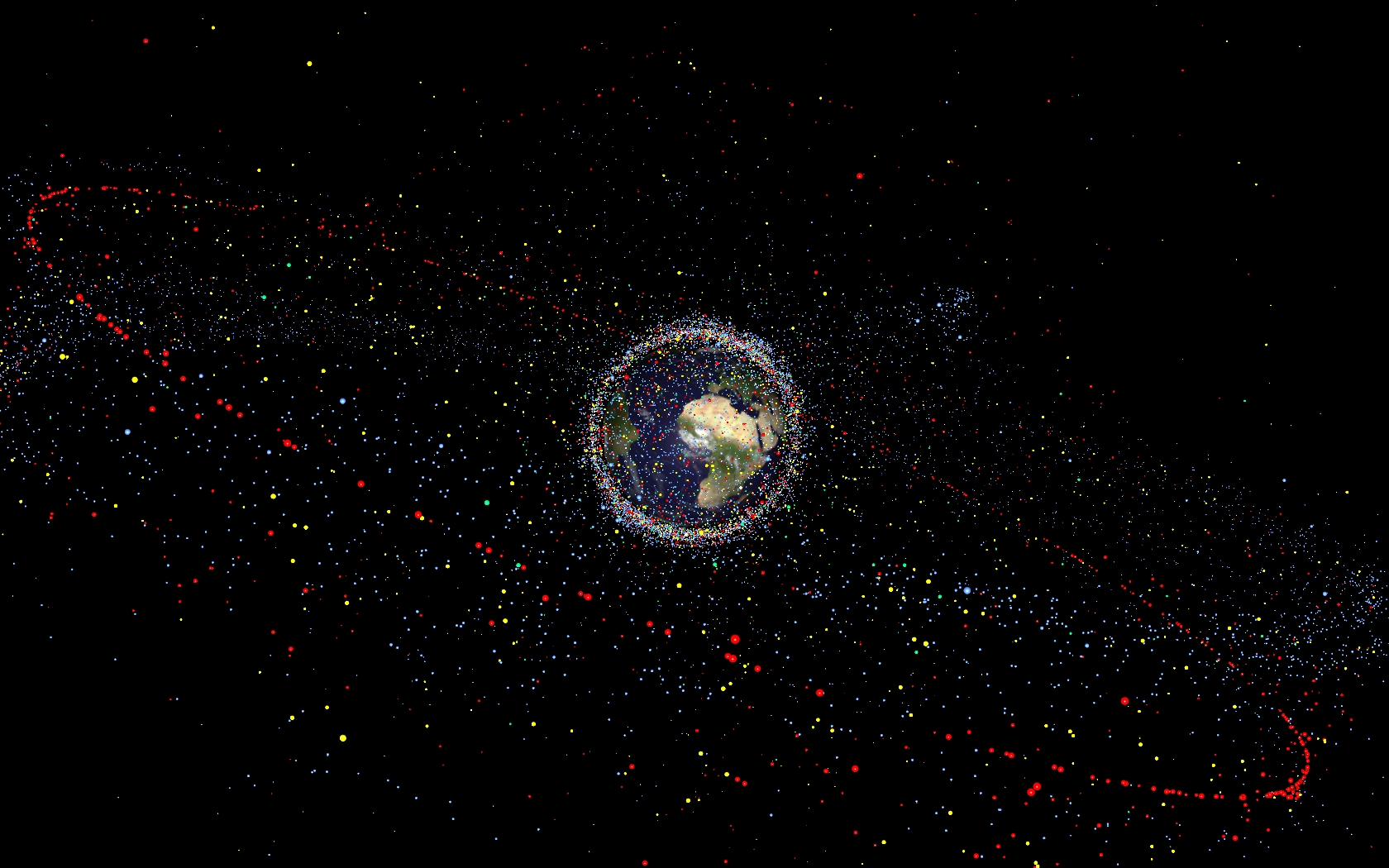
Distribution of debris around the Earth
Credits: ESA
Quantifying externalities
Considering a short-term period of 10 years, I looked at the post-collisional effect of space debris. Take any debris as an example; when a collision occurs, the result is a cloud of debris in which the amount of smaller elements depends on the mass of the object. Hence, there is an increase in the debris density (flux) around the impact point. The polluted area may contain active satellites that contribute to a lot of different applications on Earth or in space: in other words assets that are creating economic value thanks to the information they provide to users. Economic theory has recently seen a surge of interest in the value of information as a way to quantify non-monetary value. Moreover, it is also helpful in quantifying heterogeneous economic variables.
Looking at the Sun-Synchronous Orbits (SSO) region, one can identify different satellites that serve different purposes (Earth observation, space science, etc.). For each of them I tried to determine the key elements of the value of the information they provide. I determined three main characteristics:
- The outcome at stake: monetary and non-monetary values depend on the direct application of a spacecraft. Earth observation satellites can help saving money thanks to better management of water in agriculture or generate revenue for VAS (value-added service) companies that use their data. For scientific and demonstration satellites the value can be measured in the number of publications based on data from the satellite. (π_j)
- The cost of information: factors to consider are whether the data is free or not, and that the demand for images with a certain quality will decrease as the price increases. (C_j)
- The second-best substitute: drag down of the value as it is possible to find cheaper, more easily processed or better quality information; in the case of weather forecasting for instance, users might be better off buying data from in-situ measurements rather than from satellites. (S_j)
In practice
The three previous characteristics can be extracted and extrapolated from different sources for a subset of over 140 SSO satellites. By combining all values it is possible to build a comparative valueless index:
Value = αSj + βCj + γπj
{α, β, γ} are determined following a singular value decomposition method and applied to all satellites in the data set.
After this process and considering the post-collisional dispersion of a cloud within 10 years, it is possible to measure the impact of a single piece of debris. The ‘Steve Index’, SI, is a combination of the expected number of debris I_Ρ.Μ, the total mass of other debris I^deb ; and the total value of active assets I^sat ; in the cloud range (normalised with respect to a reference debris Ī_Ρ.Μ , reference mass Ī^deb and reference asset value I^sat . These reference values are computed with respect to a dummy satellite placed deterministically following the existing literature and the data):

To illustrate how this model works, let’s take an example involving a heavy spacecraft with a mass of over eight tonnes in the SSO region. If a collision occurs the resulting cloud would have an impact on the orbit:
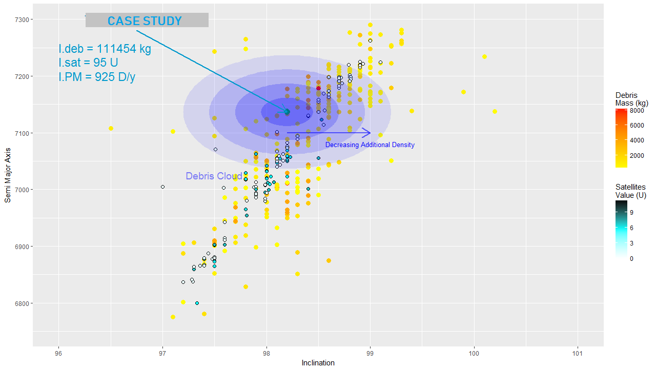
The blue is getting lighter and lighter further away from the debris-causing spacecraft’s position, illustrating the decreasing added density caused by the debris production. All the objects inside the ellipsoid will suffer from an increased risk of collision due to the increased debris density. In this case the spacecraft is threatening 33% of the total mass of debris (thus possibly increasing the amount of debris further due to inter-debris collisions) and 23% of the total value of the active satellites (for the given data). Removing this potential source of debris would not only improve the quality of the orbital region and lower risk for the surrounding objects but also reduce the total mass of objects is the SSO region. Deorbiting the satellite would represent a reduction of 12% of the sum of the expected number of debris.
Ranking debris with a new index
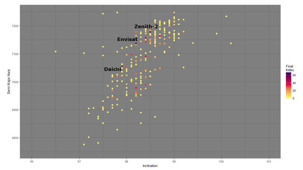
The complete calculation model gives interesting results: only a few satellites it indicates as drivers of increased risk to SSO employment show up as significant in rankings based on physical and orbital characteristics alone. This means that economic and environmental characteristics are game changers in the way we prioritise dangerous objects. It opens a new question: what debris should be considered as the most important? It is difficult to choose whether a higher weighting factor should be attributed to collision probability or to economic consequence. However, when merging these factors together, it is possible to determine which satellites have the most important impact on the aggregated variables, as shown in the graph below.
Conclusion
For Active Debris Removal (ADR) missions, future targets should be chosen in accordance with social-economic interests. In my Master’s thesis I showed that depending on the location of the debris, the consequences of a break-up are different and more worrisome for certain locations. I introduced an index for space debris that considers economic and environmental parameters alongside the traditional engineering index based on collision probabilities and mass alone. Also, I proposed an evaluation method that tries to measure the performances of satellites based on their characteristics. The methodology could be improved on several levels, such as more accurate measures of the value chains, weighting the debris and satellite indexes in accordance with preferences of policy makers and users, enlarging the data set used, and much more.
Nonetheless, it is clear that Earth orbits are a common pool resource that will not be excluded from tragic depletion if behaviours do not change in the near future. Stabilising the production of debris begins with compliance to mitigation guidelines proposed by international agencies and must be followed by active debris removal to deorbit the most dangerous and influential debris items. This is why it is important to define properly the resource we are exploiting and quantify externalities in order to make space a sustainable environment.
Related content:
- Macauley, M, The value of information: Measuring the contribution of space-derived earth science data to resource management
- Colombo et al, Life cycle assessment indicator for space debris
- OSCAR (database),
- European Commission, Study to examine the socioeconomic impact of Copernicus in the EU – Full
- Defining the sustainability of space activities


Discussion: 2 comments
You consider the value as contributory, yet one other aspect was not considered: the value of the material of the debris. Scrap of metals and reutilization of components may eventually be the driving factor of cleaning up near space. If there is money to be made, industry will find a way to capture it.
you are great!