


On 25 January the GLORIA instrument took the first ever tomographic dataset to infer the 3D temperature structure of a mesoscale gravity wave. This, however, does not only depend on having a novel instrument and the presence of a gravity wave in the lower stratosphere. In order to measure exciting gravity wave structure a lot of planning and also some luck are needed.
GLORIA is an infrared imaging spectrometer for remotely sensing Earth’s atmosphere. It was developed jointly by the Juelich and Karlsruhe Helmholtz Centres. GLORIA’s unique ability to pan the line of sight from 45° forward to 128° backward with respect to the airplane’s nose makes it well-suited for tomography. GLORIA measures atmospheric temperatures and about 20 trace gases.
Monitoring the forecasts
To plan the flights we need to know several days in advance, where an interesting situation is likely to occur. We look into the temperatures predicted by the European Centre for Medium Range Weather Forecasts, but not surface temperatures – we need to know that they are going to 12 km high. We search for wave patterns, alternating cold and warm bands. We start five days in advance. We found interesting gravity wave structures several times in the five-day forecasts which, however, dissolved again. On 22 January, however, we are quite certain: An interesting case would develop over Iceland for 25 January.
Generating a flight plan
We set to work. In order to reconstruct the 3D structure, we need to do tomography. The principle is the same as for x-ray investigation in medicine: we need to consider the target (here our gravity wave) from all sides. The optimal configuration for this is to fly a hexagon. This pattern is shown in the figure. The position and orientation of this hexagon is the first part of the flight planning. In addition, we plan a long linear flight leg right through the centre of the hexagon. From this leg we release drop sondes, small sensors on little parachutes which send the temperature and wind information below the airplane to be recorded on HALO.
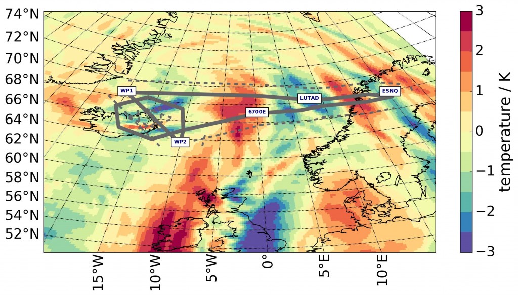
Flight planning for GWEX. (P. Preusse)
The sketch of the flight plan is shown in the picture. Smaller scales in the temperatures at 12 km altitude. Long-drawn, wave like bands are seen for instance across the Norwegian coast. We are particularly interested in the waves above east Iceland.
The crew of DLR-FX, who operate the airplane, now use this scientific idea to generate a preliminary flight plan in the system of the air traffic control (ATC). Once ATC accepts the flight plan, we are allowed to fly the proposed route.
Ground weather
The Kiruna airport does not support fully automatic landing of the airplane. This means HALO can only take off and land when there is good visibility on the ground. We have some doubts whether there may be fog in the afternoon. We hence shift the take off to an earlier time of 08:00. This means some instruments have to be prepared for flight starting at 04:00. At 06:00 we meet in the pilots’ room. Just when we discuss the weather situation, at 06:15 the weather forecast is updated. The fog warning for the landing time disappears. We decide for “go”.
Signs for gravity waves during the flight
Already in the flight we see indications of gravity waves. Several trace species show wave-like features. Also, in the infrared pictures of GLORIA wave features. The pilots have to regulate the engines manually to compensate quickly for the variations in the head wind.
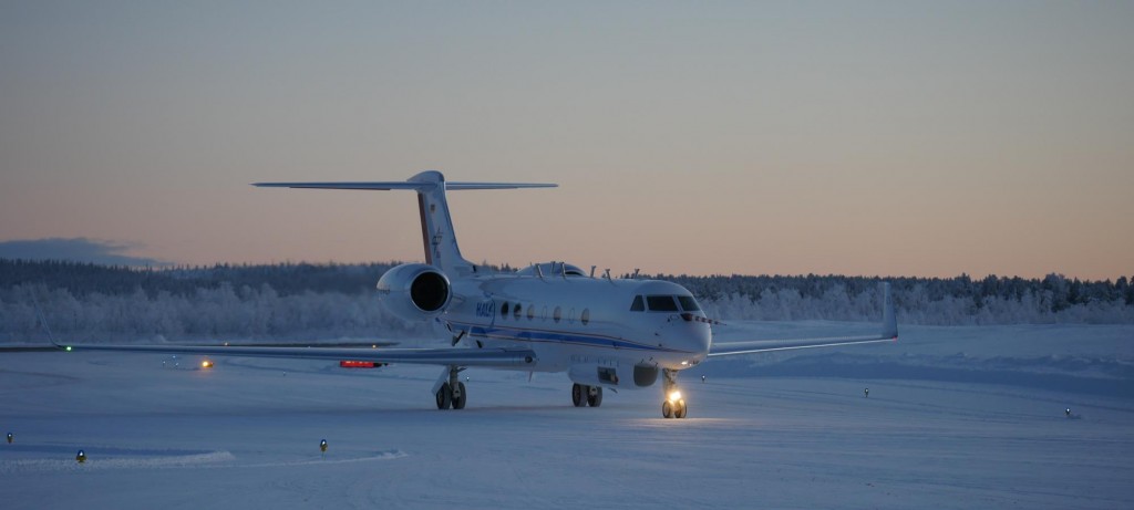
HALO back on the ground. (P. Preusse)
HALO landed after a successful flight
After a seven-hour flight, HALO comes back to Kiruna. The picture shows the plane after landing. We start to get the first data, and to process some quick looks over night. At about 5 o’clock we drive home. Fog is closing in on Kiruna. We were lucky – and we are happy. There are data to evaluate in the next months to come.
From Peter Preusse (FZ-Juelich)
Editor’s note:
Gravity waves were studied as part of the Premier mission concept, which was a candidate for ESA’s 7th Earth Explorer. One of the conclusions of studies related to the concept was that general knowledge about gravity waves is limited and that they are difficult to measure and model. It was also concluded that measurements would be very helpful in order to observe these waves as they form in the atmosphere. For this reason, ESA carried out the GWEX gravity wave experiment, which focused on detecting gravity waves. It is part of a larger campaign called POLSTRACC looking at processes in the polar stratosphere and carried out by different German research institutes such as KIT, DLR and FZ-Juelich.
Discussion: no comments