*This post provides live updates from ESA’s Space Debris Office on the atmospheric reentry of ESA’s ERS-2 satellite. New updates will be added at the top of this page, so check back daily for the latest.*
For more information on ERS-2 and this reentry, see our ‘ERS-2 reentry – homepage’ and ‘ERS-2 reentry – frequently asked questions’ pages.
Data direct from ESA’s Space Debris Office can be found here (free user account required to view).
— UPDATE 21 February, 20:30 CET —
We have confirmation of the atmospheric reentry of ERS-2 at 17:17 UTC (18:17 CET) +/- 1 minute over the North Pacific Ocean between Alaska and Hawaii.
Click here for the coordinates via Google Maps.
— Update 21 February, 18:35 CET —
We have now reached the end of the final reentry window. We have received no new observations of ERS-2. This may mean that the satellite has already reentered, but we are waiting for information from our partners before we can confirm.
— Update 21 February, 17:45 CET —
This is likely the final update prior to the reentry and break up of ERS-2. Consider following @esaoperations on X (formerly Twitter) for any further info.
ESA’s Space Debris Office currently predicts that the reentry of ESA’s ERS-2 satellite will take place at:
17:05 UTC (18:05 CET) on 21 February 2024
The uncertainty in this prediction is now just +/- 0.55 hours.

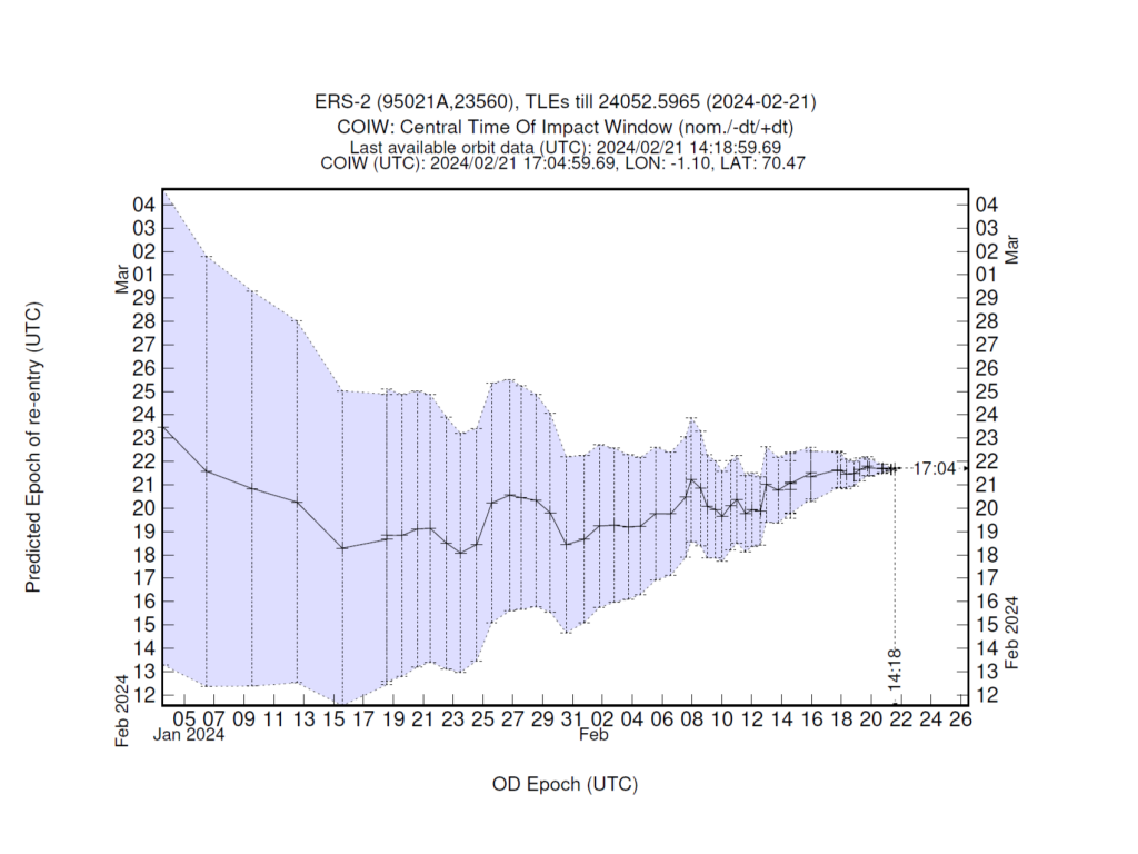
This is the latest graph showing how the predicted time of reentry has changed over the last month and a half. As we approach the reentry, the uncertainty in the prediction decreases.

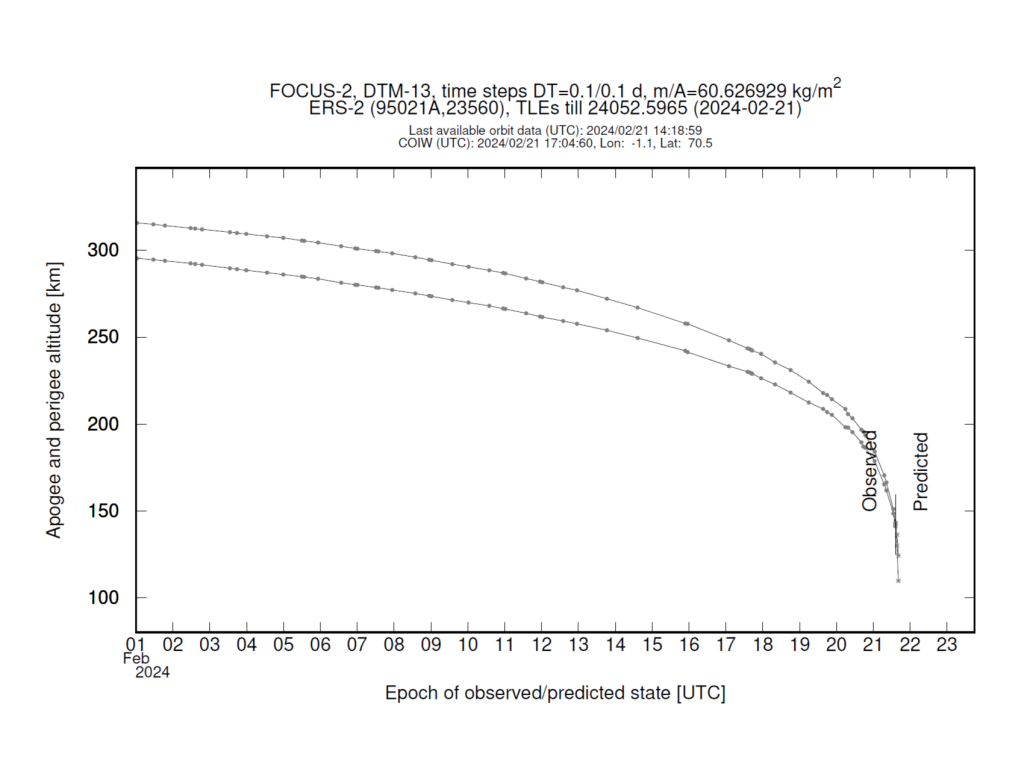
This is the latest graph showing how the altitude of the ERS-2 satellite has changed over the last month, and how it is expected to change in the future.
As ERS-2’s orbit is not a perfect circle, two lines are shown:
The upper line shows the satellite’s ‘apogee’ – the point in its orbit at which it is further from Earth.
The lower line shows the satellite’s ‘perigee’ – the point in its orbit at which it is closest to Earth.
At any particular moment, ERS-2 is at an altitude somewhere between these two lines.
Values before the vertical line show real data obtained via observations of the satellite made using sensors on the ground.
Values after the vertical line show how the satellite’s altitude is expected to evolve in the future, until it fragments into pieces at an altitude of roughly 80 km.

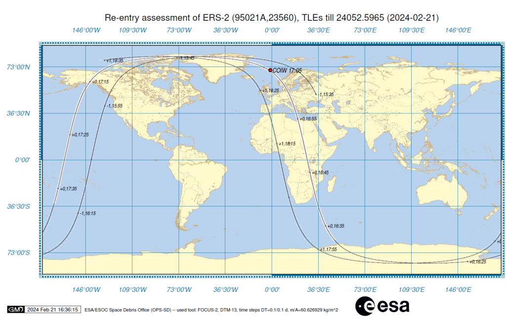
This is the latest available ‘ground track’.
At the current predicted time of reentry, 17:05 UTC , 21 February, ERS-2 will be located approximately 80 km over the red marker, labelled COIW (centre of impact window).
It is here that we currently expect the satellite to begin to break up. The vast majority of the satellite will burn up, and any pieces that survive will be spread out somewhat randomly over a ground track on average hundreds of kilometres long and a few tens of kilometres wide (which is why the associated risks are very, very low).
Reading the ground track:
ERS-2 could still reenter at any time within the current uncertainty window of +/- 0.55 hours. So, the ground track also shows where the satellite will be during the entire window.
As an example: A label of “+2,20:40” would indicate that this is where ERS-2 will be at 20:40 UTC. If reentry occurs at this time, the satellite will have completed between 1.5 and 2.5 more orbits around Earth than expected (+2).
A label of “-3,05:15” would indicate that this is where ERS-2 will be at 05:15 UTC. If reentry occurs at this time, the satellite will have completed between 2.5 and 3.5 fewer orbits around Earth than expected (-3).
Why are the time and location of the reentry still so uncertain?
The regularly updated reentry-window plot at the top of this page features an uncertainty window that is equivalent to 20% of the time remaining until reentry. As the time remaining until reentry decreases, so does the total size of the window.
This uncertainty is largely the result of how difficult it is to forecast the density of the air through which the satellite is passing. Atmospheric density determines the strength of the drag that causes ERS-2’s orbit to decay, but our ability to predict it is limited by how well we can model our very complex atmosphere and by current space weather conditions.
The interplay between unpredictable atmospheric conditions and other factors such as which direction the satellite is facing (which increases or decreases the surface area exposed to the atmosphere) and the fact that we can only update our predictions after it passes over a sensor – like a telescope or radar – makes predicting a natural reentry very difficult.
The ground track passes over a wide range of latitudes due to the nature of ERS-2’s important mission. ERS-2 was designed to shed light on Earth’s changing climate, monitor natural disasters and more. To best achieve its goals, ERS-2 was placed into a ‘Sun-synchronous’ orbit – a type of polar orbit that allowed it to pass over and study a large portion of Earth’s surface.
**Please note that all predictions (particularly the ‘ground track’) are still affected by significant uncertainties.**
— Update 21 February, 17:00 CET —
We have passed the centre of our predicted reentry window. We have nothing new to report as of yet.
— Update 21 February, 12:30 CET —
Using data acquired in the last few hours, ESA’s Space Debris Office predicts that the reentry of ESA’s ERS-2 satellite will take place at:
15:41 UTC (16:41 CET) on 21 February 2024
The uncertainty in this prediction is +/- 1.44 hours.
— Update 21 February, 10:00 CET —
Using data acquired this morning, ESA’s Space Debris Office currently predicts that the reentry of ESA’s ERS-2 satellite will take place at:
15:49 UTC (16:49 CET) on 21 February 2024
The uncertainty in this prediction is now just +/- 1.76 hours.
— Update 20 February, 20:30 CET —
Using data acquired on 20 February 2024, ESA’s Space Debris Office currently predicts that the reentry of ESA’s ERS-2 satellite will take place at:
16:32 UTC (17:32 CET) on 21 February 2024
The uncertainty in this prediction is +/- 4.61 hours.
— Update 20 February, 12:00 CET —
Using data acquired on 20 February 2024, ESA’s Space Debris Office currently predicts that the reentry of ESA’s ERS-2 satellite will take place at:
20:53 UTC (21:53 CET) on 21 February 2024
The uncertainty in this prediction is +/- 7.48 hours.
— Update 20 February, 07:00 CET —
Using data acquired on 19 February 2024, ESA’s Space Debris Office currently predicts that the reentry of ESA’s ERS-2 satellite will take place at:
19:24 UTC (20:24 CET) on 21 February 2024
The uncertainty in this prediction is now just (+/- 9.91 hours).
— Update 19 February, 16:30 CET —
Using data acquired on 19 February 2024, ESA’s Space Debris Office currently predicts that the reentry of ESA’s ERS-2 satellite will take place at:
15:41 UTC (16:41 CET) on 21 February 2024
The uncertainty in this prediction is less half a day (+/- 11.54 hours).
— Update 19 February, 07:00 CET —
Using data acquired on 18 February 2024, ESA’s Space Debris Office currently predicts that the reentry of ESA’s ERS-2 satellite will take place at:
11:14 UTC (12:14 CET) on 21 February 2024
The uncertainty in this prediction is less than one day (+/- 15.06 hours).
— Update 18 February, 11:00 CET —
Using data acquired on 17 February 2024, ESA’s Space Debris Office currently predicts that the reentry of ESA’s ERS-2 satellite will take place at:
15:08 UTC (16:08 CET) on 21 February 2024
The uncertainty in this prediction is less than one day (+/- 18.82 hours).
— Update 16 February, 15:30 CET —
Using data acquired on 15 February 2024, ESA’s Space Debris Office currently predicts that the reentry of ESA’s ERS-2 satellite will take place at:
12:10 UTC (13:10 CET) on 21 February 2024
The uncertainty in this prediction is slightly more than one day (+/- 26.62 hours).
— Update 14 February, 17:30 CET —
Using data acquired on 14 February 2024, ESA’s Space Debris Office currently predicts that the reentry of ESA’s ERS-2 satellite will take place at:
02:34 UTC (03:34 CET) on 21 February 2024
The uncertainty in this prediction is slightly more than one day (+/- 31.23 hours).
— Update 13 February, 17:00 CET —
Using data acquired late on 12 February 2024, ESA’s Space Debris Office currently predicts that the reentry of ESA’s ERS-2 satellite will take place at:
00:24 UTC (01:24 CET) on 21 February 2024
The uncertainty in this prediction is slightly more than 1.5 days (+/- 38.68 hours).
— Update 12 February, 17:00 CET —
Using data acquired on 12 February 2024, ESA’s Space Debris Office currently predicts that the reentry of ESA’s ERS-2 satellite will take place at:
22:26 UTC (23:26 CET) on 19 February 2024
The uncertainty in this prediction is slightly more than 1.5 days (+/- 37.99 hours).
— Update 12 February, 10:00 CET —
Using data acquired on 11 February 2024, ESA’s Space Debris Office currently predicts that the reentry of ESA’s ERS-2 satellite will take place at:
14:01 UTC (15:01 CET) on 20 February 2024
The uncertainty in this prediction is just under two days (+/- 45.91 hours).
— Update 9 February, 16:00 CET —
Using data acquired on 9 February 2024, ESA’s Space Debris Office currently predicts that the reentry of ESA’s ERS-2 satellite will take place at:
01:51 UTC (02:51 CET) on 20 February 2024
The uncertainty in this prediction is just over two days (+/- 53.11 hours).
— Update 8 February, 16:00 CET —
Using data acquired late on 7 February 2024, ESA’s Space Debris Office currently predicts that the reentry of ESA’s ERS-2 satellite will take place at:
05:29 UTC (06:29 CET) on 21 February 2024
The uncertainty in this prediction is just over two and half days (+/- 63.76 hours).
— Update 8 February, 10:00 CET —
Using data acquired yesterday, 7 February 2024, ESA’s Space Debris Office currently predicts that the reentry of ESA’s ERS-2 satellite will take place at:
02:39 UTC (03:39 CET) on 20 February 2024
The uncertainty in this prediction is just over two and half days (+/- 62.91 hours).
— Update 5 February —
As of 12:00 CET, 5 February 2024, reentry is predicted between 16 and 22 February.

Discussion: 34 comments
Crazy
Is it also possible to indicate roughly the location where the parts will end up on earth?
Your FAQ states there will be graphical displays during with rentry graphics produced after the fact using data from the event. Is it possible to depict (and predict) the initial 80km altitude breakup in a graphical “where and when” visualization with associated modeling estimations 24 hours prior to the event?
This is a best practice every space agency should adopt. Thank you.
In graphs there is a location coordinates (LON. , LAT.) . Is this location of Impact or Reentry to 80Km altitude ?
Over the +/- 15 hours of the re-entry is the probability curve flat or gaussian or something else?
Can you provide a map that shows the point on the ground the satellite passes over for the next seven days with a red teardrop showing the most likely places for any debris that may reach the surface?
Go to https://www.n2yo.com for live updates on the actual location, but it appears they have NO IDEA where it will come down, it keeps “skipping, and regaining altitude, although the lowest altitude before skipping continues to degrade. I’m guessing they had a DEI hire that studied math in Portland Oregon doing the de-orbit analysis….
Guessing the moderators didn’t like my previous reply to you…. go to https://www.n2yo.com/?s=23560 for a graphic representation of it’s location, as well as projected orbit paths, altitude, speed, etc. The satellite keeps ‘skipping’ and regaining altitude.
Could this be what was seen in Stainforth area Doncaster at 550pm today?
When this thing is down, I’ll go to my whiskey cabinet and open a really good single malt.
I worked on the testing software for ERS-1 and ERS-2 in the beginning of my career. They were tested in a large cleanroom at Schiphol-Oost in the Netherlands, using test programs programmed out in a special testing software language. Me and a collogue would take the protocols created by the engineers and write out the program in about 20 minutes. Then we would spend days creating mathematical correctness proofs than never ever the satellite would be in an undefined or illegal state.
This was in the beginning of my career. It’s kind of bittersweet that this is ending while I am about to retire.
I understand the bittersweet feeling, but you can take comfort in the fact that you, and everyone else involved in the program, did an excellent job. ERS-2 was operational for 16 years, far longer than it had been designed to be.
Qual a possibilidade de nós Aqui do Brasil podermos ver os destroços brilhar na atmosfera
You may find the following page interesting:
https://www.n2yo.com/satellite/?s=23560
This map may be interesting:
https://www.satflare.com/track.asp?q=23560#TOP
science is the frontier. since I was a kid admire all the countries work on advancing the future but now
I see. the good with the bad we all i hope my USA do good.
Today (February 20 at at 5:30pm PST) there was a crash landing of an object 70kms outside of Prince Rupert BC. The object was on fire and falling apart as it fell. It could been seen from over 300kms away and it was loud enough to shake people’s homes in Prince Rupert. We do not know yet if it is the satellite or pieces of the satellite but we saw an object on fire careening through the sky while it was still light outside. It was so fast I am unsure if anyone was able to capture it. It could be on a dashcam or two, people are checking but as of now I have no further updates.
Not likely this satellite, as it is still being tracked at over 75 mile altitude as of 1100 PST (1200 MST) this date. see https://www.n2yo.com/?s=23560 for track and altitude info.
Sooo I live in prince Rupert British Columbia and today we heard what we believe is this satellite entering the atmosphere and breaking up at about 530pm pacific time Feb 20
Not likely this satellite, as it is still being tracked at over 75 mile altitude as of 1100 PST (1200 MST) this date. see https://www.n2yo.com/?s=23560 for track and altitude info.
The time indication on ground track seems somewhat strange to me. Might there be typos?
Apparently it will entry near USA west coast.
So is your official slogan “It IS rocket science!” ? 🙂
Reentered at 09:15:28 PST?
Did it reenter at 09:15:28 PST? I was listening to live meteors and there was an unusually strong signal at that time.
You’re welcome. 😉
The desert it’s so harsh of a terrain with little or no involvement support
Seen over Bosnia at 17:53. It seems to me that he has deviated greatly from the trajectory.
Is anyone monitoring British Columbia? There was a very loud sonic boom and impact noise heard near Prince Rupert at around 5:30pm PST, on February 20th. The sounds carried for over 30 seconds. Anyone know what this could have been?
It’s likely a fireball, there’s also 2 reports registered on the American Meteor Society but no sonic boom, so I expect you were closer
Heard and felt the re-entry last night around 1734 local time near Prince Rupert BC Canada
I saw it pass over Calgary Alberta (slightly to the north) at approx 1:44 this morning heading in a NE direction. I have never seen anything move so fast overhead in the night sky before. It was as bright as the ISS and I was puzzled why I could see satellites at that time of the night but I guess it must have been white hot.
Many photos of something falling out of the sky in Michigan at around the same time. I’m happy to share the photos. Perhaps large debris? Thank you.
@18:24 UTC 21 Feb I recorded what I thought was ERS2 from UK East Midlands at the predicted position in the sky according to https://www.n2yo.com/satellite/?s=23560
I filmed the object for about 90seconds, travelling from roughly SW to NW as expected for track at 18:25 here: https://blogs.esa.int/rocketscience/files/2024/02/Track21Feb_3-1024×653.png
The random and varied flashing matched my expectations for the tumbling satellite. Could this have been part of the satellite? i.e only part of it crashed in the Pacific? Or did I see another object?