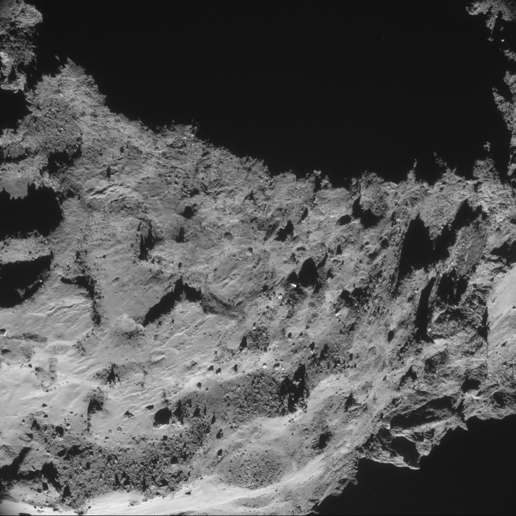
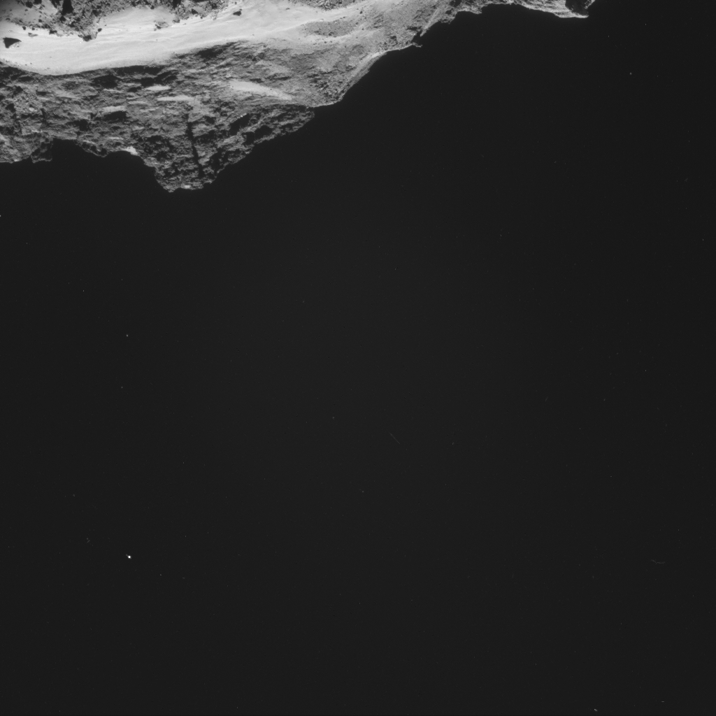
Montage of four images of Comet 67P/C-G taken on 30 September, from a distance of 18.1 km from the centre of the comet – our closest image yet.
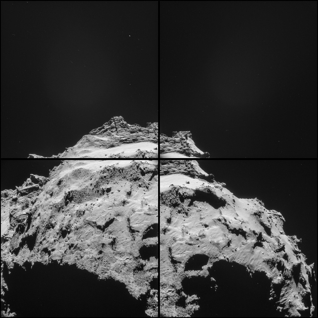
Four image montage of 67P/C-G taken on 30 September from 18.1 km, and featuring primary site J. Note that a “feature” can be seen against the dark sky in the centre of the upper two images of the montage, namely a broad, diffuse region of low-level brightness. Our current thinking is that this is likely due to internal scattering of off-axis light (i.e. the comet itself) in the NAVCAM optics, rather than comet coma emission, but we’ll making further checks.
Credits: ESA/Rosetta/NAVCAM
The four 1024 x 1024 pixel images making up the montage are provided at the end of this post: for processing details please see the previous post. The image scale at this distance is about 1.4 metres per pixel, so each 1024 pixel frame measures about 1.4 kilometres across.
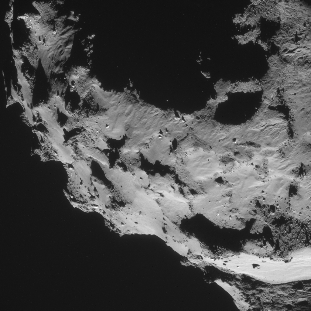
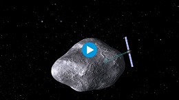
The image features Site J, the primary landing site for Rosetta’s lander Philae. A context image is provided below.
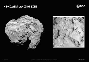
Site J, Philae’s primary landing site.
The effect of the comet’s rotation and movement of the spacecraft in the twenty minutes spanned by the imaging sequence can clearly be seen by comparing the first (bottom left) and last (bottom right) image of the montage. Features visible in the first image, such as the depressions close to the right of the first image, are cast into shadow twenty minutes later.
This makes mosaicking the four images together very challenging in 2D, although we know that some of you out there are doing great work in ‘draping’ the images over 3D shape models, similar to the one from OSIRIS which we released last week. Mattias Malmer’s impressive work with our NAVCAM images caught our attention in particular (thanks Mattias!)
Once again, these four frames contain a stunning array of features. In the upper frames, there are steep cliffs, exhibiting clear horizontal layering with several vertical grooves or fractures. Other exposed faces, such as those seen most clearly in the lower left frame, resemble more of a rubble pile with discrete boulders of varying sizes.
Towards the middle of the lower left frame, there are also the beginnings of exposed ledges, again with rubble at their bases as they become more eroded. Interspersed is much smoother, fine-grained material, seemingly sculpted into ripples in some places, reminiscent of some wind-swept features seen on Mars (and Earth for that matter), but which on 67P/C-G are presumably linked to activity and the result of differential erosion as material is lifted from the surface.
The entire scene disappears into shadow at the bottom of this image, corresponding to the steep walls of the large depression that define the previously considered candidate landing Site B.


Discussion: 92 comments
Hi, this is nice. But where are the enormously better images of the OSIRIS system from 18 km? Please, only one detail of the surface!
Yes, just a humble 10×10 meters and this small band of narrow-band nerds will sing your praise!
I really find myself ridiculous about this Osiris ‘appetizers affair’. Even made an stereoscope.
😉
In these images it appears as though dense /large ejecta (or other material) have (re-) impacted on the smooth (fluffy, dust, bituminous, whatever) surface, if indeed so, it should be possible to make predictions on the mechanical properties of these surfaces. well, provided some better resolution images… Please, please Emily, tiny password to the archives of that other camera? 😉
Wonderful set of images with a low viewing angle and low-angle lighting. Good material for the Geomorph comments.
So many questions.
I agree that the “odd blobs” may be internal reflections in the camera. But they don’t always act like flare and could very well be broad dust emissions. We’ll see…
–Bill
If you zoom in on the top of the jets seen in the picture taken on 26/9/2014 on either side very similar hazy blobs can be seen.
https://www.esa.int/spaceinimages/Images/2014/10/Comet_on_26_September_NavCam
I wonder if this is reflected light from the surface being back scattered towards the camera by dust/vapour in the diffuse extended coma. There appears to be no connection to the surface in either picture.
Emily!
Wow! Thank you for mentioning me! I’m extremly flattered that you link to my work. (I should probably say play because it really is not work when it is this much fun)
These new wonderful images are really getting down there in amongst the rocks! I desperatley need stereo coverage of the region to be able to do these justice. but I might still give it a go with Shape from shading…
Any stereo (ish) navcam releases in the works?
This beautiful Navcam mosaic shows very clearly the ‘star shapes’ and ‘necklaces’ seen before on Osiris.
“reminiscent of some wind-swept features seen on Mars, but which on 67P/C-G are presumably linked to activity and the result of differential erosion as material is lifted from the surface.”
Why would the material be lifted off the surface in accordance with the standard model? In the electrical interpretation, cathodic etching of the nucleus is responsible for the erosion. The same process would produce the craters, ridges, boulders, fine powder, and that peculiar “luminous feature”.
Please anyone with experience on crystallography give us some preliminary advice on the ‘supporting’ structure of crater on bottom right corner. An educated guess.
Standard theory will find easier to describe this as fractured ‘cells’.
I will just tell this ‘supporting structure’ is perpendicular to the apparent subduing layers ‘drawing’ the surface more to the left.
I think that “supporting structure” Logan, is an illusion created by the shadows of the overhanging crater wall. Shadows in a vacuum are extremely sharp and linear.
Strange that there is little or no evidence of the original projectiles that created all the craters. Some of them must have been mainly rocky in nature, so you would expect the remains would show up as piles of boulders in the bottoms of the craters as the more icey material around them “eroded”. Perhaps this gives clues to the makeup of the Kuiper belt or scattered disc objects that are most likely to have generated the majority, if not all the craters. Collisions with other mainly icey objects would leave virtually no evidence as the projectile would likely be melted by the collision, or if any remained, “erode” at a similar rate to 67P.
The “dune” like nature of the flatter dustier plains I think is just the underlying surface topology. There are numerous examples of strata, which show different rates of “erosion” creating ridges and vales, along with fractures and faults of different widths and depths which covered in dust/ejecta, would also give this rippled appearance. This can be seen on snow covered glaciers on Earth.
This lower angle view of the Philae landing site, doesn’t allay any fears for its safe landing. Although there are lots of flatfish areas, there also lots of cliffs and neighbouring precipitous drops and cavernous craters. I would be a lot more optimistic if the orbital manoeuvre guys at ESA could manage an error of only a couple of hundred meters in their landing ellipse. Lots of great stuff to see though, if Philae does land safely. Their “driving” skills have not been found wanting yet and I am sure they were being conservative when estimating the error margins. Good luck little Philae.
I suppose the Philae team have by now worked out the landing trajectory: at what point in Rosetta’s orbit they will release, how they will aim, solar angle during the flight path, etc. I understand that because it is risky they might not want to release all the details, but it would be nice to get an idea of what is planned so that people get an idea of what will be happening during those tense seven hours. There is a lot of concern for Philae on this blog.
Once the formal “lander readiness review” has taken place next week, we will be able to share more details of the timeline leading up to the landing.
Please Emily, don’t give agenda on any transmission events. Please delete this log.
Very probably you are right Robin. Wouldn’t like to give up so easily in this one, nowadays. ‘Active’ craters, even ‘active’ caves (which looks to my mind like nothing else than ‘side exausts’ of craters) are complex entities.
At pixels 1971, 1905 of
https://www.esa.int/var/esa/storage/images/esa_multimedia/images/2014/10/comet_on_30_september_navcam/14955234-1-eng-GB/Comet_on_30_September_NavCam.jpg
Suggesting this is the ‘naked’ structure transferring gas to the chimneys of crater’s rims.
Hi Logan. I’m glad someone else is more addicted to this mission than me. I considered that explanation, but could not come up with an explanation as to why the stream was not continuous from the surface. There does appear to be some sort of collimating by the crater rims. There is a significant curved boundary at the bottom of both “dust clouds”(?). Maybe an effect of initial velocity of material leaving the surface and the bowl shape of the crater therefore, reflected in the shape of the cloud. Material with insufficient velocity will not remain suspended and fall back to the surface. At some critical velocity material remains suspended, presumably related to the escape velocity of the comet.
The other possibility I considered, is the time it takes enough ice to form on dust particles to make them visible. This I feel is a less credible explanation as the reflectivity of the ejected material should be similar to the surface and so should show up provided the density of the cloud is sufficient.
The effect of the comet’s rotation would tend to disperse such clouds, or dictate that these are very temporary phenomena created by a particular level or range of energy arriving at the surface. The clearly defined streams of material seen at the neck show some twisting due to the rotation of the comet. This image is taken pretty much at the equator. so one would expect a cloud of ejected material to be continuous rather than in discrete blobs if this was not the case. The amount of sunlight, thus energy, arriving at the surface is variable, so I suppose such particular energy levels may only occur at particular times during the comet’s rotation.
Thus a pretty complex scenario with lots of ifs and maybes, thats why I plumped for back scatter. I did seriously consider posting the above speculation though. Finally didn’t though, as Emily related that the science team had considered many possibilities and ruled them out. This I thought could be one of them. These things are complex and unknown scenarios, so I’m not ruling it out as an explanation or part of the story anyway.
Think many of us agree should be a lot of friction below the crater’s plates. Without a good educated guess about electro-resistivity and magneto-resistivity my mind impact at this point.
:/
‘…The other possibility I considered, is the time it takes enough ice to form on dust particles to make them visible.’
Erich told me about incredibly low ‘atmospheric’ pressures as a rule. Think of crystallization processes inside. Not outside.
Other scenario is that ionization occurs outside.
(about to be hit)
😉
Have seen photos of ionic flux and luminance does not necessarily start at cathode surface.
By now Rosetta university teams knows how much of that light is reflected or emitted.
Different length lines on the ‘darkened’ sky (some even curved) could talk of ejecta.
Hi Logan
Do you mean the straight and the rather fuzzy line in the starry sky on image no. 3 from the top? They might be moving objects as other objects are point shaped?
Was not furry yesterday. I swear!
😉
Good eye! The longer dim streak in the third image certainly looks plausible. It could be a cosmic ray impinging on the detector, but I would expect that to be brighter. I measure that track as 24 px long. I found some discussion, which may or may not be correct, indicating that the exposure time of the NAVCAM is 30s. If we assume that the prospective debris is at the same distance as the comet, then the minimum speed implied (if its path is orthogonal to the camera) is 1.2m/s. This doesn’t sound implausibly fast to me, but it is hard to say much more than that.
Maybe I’m starting to get too much attached to this bag of trash; But there is enough order not to be a simple pile. There are enough ‘objects’ not to be simple rubble.
‘Rubble’ applies more easily to our moon than to 67P.
I would tend to agree with you Logan. The very low density though, does take some explaining if it is as solid as it appears. Even highly compressed, solid looking, regions at the bottom of glaciers on Earth have small trapped air bubbles. With temperatures within the nucleus being below the freezing point of Nitrogen, gas bubbles would seem unlikely. There must be a lot of empty space somewhere within the comet. The only conclusion I can come to at the moment is that the material below the surface is very porous. Perhaps like an Aero chocolate bar. At the surface it melts to give a smooth solid surface, but inside is full of voids filled with vacuum.
Solid nitrogen actually has a density greater than ice, 1.0263 g/cm^3. Liquid Nitrogen has a density twice that of 67P at 0.8 g/cm^3. When it does change to a gas though its volume increases by nearly 650 times. When pockets of frozen Nitrogen sublime the “explosive” expansion would fracture and split other ices, rock as well come to that, as well as eject gas/dust at considerable speed from the surface. Argon has a higher freezing point at ~83 K and would have a similar effect.
That may explain the cracks and fractures on exposed crater walls and cliffs, but the clear strata on the cliffs above the neck and the exposed facets on the large lobe in particular, suggest compression either by a huge collision generated shock wave, or that 67P is actually a very large chunk smashed off the surface of a larger body. One with sufficient gravity to have undergone consolidation. If that were the case heavier materials, rock and metals, would have been removed from the surface of such a large object.
Maybe 67P was once part of a large Kuiper belt object like Eris, Triton or Pluto. The surface of Triton is known to be made largely of Water and Nitrogen ices and Voyager 2 saw “Black” material deposited on its surface by Nitrogen geysers. Maybe the science team will be able to tell us if that is a possible or likely scenario.
@Robin S. I think your analysis doesn’t take into account the dynamic and heterogenous nature of comets. For instance, when you say”With temperatures within the nucleus being below the freezing point of Nitrogen”, it fails to take into consideration that gas is, right now, coming from within the nucleus. That is evidence that there is warmer temperatures somewhere under there, or at least, opportunity for gas bubbles. Also, you only consider solid and gaseous phase compounds. You don’t consider soft, tarry, carbon-rich mixtures such as crude oil or tar that could be on the surface clumping together and making a seal to smaller vents, or a kind of cementing process leading to self supporting structures such as we see.
Hi Marco. I take your point about the temperature gradient, but the only evidence so far revealed to us is the surface temperature and a broad range for the subsurface temperature, 30 -160K. Nitrogen freezes at 63 K in a vacuum so within the nucleus there might be frozen Nitrogen. Assuming the temperature is higher nearer the surface there would indeed be gaseous Nitrogen just below the surface and as I implied could be an explanation for the streams we have seen.
I certainly had not considered your second point though, a good one it is too. Some of the formations do seem to defy intuition by remaining in place. Either the weird gravity vectors or some sort of tar “glue”, or both could explain them. It could also add strength to the surface layers being called plains on the lobes and be part of the reason no obvious vents have appeared there yet. The neck region does “appear” lighter and so may not be as resilient. With more activity there, there is less time for organics to build up there. A sort of reinforcing feedback loop. Just another vaguely plausible theory that might explain why the neck area is so preferentially being eroded.
These things and many more we hope will become clear in the fullness of time. No doubt some questions will remain unanswered, the biggest being are other comets, in particular those that come from the Oort cloud, the same as 67P. Comet Siding Spring, which passes Mars shortly, is thought to be fresh from the Oort cloud and may be different to 67P entirely.
The temperature gradient is still a big unknown. There is theoretically a lot of structural pressure in the neck due to the weight of the two lobes being held apart. Some of that pressure could lead to internal heating and pressure. Heating and pressure could liquefy water ices. Liquid water in a porous environment has movement governed by a delicate balance of capillary action, gravity field, centrifugal forces, gas pressure and convection. This is clearly too complex to be modelled, but it doesn’t surprise me that there is an “exhaust” of water vapour originating fairly deep in the comet that finds the path of least resistance to the surface to discrete vents. Close subsurface solar heating induced sublimation would not do that.
Comet Siding Spring is an exciting counterpoint to Churyumov. It should be just close enough to resolve the nucleus to a few pixels. Albedo, and whether it is a bilobe or even have multiple nuclei (Hale-Bopp was suspected to have two nuclei) are things that should be visible.
My initial point was to try and find reasons for the low density of 67P, less than half that of Water ice. One explanation would be that there are pockets/bubbles of gas throughout the nucleus, as in glaciers. In order for frozen materials such as Nitrogen, Carbon Dioxide or Water to become gases, or liquids in the case of Water, there must be empty spaces for them to expand into. As a compact non porous body this would not be possible, the internal pressure of the solid would prevent this and so the density presents a problem.
Thus I attempted to explain my reasoning for the porous nature of the nucleus. If it is a porous body then anywhere where the pressure maintaing the solid state, is released, assuming a sufficient amount of energy/heat, the ices sublimate to a gas. For the reasons you explained, over the lifetime of the comet sufficient internal energy could be produced to allow sublimation into spaces which, initially occupied by vacuum, are now filled by low density gases within the body of the comet.
Like you, I tend to think the energy and mechanism to produce the streams of material from the neck region is likely to be internally created in the manner you describe. We can only see vague hints of very slow outgassing on the lobes. This sort of diffuse low level activity is more likely to be associated with solar energy and near surface sublimation. This may change as the comet gets closer to the Sun.
I am very grateful to you Robin for this very thoughtful answer. Really agree with you in ALL of the points as paussible. Only perceptual difference is that my favorite models consider Kuiper belt just an ‘storage’ area. My favorite models considerer the ‘bow’ of the solar gas disk booth an accretion and capturing area for comets, and some other small objects.
That one consideration has lot of consequences on age, structure and composition.
I have not heard the idea of the heliopause being a source for comets. It sort of makes sense. Dust and other material pushed out from the inner solar system by the solar wind, might well collect in a region where that pressure is balanced by the interstellar wind.
The solar system is currently travelling through a vast dust and gas cloud which indeed could add to the material in this region. Kuiper Belt Objects are postulated to be in a holding pattern dictated by gravitational resonances with Neptune, Pluto being one of them. We can only hope Rosetta might be able to shed some light on these things, eventually.
Do anyone have a bit of data on surface metals?
Microsoft ICE stitch: https://l2.picsurge.com/8rzoMg/ESA_Rosetta_NAVCAM_140930_D1_stitch.jpg
Nicely done, Maksim.
We science fans are just like scared doves. If someone fly, everybody fly.
Hi People on the Bridge, are you going for the 10km orbit?
is it a 2*2 binning image or not.
Please clarify
Micro-gravity really makes weird things in icy bodies.
Interesting outgassing on photos C and B.
Thanks for showing, Ingo.
Fantastic pictures. I like cropping out little sections close to the limb and imagining they are surface views. Al I can say is – I’m glad I am not dropping my own personal zillion-euro spacecraft on that surface. It’s a great adventure, and we are lucky to be along for the ride.
Emily, I find the change of tone and vocabulary in this post compared with previous ones both intriguing and encouraging, in particular the admission by the ROSTTA team of the existence on 67P/C-G of:
– “steep cliffs, exhibiting CLEAR HORIZONTAL LAYERING with several vertical grooves or fractures” (my capitals for emphasis). What are THEY doing on a “primordial, dirty ice-ball”, supposedly visiting us from the outer confines of the Solar System? We’ve all seen this extremely common sort of stratified rock formation down here on Earth (either on nearby rocky coastlines or canyon walls,or in photos of them). What are they doing on 67P/C-G?
– “ WIND-SWEPT FEATURES seen on Mars (and Earth for that matter), but which on 67P/C-G are presumably linked to activity and the result of DIFFERENTIAL EROSION as material is LIFTED FROM THE SURFACE” (my capitals for emphasis).
Three corresponding comments:
The origin of the features observed in this image of 67P/C-G can have nothing to do with being “WIND-SWEPT” here, for obvious reasons (nor on Mars, for that matter, since there is almost no atmospheric “wind” on Mars, given the vanishingly small density of the Martian atmosphere…) There is necessarily another mechanism at work.
“DIFFERENTIAL EROSION” is, in my understanding of the standard geophysical theory, the kinetic, abrasive, work of wind and water on rock over untold eons. Hardly applicable either, presumably, to a comet travelling through a near-vacuum…. But, crucially, “differential erosion”, which requires an EXTERNAL source (whatever it may be), can clearly have no connection with hypothetical, standard INTERNAL “outgassing” phenomena which, I note, are no longer referred to in your post.
Above all, your idea that “MATERIAL IS LIFTED FROM THE SURFACE” also requires an EXTERNAL operator and thus has equally little to do with the mainstream dogma of “dust-being-blown-out-of-the-comet-by-outgassing-from-ice-hidden-below-the-surface”. You accurately describe the result of the electric “cathode etching” phenomenon which Ross refers to in his earlier post. Your phrase could even have been taken directly from any one of several much more dissident websites….
Personally, I am delighted to see this radical change in the language being used. The mechanisms which created 67P/C-G and which are continuing to shape it are necessarily different from those which were theorized many years ago at a time well before we had started to acquire actual images of comet nuclei.
My guess is that the so-far undisclosed OSIRIS images of what is REALLY happening at the surface are starting to help move things forward and that the penny is beginning to drop…
Methinks something BIG is afoot!
Hi Thomas,
First of all a general comment that although I don’t have time to respond to all posts personally, I do read them all, and noted in recent ‘CometWatch’ posts that many of you wished to have more description accompanying the images. So this is what I have been doing; that is, pointing out some interesting features that caught my eye. As noted in a previous post however, thorough scientific analyses of what 67P/C-G’s features actually are, how they came to be, and what they mean for this comet’s history and evolution will come in the form of scientific papers in the fullness of time. What I can do in the meantime, however, is to not only point you to interesting features, but also make comparisons to features that we see on other Solar System objects.
To respond to some of your specific comments:
You’ve taken my ‘wind-swept features’ comment a little out of context here because I actually wrote “*reminiscent* of some wind-swept features seen on Mars…”; (by the way, there are in fact there are plenty of examples of wind-swept terrains on Mars, e.g. https://www.esa.int/Our_Activities/Space_Science/Mars_Express/Mars_Express_reveals_wind-blown_deposits_on_Mars and https://www.esa.int/Our_Activities/Space_Science/Mars_Express/Cascading_dunes_in_a_martian_crater for two of many examples).
As for erosion, it can take place over a range of time scales, and by a range of processes. A difference in erosion rates in nearby locations is not really a big surprise if you consider differences in hardness of the surface materials – softer materials erode faster than harder materials (think about coastal regions on Earth), differences in local topography, and of course, the fact that comets are active bodies. For example, solar energy input will influence the rate of sublimation erosion, and internal outgassing will play a role. This may not be as explicitly written as in the previous post (https://blogs.esa.int/rosetta/2014/10/02/cometwatch-26-km-on-26-september/), but there is no radical change in my language, it is just that different features/processes are clearly more visible in some images than others, now that we are at these close distances, so I may not always pick the same things to talk about in each new post.
Hope that clarifies the intention of our CometWatch commentary.
Best wishes,
Emily
Many thanks for taking the time to answer so fully and clearly, Emily.
I respect and admire the work you’re doing even if, of course, I have a very different take on the images and data you are providing us with. I have no problem with waiting for the forthcoming in-depth analyses, which will help to confirm or falsify the various competing paradigms being aired on this blog.
Another perspective on the peak in the upper left image with the vertical fracture is seen in the image of 14 september (https://blogs.esa.int/rosetta/2014/09/17/cometwatch-14-september/ and also the sharpened image in stuart atkinson’s tour of 67p, https://cumbriansky.wordpress.com/2014/09/18/a-tour-of-67p/). Does putting both these pictures together give any ideas on what forces are at work here?
There is an OSIRIS image of this feature too Kamal. It shows it from the left side in respect of this latest view.
https://www.esa.int/spaceinimages/Images/2014/09/Comet_on_5_September_2014
This looks to be the remnants of a crater rim. The impact would have compacted the surface layers, increasing their density and slowing their “erosion”. The cracks and fractures could be from the original impact, but also from the frost/thaw cycle that cracks rocks on Earth. Each time 67P orbits there is temperature increase followed by a decrease, expansion followed by contraction. Different temperatures at which different icey materials sublimate, is probably involved too. Also see earlier post.
Robin: Thanks for your response, but I am not sure we are talking about the same feature. The peak I am talking about is on top of the present (6 October) picture, with the strange ribbed structure and a vertical depression in the middle. I call it “chocolate bar” because that is what it reminds me of. In Stuart Atkinson’s image
https://cumbriansky.files.wordpress.com/2014/09/circles.jpg it is just left of the “plain” (the circle marked 7). To me the peak in the Osiris image of 5 September seems to be a different one further up, somewhere around the features marked 1 and 2 on Stuart’s image. As I said in another post, we need a map with names, and we need to label every feature which is seen in multiple images so that everybody is sure that we are talking about the same thing.
Hi Kamal. Good point about getting orientated. I thought the 3D model would help, but the surface topology is not resolved well enough. We have not even got a name for Site J yet, so I think the chances of names for other features are slim. The names should have an ancient Egyptian connection, so perhaps we should name things for ourselves using well known Pharaohs like Cleopatra. Get our names in first as it were.
Robin: I had a post on Emily Lakdawalla’s blog https://www.planetary.org/blogs/emily-lakdawalla/2014/09151433-a-landing-site-for-philae.html regarding names, it may be tricky to deal with what various people might want. Stuart’s idea of just using a picture with features marked with numbers (now Bill has a map of the J site area with features marked with letters) which people can refer to is sufficient for the moment. Also, as is evident from the lively discussion going on here, a comet has rather impermanent structure!
These “wind-swept” comparisons of the evident erosion on the comet nucleus to Mars terrain only furthers the confirmation of electrical phenomena shaping the morphology we observe. It is assumed that wind and water has shaped the Martian landscape, not confirmed and measured like on earth. The comet cannot possibly be eroded in the same way, as it is traveling in a vacuum where zero erosion should occur. So WHEN electric discharging is confirmed on the comet, I will be expecting the same comparison to Martian features, such as the monumental electrical scar Valles Marineris.
https://mattias.malmer.nu/2014/10/comet-on-september-30/
Mosaic, 2d and anaglyph stereo.
Rendering animation overnight…
I hope this isn’t the case, but when I asked one of the PIs responsible for the OSIRIS instrument, he said that images would be released from OSIRIS after the six month proprietary period. The data will be released to the Planetary Data System (PDS) after proper calibration. I sure hope some images will be released before the six month proprietary period.
What CAN we do to teach these selfish PIs who their paymasters are, and just how much they are discrediting their own reputations and those of the whole field of planetary science by their deliberate withholding of publicly funded data? Were I on a funding committee, I would definitely consider such behaviour a “black mark” against them, irrespective of any papers which might eventually appear concerning that data!
The Rosetta mission is not Apollo 11. Back then people were given a live transmit. Today it’s private property. Funny: recaptcha wants me to spell “shame”
Just on the specific point of “live”, do remember that while the Moon is at 400,000km from Earth, Rosetta and the comet are at about 400 million km, i.e. 1000x further.
Thus, all things being equal, radio signals from Rosetta are about a million times weaker than they are from the Moon. That results in very low data rates from Rosetta, meaning that it takes a long time for images to crawl back, even if compressed.
So, there can’t be any “live, real-time” from Rosetta, independent of any questions about “private property”.
Carbonated Black Water Ice mountain peaks at Comet 67P- CG, is a strong indication for dual nuclear H2, O and even C production, including upward pressure on ice mountain formation, from inside two nuclei of the Comet.
According to Quantum FFF Theory. See:
http://www.flickr.com/photos/93308747N05/15280458797/
Knew Black Water is everywhere.
😉
Sorry the image does not work.
see image 197 at:
https://www.flickr.com/photos/93308747@N05/?details=1
Is the bright point Saturn? If you zoom in it has the shape of Saturn. Very nice view!
https://drive.google.com/file/d/0B6Ho_4s88OOmaTZMMU5OM2d6YTA/view?usp=sharing
Wow, Stuarts 67p tour, who needs OSIRIS when Stuart can produce those pictures from Navcam.
See link on Kamal Lodayas blog.
Some of the best pictures I have seen, fantastic close ups of terrain and bolders.
ESA thanks for the bare pictures, but you have a lot to live up to from the data that comes from the bloggers.
Please do better.
QUOTE:
“emily says:
07/10/2014 at 10:25
Hi Thomas,
First of all a general comment that although I don’t have time to respond to all posts personally, I do read them all, and noted in recent ‘CometWatch’ posts that many of you wished to have more description accompanying the images…. ”
===
Thank you for your original explanatory comments and the follow-up post, Emily. I appreciate your commentary with the images– this is a strange new world and sometimes our “rocky planet analogs” don’t quite fit, although they’re all we have to work with. Many of the processes are the same, some will be new and mysterious. This is a new world.
And I also appreciate that sometimes comments can be taken out of context and reprocessed by those with an agenda. I hope that this will not affect the quality of your Blog presentation.
–Bill
Bill, I assume (since you left in my “name”/avatar in your initial quote) that in your above comment, I am one of those “with an agenda” you are referring to.
Personally, I can assure you that I have absolutely no axe to grind and I don’t need one:
-I am over 60 with a more than respectable career in applied research behind me that had nothing whatever to do with anything connected with cosmology, astronomy or electric engineering. I have thus never earned any sort of income from the ideas I occasionally put forward on this blog. I am what might be called a simple, unexceptional, citizen scientist with an enquiring mind (like most of the other contributors to this blog, I guess).
-After being an enthusiastic proponent of mainstream Big Bang theory for most of my working life (as you still appear to be yourself), I started having doubts (hence the choice of my avatar) around 15 years ago. Why? Because the observations flooding in (both images and data), started to increasingly belie the standard “Big Bang” paradigm which had been formulated decades previously. That was well before we started seeing the extraordinary images of the cosmos which the exponential technological progress of recent years has since provided us with thanks to our new telescopes, our new probes and our new processing capabilities. And it so happens that the most extraordinary images and data (especially compared with the expectations and the “agenda” of the standard theory) are without the shadow of a doubt those being sent back to us currently by Rosetta. I thus feel entitled to post on this blog without being suspected of ulterior motives and I eagerly await due disclosure, in due time, of the data and images obtained, in the sole interest of both science and the scientific method.
If the detailed data and images secured by the extraordinary accomplishments of the ROSETTA team should, once disclosed, ultimately and conclusively refute the electric universe paradigm which I (and many others) currently prefer to the standard “dirty snowball” model, then I will simply go back to the drawing board. And I might even feel obliged to eat my hat.
Too much C2H5OH last night. How easy is to see what I want to see. Apologies to you all.
It seems everyone is allowed flights of fancy with this Comet.
Like the rest of you I would dearly love to see the close up of the surface of the Comet, this would settle a lot of conjecture.
If we have to wait until noted Scientists present their papers for discussion we may find even they have taken the wrong impression of the Comet.
How craters are formed and the landscape made is open to all sorts of interpretation but the stark fact remains, we need evidence and data.
Given the lander has a 50/50 chance of landing safely I can wait until November.
All is not lost even then as Rosetta will still circle the Comet and hopefully give us more impressive pictures to evaluate.
Clive
Hi Emily,
Thanks for your latest post, which was extremely interesting and informative. With every navcam released, and every blog post written by yourself, 67P is becoming more and more a real world to us. The features are coming into sharper focus now, and we’re starting to make (a little!) sense out of what we’re seeing. This is genuine exploration in its purest form – seeing somewhere new, for the first time in human history. Your efforts, Emily, and ESA’s ROSETTA outreach and media work, are greatly appreciated out here by the tens of thousands (maybe more) of armchair explorers, amateur scientists and space enthusiasts who are supporting and following this mission.
Lots of people are now commenting on the frustrating lack of OSIRIS images, and I share that frustration, although I know it is absolutely nothing to do with ESA itself. The images are strictly under the control of the OSIRIS team. The continuing lack of released OSIRIS images into the public domain is now becoming nothing short of a disgrace, and needs to be addressed. This wonderful mission, and the incredible scientific team behind it, deserve better than this.
The “proprietary period” makes sense in that it allows the scientists involved to look at the images before anyone else, and use them for writing papers and journals, etc. That’s how modern science works, and no-one sensible is questioning that. But…. It simply cannot be the case that *every single OSIRIS image taken so far* shows something *so* important, *so* scientifically paradigm-shifting that it has to be locked up for 6 months, that’s simply not possible. There must be some OSIRIS images now that could be released without any risk to the mission or the careers of the scientists involved.
The release of even a handful of images, showing close-ups of individual boulders, or crumbling ledges, or a single vent, would raise the mission’s profile enormously, and really set the stage for the Philae landing.
I urge, in the strongest possible terms, the people in charge of the public release of the OSIRIS images to think very carefully about the harm they are doing to ESA’s image and the ROSETTA mission, and to also think for a moment how huge the Outreach impact would be if they released some images. Within hours they would be on every space blog, forum and website, on the front pages of newspapers, and on TV news programmes around the world, showing the people of the world what an incredible mission ROSETTA is, how much ESA has achieved, and more.
Come on, OSIRIS team, and ROSETTA Managers, this problem really needs to be addressed. The ROSETTA team did a fantastic job getting the public interested in the mission, with all the cute animations, competitions and more, and by the time ROSETTA reached 67P countless thousands of people around the world, young and old, felt involved in the mission. Now that ROSETTA is orbiting 67P and taking, we are told, “stunning images”, those same people are naturally puzzled and frustrated that they can’t see those images. It makes no sense, and in this modern age it is just wrong.
I hope the OSIRIS team change their minds soon, and release some of their images. They must show wonders the like of which we have never seen before…
In the meantime, thanks again Emily – and all of the ROSETTA outreach and media team – for your continuing hard work. It is greatly appreciated.
Well said…
https://cumbriansky.wordpress.com/2014/09/30/oh-osiris-2/
Thanks Stuart, your kind words on our outreach efforts are appreciated! We also enjoy the crops and ‘tours’ that you create from our image posts, too. Keep it up!
Apparently ‘cohesive’ material at pixels 256, 1545 of
https://www.esa.int/var/esa/storage/images/esa_multimedia/images/2014/10/comet_on_30_september_navcam/14955234-1-eng-GB/Comet_on_30_September_NavCam.jpg
Could you really tell me that this is not a small crystallization at pixels 666, 1479 of
https://www.esa.int/var/esa/storage/images/esa_multimedia/images/2014/10/comet_on_30_september_navcam/14955234-1-eng-GB/Comet_on_30_September_NavCam.jpg
This ‘rubble’ area at 744,1131 looks anything but random:
https://www.esa.int/var/esa/storage/images/esa_multimedia/images/2014/10/comet_on_30_september_navcam/14955234-1-eng-GB/Comet_on_30_September_NavCam.jpg
Also at pixels 1557,2007 of
https://www.esa.int/var/esa/storage/images/esa_multimedia/images/2014/10/comet_on_2_october_navcam/14960273-1-eng-GB/Comet_on_2_October_NavCam.jpg
Could it be an exemplar of ‘primordial’ material?
Here is a comparison between an earlier OSIRIS image and the recent Navcam image of Comet 67P. With key landmarks labeled:
https://univ.smugmug.com/Rosetta-Philae-Mission/Rosetta-Comparative-Series/i-X2FQVDv/0/L/Philae_primary_landing_site_J_close-up–OSIRIS_%2B_30sept_navcam-L.png
–Bill
Thanks, Bill. Have you marked the two pits that have been pointed out near site J?
The particular fracture Kamal comments is at pixels 750,812, dislocation is apparent.
https://www.esa.int/var/esa/storage/images/esa_multimedia/images/2014/10/comet_on_30_september_navcam/14955234-1-eng-GB/Comet_on_30_September_NavCam.jpg
When are we going to start talking about comet ‘plate tectonics’?
😉
the gravitational forces holding this thing together are so small I’m surprised more material isn’t “floating off” the surface.
However slight the gravitational attraction of 67P/C-G may be, it is still sufficient, if there are no other forces in play, to hold everything on the surface “down”. In the absence of such forces, there is no reason why anything, even the finest dust, should simply “float away”.
On the other hand, material may be “blown off” the surface in discrete locations by hypothesized out-gassing from specific “vents” (as in the reworked “dirty snowball” model of comets); or it may be “lifted off” or “blasted off” any or all parts of the surface by a process which is commonly used for industrial purposes down here on Earth, known as EDM (electric discharge machining) or “cathode etching” (as in the “electric” model of comets).
In both of these cases, there is a stronger force at work (thermomechanical or electromagnetic, according to the preferred paradigm) which easily overcomes the tiny but real force of gravity.
Well, at the end, the only other force at work is the electromagnetic force 😉
(any “thermo-mechanical” phenomena is just due to electromagnetic interactions on a small scale + large number of interacting elements)
Maybe some bonding due to physicochemical interactions as with clay or cement, or frozen liquids holding materials in place. It will be interesting to find out what percentages of metals, silicates, water, methane,…. are present.
The shadow at pixels 1492,1574 is baffling me.
https://www.esa.int/var/esa/storage/images/esa_multimedia/images/2014/10/comet_on_30_september_navcam/14955234-1-eng-GB/Comet_on_30_September_NavCam.jpg
Comparing one image made by Osiris from a 65km surface distance and the comet NOT filling the frame, with the stitched Navcam image from a 16 km surface distance OVERFILLING the stitched frame. They have about the same resolution. The difference in field of view is a factor of four so is the difference in distance to the comet in those two images. The Osiris has 2k by 2k pixels, this is then clear that the Navcam stitched images have 1k by 1k pixels leaving 512*512 pixels per frame and this again means that the pixels in the navcam are still binned in 2*2 pixels.
The Osiris NAC has a 19 micro radian pixel resolution and the binned 2*2 Navcam pixels have a 170 micro radian resolution. Thats about a factor of 9 in linear resolution difference.
By getting four time closer and stitching the images 2 by 2 the resolution is almost the same. Proving that the pixels in the Navcam are binned twobytwo.
Now imagine if we could se a huge chessboard area on the comet then the the Osiris at this distance can detect the pawns on the board but the Navcam can only se the board.
This is a bit frustrating that the we are not able the get one of those Osiris images in eyesight with its hundredfold better areal detail recognition capacity.
On top of the pixel-resolution the Osiris has a better dynamic range then the Navcam and also has a set of color filters that can enhance some image detail.
To my opinion its about time that we get a spoiler before Philae is landing and make snapshots of some snowflakes.
I think it’s “just a rock”. Being aware that this is a nominal aiming point and Philae could send up anywhere, here is a detail of Landing Site J at 0.5 m/px:
https://univ.smugmug.com/Rosetta-Philae-Mission/Rosetta/i-bt8gKFC/0/L/ESA_Rosetta_NAVCAM_140930_D1%5B-%5D–Site_J_–res3x–enh2–annot-L.png
–Bill
This is a preliminary terrain map for the geomorphology of Landing Site J.. Based on the 30 Sept 14 NNavcam with a scale of 0.5 m/px.
https://univ.smugmug.com/Rosetta-Philae-Mission/Rosetta-Geomorphology/i-hjzcCZW/0/L/ESA_Rosetta_NAVCAM_140930_D1%5B-%5D–Site_J_–res3x–enh2–prelim_geomorph_terrain-L.png
Delineates the following terrains around the landing site:
G- light-toned rippled deposit
F- medium scree
E- medium-toned smooth deposit
D- dark-toned rippled deposit
C- rocky latered deposit 2
B- rocky latered deposit 1
A- crater rampart
–Bill
Thanks for both those images Bill. Having zoomed in on the first I think you may have some evidence for your theory of vents forming boulders or at least the many “half craters” we see.
Right in the bottom left of the image is a large “boulder”(?) with a bright area above it and its shadow below it. If you look at the top of the boulder/vent/crater, there is a fuzzy, fan shape, maybe 10-15 meters wide and 20-25m in extent, which has a definitely different transparency. Though a 2D image. it does appear to be almost perpendicular to the surface and casting a faint shadow. The white area clearly shows a discrete boundary as you move from left to right. In my view this is direct visual evidence of material being ejected from the surface at source. Whether the “boulder” has been created by the vented material is difficult to determine, but I would say the whiter material looks like deposits of fresh ejecta.
The boulder/half crater within the flat area you have labelled G, would appear to be another example, though it is not possible to see ejecta directly. From other views of Site J, I saw this object as more of a half crater or pit. Perhaps you know if the lighter material is to spinward or not. I still have serious trouble with orientation. It could of course, just be lighter due to the angle of the sun and not fresh ejecta. Will have to see some other angles to tell .
Hi Marco, of late came to think that tidal forces, if dominant in energy balance, are incompatible with neck deposits.
I need a little more guidance on where site J is on this image and how this image.relates to previous images of site J
Hi Rod. The centre of the landing ellipse is marked on both images with a cross. Refer back to the primary landing announcement photo of Site J for context, a cross at the same point can be seen. This is a slightly wider view than in Bill’s images. If you are still unsure of the context, when the 5 candidate sites were announced pictures of each site and their positions on the comet were marked.
https://www.esa.int/spaceinimages/Images/2014/09/Philae_s_primary_landing_site_close-up
https://www.esa.int/spaceinimages/Images/2014/09/Philae_s_primary_landing_site
https://www.esa.int/spaceinimages/Images/2014/09/Philae_s_primary_landing_site_in_context
https://www.esa.int/spaceinimages/Images/2014/09/Philae_landing_site_context
Hope this helps.