


From Bob Brewin (Plymouth Marine Laboratory, UK), 24 October – currently doing experiments for ESA aboard the RRS James Clark Ross on the 23rd Atlantic Meridional Transect
The past week has flown by. The figure below, courtesy of Arwen Bargery, shows the ocean temperature, salinity, fluorescence (an index of phytoplankton biomass), oxygen and beam transmission. These are all derived from the vertical profiles at each station we’ve so far sampled.
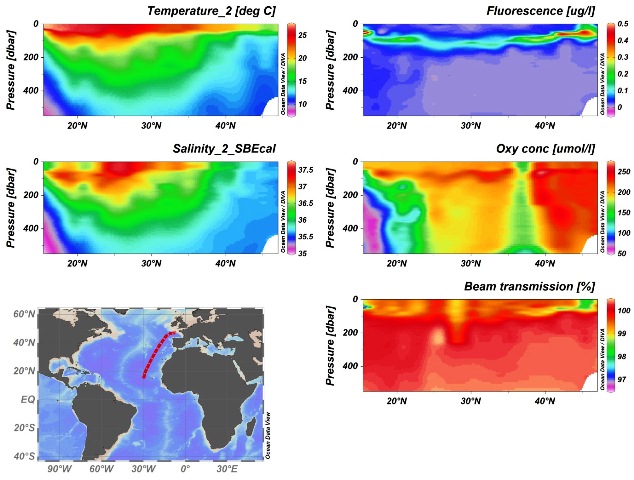
Vertical profiles of ocean temperature, salinity, fluorescence, oxygen and beam transmission. (A. Bargery)
As we moved south through the North Atlantic, we have observed a general increase in ocean temperature (especially at the surface) and salinity.
The fluorescence data indicate that at the start of the cruise we were in ‘high chlorophyll’ waters (relatively speaking). The fluorescence signal then weakened as we moved towards 30° N and the maximum concentration, often referred to the deep-chlorophyll maximum, DCM, deepened.
We then observed a shallowing of the DCM and a slight increase in the fluorescence signal as we moved toward the equator. This is likely be related to the upwelling of nutrient-rich waters associated with this region.
My daily routine, described in the previous blog post, has not deviated too much. However, a few days back I helped Giorgio Dall’Olmo deploy two Bio-Argo floats. These devices are at the cutting edge of bio-optical oceanography.
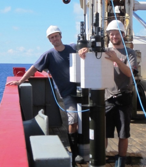
Helping Giorgio Dall’Olmo. (B. Brewin)
Argo floats essentially consist of a floating device that supports a number of oceanographic instruments, including temperature, conductivity (from which we can derive salinity) and pressure (from which we can derive depth) sensors.
In addition to these instruments, the Bio-Argo floats contain a suite of bio-optical instruments including light sensors, fluorometers and devices that measure optical backscattering. The floats sink to around 1000 m and, once every five days or so, the device floats to the surface while measuring these oceanographic variables.
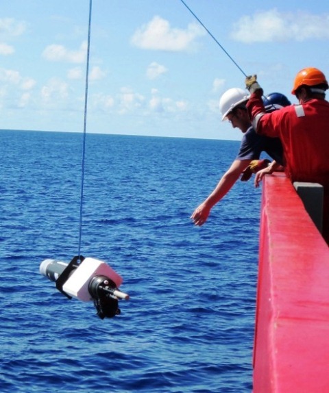
Deploying ‘Bio-Argo’ float. (B. Brewin)
This information is then transmitted to a satellite, which relays it to the Argo network where scientists can access the data in near-realtime.
Whereas ocean-colour satellite data can only observe the surface of the ocean (40m at maximum) these Bio-Argo floats extend the synoptic capabilities of satellite remote-sensing down into and through the photic zone, which is the region of the surface ocean where light penetrates.
The synergistic use of Bio-Argo floats and satellite ocean-colour data are likely to revolutionise our understanding of marine biogeochemistry and I was very excited to help deploy two of these new floats with Giorgio.
The temperature and humidity are now soaring as we approach the equator and shortly, I will be experiencing my first ‘crossing the line ceremony’.
This means that my first day off in nearly two weeks will involve trying to dodge, as best I can, the dreaded consequences of passing the equator for the first time on a ship (flights don’t count unfortunately). Wish me luck!
Craig Donlon, ESA’s Principal Scientist for Oceans, says, “Thanks Bob! Taking ocean measurements such as these is fundamental to understanding the data we get from satellites – all very much appreciated!”
Discussion: no comments